Approach
From the Wild Basin Ranger Station trailhead follow the signs for Bluebird Lake. After 3.1 miles, having passed Copeland Falls, Calypso Cascades, and Ouzel Falls, you will reach a T junction. Turn left for Bluebird Lake. (Going straight would take you to Thunder Lake.) After another couple of miles the trail forks again. Stay right this time, as the left branch goes to Ouzel Lake. The trail reaches Bluebird Lake directly to the south of the effluent. Cross the stream and scramble up the cliff on the north bank . Follow the north shore of Bluebird until a talus cone. Climb north from there and then west to gain the shelf where Lark Pond is found. A little bushwhacking may be required at the rim of the shelf. Go around Lark Pond and angle up due southwest toward Ouzel Peak that now looms above you.
Route Description
This route description assumes that there is a substantial snow cover on Ouzel Peak. In dry, summer conditions, one would probably find either the east ridge or the northern slopes preferable to this medley of the two. Since the north aspect of Ouzel Peak is an open face with an average angle of about 45°, it is a good place for
avalanches. Do not venture there if the conditions are less than ideal.
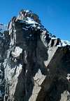
The north face of Ouzel sports a faintly defined northeast ridge characterized by rock outcroppings that merge with the east ridge towards the summit. The
route climbs on snow immediately to the right of the outcroppings until a prominent
tower is reached and climbed from the southwest--that is, by going around it. This tower marks the transition to the scrambling section of the ascent. In the lower part, it is better to keep to the left part of the face, which receives much less direct sunlight than the rest. From the tower, proceed towards the crest of the east ridge. Once there, pass a series of
gendarmes keeping on the north side. Do not miss the
views from the notches. Once on top, look for the summit cairn, which will be to your left, and take in the
scenery.
Descent: The easiest descent is from the pass between Ouzel Peak and Isolation Peak. Walk due west gradually turning northward along the
Continental Divide, surmounting the hump of Point 12,400. At the pass, go down the east slopes, which are initially steep, but then relent. Boulder-hop down to Pipit Lake, which you'll pass on the north, and then on to Lark Pond. Keep some distance between you and the outlet of this lake to avoid cliffs and rejoin the route you followed on your way up. Descend the shelf aiming for the talus cone where you easily descend to the shore of Bluebird Lake. Aim for the cliff at the north of the outlet and cross the stream. At this point you are on trail and less than 7 miles from the trailhead. You are
almost done.
Essential Gear
Standard mountaineering gear. Ice axe and possibly crampons.
Miscellaneous Info
If you have information about this route that doesn't pertain to any of the other sections, please add it here.