
-
 5230 Hits
-
 72.08% Score
-
 2 Votes
|
|
Route |
|---|---|
|
|
46.42730°N / 13.71590°E |
|
|
Hiking, Mountaineering, Scrambling |
|
|
Summer, Fall |
|
|
Half a day |
|
|
Walk-up |
|
|
Approach & Intro
You reach Vršič pass by car or bus.There goes an old path from the times between World War I and World War II. It was marked with yellow spots, which are nowadays mostly decaded and also the path is almost completely lost in the terrain. Still, this approach is even a bit less demanding (T3) than the main ridge variant. Equipment: only good shoes and poles. From Vršič pass it's 3 h 30 min to the top.
Route Description
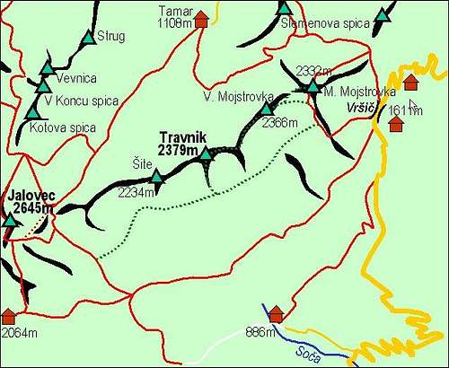
Travnik south slopes can be also accessed from SW, from the small hut, named Zavetisce pod Špičkom, 2064 m.
For a descent I don't know how would it be to find a descent down (towards south) to the marked path, which crosses the whole Dnina slopes and finally comes horizontally on Vrsic pass. Many years ago I found one hunters trail, but not south of Travnik, but more towards east, somewhere south of Zadnja Mojstrovka. Would appreciate any information!
Rating the Route (by hiking standards)
0. General. From 1611 m to 2379 m, exposition SE. First screes, then rocky and grassy landscape. From Mojstrovka S ridge on, there's no good path, perhaps some very rare marks. Normal hiking equipment (good shoes and poles), no water on the route.1. Effort. 900m, 3 h 30 min,
2. Power. 2 - easy (mainly walking, even if steep),
3. Psyche. 2 - easy,
4. Orientation. 4 - hard (take a good map).