
|
|
Route |
|---|---|
|
|
47.47890°N / 120.8322°W |
|
|
Mountaineering, Trad Climbing |
|
|
Summer |
|
|
Most of a day |
|
|
5.8 (YDS) |
|
|
IV 5.8 |
|
|
14 |
|
|
IV |
|
|
Approach
 Start
Start Descent
Easiest approach to this climb is from Colchuck Lake. To reach the lake, follow driving directions provided on main page (under Getting There) to reach the Lake Stuart-Colchuck Lake trailhead. From the trailhead, follow the Stuart Lake trail for approximately 2+ miles (the trail crosses the Mountaineers Creek on a good log bridges) until a signed junction with Colchuck Lake trail. Take Colchuck Lake trail left and cross the Mounties Creek again. After about 2.5 miles, you'll arrive at the northern tip of Colchuck Lake. Follow the main trail around the right (west) side of the lake passing a small lakelet on the right. As you exit the vegetation at the base of a boulder fan near the SW corner of Colchuck Lake (from here the trail goes on to Aasgard Pass via boulders makred wtih huge and frequently placed cairns), turn right off-trail and follow boulders and scree field (heading roughly SW) up towards the moraine at the base of Colchuck Glacier (you're essentially heading up the gully formed by Dragontail [on left] and Colchuck [on right] Peaks). Once atop the moraine, turn slightly leftward and follow the moraine (staying close to the ridge worked well; heading S/SE) towards the NW base of Dragontail Peak. The base of the climb is roughly in line with The Fin (a light colored slab feature just below the summit of route that is clearly visible from afar). More specifically, you're looking for a "black tower" about 500 feet above the ground (see Route Overview Photos below). Nelson and Potterfield give the elevation at the start of route as 6800 feet (unconfirmed).
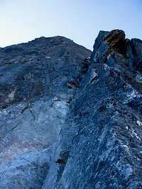
As you're looking up towards the "black tower" (which you will pass about 4 pitches up), note the righward trending ramp system on its left side. Reaching the left hand base/edge of this ramp system (which starts about 250 feet above ground) is your first goal. See photo here.
N&P below refers to route description given in Nelson and Potterfield's guidebook.
Route Description


 Crux
Crux


The route follows a prominent ridge for about 2000 feet on the NW face of Dragontail Peak to just below the summit block. The exact pitch count is not essential as the upper 2/3rds of the route are low 5th class (with some mid-5th steps) and belays can be had at any time. The rating of "grade IV" is from Nelson and Potterfield guidebook and is probably on the conservative side; class 5.8 rating comes from a single pitch! Below description is how we did this route.
Pitch 1: mid-5th class, 200 feet. Standing at the base of the route in line with the left edge of the above-mentioned right-trending ramp system (250 feet above you), look for the easiest way of reaching this ramp system. Scramble up boulders at base of route and rope up when desired. Find a left-trending gully (low to mid-5th class depending on route picked). Climb it till you're out of rope (should be before you reach the base of the right-trending ramps sytem).
Pitch 2: mid-5th class, 200+ feet. Continue over low to mid-5th terrain till you reach the left edge of the right-trending ramp system (class 4 with some steps of low-5th). Belay when you're out of rope or strech the pitch with some simulclimbing to the left-side base of the "black tower". You're now roughly at what N&P guidebook calls top of pitch 1.
Pitch 3: 5.7, 180 feet. Climb the flakey dihedral on left side of pedestal for the "black tower". Mostly low-5th with one or two moves of up to 5.7 (maybe). Belay on a large ledge at the base of "black tower". This is top of N&P's pitch 2. You can either belay on left side of black tower (per N&P or on right side of tower where you'll have a good view of the leader starting the crux pitch).
Pitch 4: 5.8, 140 feet. Climb the cracks on the face about 20 feet right of the dihedral formed by right side of tower (carck in dihedral can also be climbed as a variation at about 5.8-5.9 according to N&P; looked vegetated). We climbed a straight up finger crack (solid 5.8); N&P have a photo of a climber in an intermittent crack system about 8 feet right of what we did. Whatever works for you. Above you climb a 30-foot 5.8-ish handcrack (stellar!) just before belay ledge. Belay on a sloping ledge above, 20 feet right of an indistinct, shallow right-facing dihedral (you're about 20 feet higher than top of "black tower").
Pitch 5: 5.7+, 200 feet. Move left over low angle slabs and climb the indistinct shallow, right-facing dihedral. Terrain eases about 100 feet above. Belay on blocky terrain when out of rope. Good pitches (that's pitches 4 and 5; NOT the whole route below you) are over!
Pitch 6: mid-5th class, 200 feet. Continue up ledgy terrain till you reach the crest of the ridge (sort of the crest). Belay when out of rope. Technical challenges are over (unless you pick a harder-than-needed line). Time to focus on not killing your second with loose rocks you will be dropping (dodge-ball time!). Also realize that you have only covered about 1/3rd of the entire route length so far.
Pitches 7~14 or 16: much 4th class with intermittent steps of up to about 5.7 (again, depends on how you pick your line). You have about 8-10 pitches left to the top. Many parties will simul-climb much of this easy but loose terrain. We did a bit of this here as well but ended up pitching out again to take photos of each other on upper half. Idea is to keep to the crest of the ridge and when in doubt by-pass difficulties on the right side (left side might work as well for all I know?). The ridge broadens a few hundred feet below the summit block (which is not visible till you're a few hundred feet below). Once at the base of the block (which looks to be about 120 feet tall or so), either pick a crack system and climb directly up the face you first encounter (N&P mention this) or traverse east/left on class 3 ledges around the block till you reach the scramble/hiking way up the south side of the block.
Descent: Easy walk down is available that will bring you back to Colchuck Lake in about 2 hours give or take. As you're facing W/SW on the summit (drooling over the view you get into the Enchantments), note a faint climbers' trail heading down on the right (heading SW). Hike this trail down about 300 feet (becomes more clear lower) to reach the top of the snowfield. Turn left (heading NE) and descend the snowfield. Books claim about 30 degree snow. You're heading down in direction of a small lakelet peeping in from behind boulder field on left. Turn left, pass the lakelet and reach top of Aasgard Pass. Follow the very well cairned, steep trail down from Aasgard back to Colchuck lake. If you don't initially pick up the trail, contour down and right (staying on left side of gully will cliff you out) as you're looking at Colchuck Lake below. Endless gravel slides will bring you back to the SW corner of Colchuck Lake where you started in no time (well, maybe about 1.5 hours).
Essential Gear

Helmets! Standard alpine rack: a few nuts, a double set of cams from 0.5 inch to about 3 inch (green Alien to #3 Camalot). We had a few larger cams with us (since Serpentine was not our choice one route) which I placed but those are probably not essential.
Route Overview Photos
 Overlay 2
 Overlay 1
Web Links

(1) Serpentine Ridge TR (usual high quality work) from Michael Stanton of mountainwerks.org.
More coming when I find 'em...