
-
 4470 Hits
-
 74.01% Score
-
 4 Votes
|
|
Route |
|---|---|
|
|
46.34977°N / 13.82904°E |
|
|
Scrambling |
|
|
Summer, Fall |
|
|
Most of a day |
|
|
UIAA I |
|
|
Class 3 |
|
|
Rating the Tour (by Hiking Standards)
The grading system for hiking and scrambling routes is here.
0. General. From 1150 m to 2309 m, some ups and downs over the karst world before the West saddle. Below good marked paths, above a completely pathless, karstic terrain, with no marks, cairns or whatever. The summit ridge is sharp, exposed, the rock is lose. Gear: Good shoes and poles, for less experienced a short rope for the summit ridge. Milestones of the route: Planina Blato, 1150 m - Planina Krstenica, 1670 m - Jezerce, 1720 m - Mišeljski preval, 1995 m - West saddle, 2250 m - Škednjovec, 2309 m.
1. Effort. Cca 1200 m of altitude, 4 h 30 min.
2. Power. 2 - easy.
3. Psyche. 4 - hard, the summit ridge sharp, exposed, lose.
4. Orientation. 4 - quite difficult, especially in poor visibility.
Approach
See the parent page how to get to the end parking place in Suha valley, on Planina Blato (alpine meadow), 1150 m. On the main page of Škednjovec there are also short descriptions how to reach the West saddle from other sides. On this page, only the route over Krstenica meadow will be described in detail.
Route Description
On Krstenica
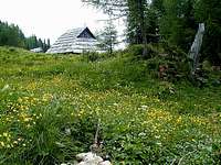
From Blato parking place, 1150 m, we continue by the marked cart-road towards the NE. Soon the steep cart-road flattens and on the place, where it starts going horizontally, we need to find the marked path which turns left, up the slope. The direction is towards the north. We first gain some altitude, then we continue walking through nice high woods. In a good hour we reach a hunters hut, standing on the edge of the abyss above Blato, offering a nice view over the high Bohinj plateau. From the hut it is very close to the first shepherds huts on Krstenica meadow. We ascend up, where from the highest positioned huts we have a beautiful panorama all around. 1 h 30 min till here.
From Krstenica, 1670 m, we continue by a well marked path towards the north. The path soon starts crossing the slopes above the valley (left below is the lower part of Dolina za Debelim vrhom), on the right the Stogi ridge begins. Between the long ridge of Ogradi on the left and Stogi on the right we walk comfortably to Jezerce meadow, 1720 m. Here is another water source (usually) and the ruins of some ex shepherds huts. From Jezerce a marked path deters right up on Jezerski preval (saddle), but we continue walking by the valley in the NW direction. The marked path goes by the left side of a small bump in the middle of the valley, the non-marked path goes around it on the right side. After some 15 minutes we already approach the big rocky barrier, which stretches ortogonally across the whole valley and closes it on the north-western side. This is the end of the lower part of the valley. Below this rocky wall a marked path connects Lazovški preval on the left and Mišeljski preval on the right - the two saddles in the crests on both sides of the valley. (A similar path goes also above the wall.) We continue by the lower path towards the right (NE) and ascend Mišeljski preval (saddle), 1995 m. From Krstenica 1 h 15 min till there.
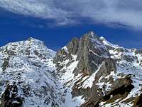
Below the S face
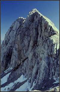
Skednjovec W ridge
Actually, for the West ridge ascent on Škednjovec we don't need to go just on Mišeljski preval. We can go also directly up the slope and so reach the upper marked path, which connects the two saddles. If we ascended Mišeljski preval, we need to go a few minutes by this path back towards the west. Here a valley, leading below the Southern wall of Škednjovec, starts. It is possible to continue by this valley, but it is more comfortable to keep left above its south-western edge. So, from the upper marked path we ascend up towards the north-west by the high edge above the valley below the South wall of Škednjovec. All the time we see the valley below Škednjovec, but on all other sides the terrain is difficult for orientation and we need quite some orientation skills to find the best passages. After passing the summit of Škednjovec, we tend towards the right, more and more in the northern direction, and finally, when reaching below Vrh Hribaric, we turn right through a shallow ravine and comfortably reach the saddle below Škednjovec West ridge, on the altitude of some 2250 m. From the marked path less than 1 h till there.
The summit ascent is easy regarding orientation - we keep as close to the ridge, as possible. But the ridge is knife sharp, rocks are loose and we must climb carefully. At first we climb close to the ridge or a bit right of it (the southern side), higher we stick just to the ridge. The upper part of the summit ridge offers just a little altitude gain, but overcomes some distance. On the summit there's some more space to breath freely and enjoy the panorama.
It is best to return down to the saddle below the West ridge and from there continue in any of the described directions. If we go by the same route (on Krstenica), we can use also some of the screes in the valley below Škednjovec's South face.