What is in this TR
The TR covers two ski trips on two consecutive February weekends to Smith Morehouse creek area of Western Uintas, a trail prepping tour and a 24-miler push for the peak.
The bottomless facets. 2/11/07
![Smith Morehouse road]() Road to S M Reservoir
Road to S M Reservoir
A February warm spell left the snow in a sore shape in Utah mountains. By the weekend of Feb 11th 2007, the avalanche report warned about "wallowing in the bottomless facets" in mid-elevations and of dangerous instability on steeper, higher elevation slopes - and even of the possibility of remotely triggering avalanches from down below. Fresh snow (at last) came with blowing winds, it just wasn't going to help things.
![Smith Morehouse Reservoir]() Across the lake in the blowing snow
Across the lake in the blowing snow
So we settled on a plan to ski up Smith and Morehouse creek, to check if the trailbreaking is as brutal as predicted, and to try to get into rolling high terrain of the S M Basin if we are lucky - but to avoid any steeps.
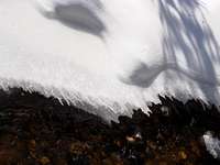
The road up Weber River was still covered by a couple inches of fresh heavy snow as we drove to the Thousands Peak gate. As usually the snowmobilers don't show as early as 9 o'clock. The 5 of us - Mike, Rob, Vince, Judy, and myself - crossed the reservoir in a blowing snow and re-assembled for a quick snack on the porch of the Guard Station.It was easy going on old tracks, but the untracked snowpack seemed ... yeah, bottomless :(
![Ledgefork GS]() Ledgefork GS
Ledgefork GS![Whew, that s some trailbreaking!]() A break from the killer trailbreaking :)
A break from the killer trailbreaking :)
Then - a pleasant surprise - we saw an old skintrack continuing along the S M trail! Of course it lasted barely a mile, still, any help is welcome :) Finally, near the Hells Kitchen junction, trailbreaking started in earnest! It wasn't quite the promised wallowing in sugary facets, but boy was it deep, thinh-deep in heavy stuff in many places. By 1 pm we crossed Erickson creek. Then, soon after the junction with Erickson Basin trail, it was time for lunch and to evaluate our options. Judy needed an earlier return, and Mike and Vince went back with her. Almost half-heartedly, me and Rob pressed on for another mile, until, at 9,150 elevation, we could see the headwall leading to up the upper S M basin through the falling snow. The terrain was getting steepr at last. The time was 2:30. I kind of hesitated to skin up now for another half an hour of this "S & M" fun. OK, let's turn back!
The ride down was quite a bit slower than we imagined, the soggy snow pulled on skis like velcro. Below the reservoir, we did a small detour through the woods, and at this lower elevation, the snow had no bottom indeed - you'd just fall through to the ground until the ski tips catch on the brush. What &^%&^$# snow! At least we've got plenty of workout though, and almost 4 miles of the hard-earned track to help us on our next adventure.
Into the heart of Western Uintas! 2/18/07
A mid-week storm was a whimp, the temperatures soared again, and the avy forecast was as ominous as before (in fact 6 people were to die in avalanches across the Intermountain states in the coming weekend).
![Sailing across S M Reservoir]() S M Reservoir: the view we missed last time
S M Reservoir: the view we missed last time![Spring is in the air!]() The warm spell carving the snow of creekbanks
The warm spell carving the snow of creekbanks
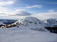
My semi-serious obsession with "Kings Peak training" was starting to kick in though. Only 6 weeks left to the annual KPT, and I like to say that you don't even start training for this high-altitude epic until you ascend at least beyond 10,000 ft. The previous weekends all fell short. It looked like our best hopes are on the North Slopes of the Uintas again, some high gentle ridge route to heed the avy warning. Maybe Peak 10,931 or, at 11,1150 ft, East Long Mountain. We've skied to its neighbors to the West, Main Long and Cone peaks, but we have never ventured so far into the heart of the Lake Country before. May be challenging given that only Rob and myself were going this time.
![Smith Morehouse Basin]() S M Basin: caught in an occasional snowtrap
S M Basin: caught in an occasional snowtrap![Cone Peak from the lakes of upper S M Basin]() Cone Peaks looms ahead
Cone Peaks looms ahead
It turned out to be a long tour indeed, approximately 24 miles RT with 3700 ft elevation gain, and we weren't back until 7:30 pm. Good weather and very good snow conditions, mostly 2-3 inches of creamy powder. We started at 9 from the little parking near the bridge, no snowmachines anywhere. Cut through the S M CG for a change, it was fall of winter-camping / snowcaving sleepy folk, crossed the lake, and started up our last week's track which was covered with on average an inch of snow. It was quickly beginning to stick, and waxed skis weren't too good for uphill sections, so by quarter to noon, we stopped for a break and skin up just across Erickson creek.
![First glimpse of the goal]() First glimpse of the peak from Island Lake Pass
First glimpse of the peak from Island Lake Pass![Beautiful Cone Peak]() Cone Peaks and Island Lake Pass behind us
Cone Peaks and Island Lake Pass behind us
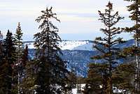
The skins slowed us down some, and the snow was getting deeper, but very soon after we passed last week's track end and dropped towards the creek bed, trailbreaking got easier. The terrain was more open and there was denser snow under the two or three inches of soft stuff, except in some nasty traps near trees. Saucer lenticular clouds hang over the mountaintops and we could see a cloudbank of the approaching storm far to the NW, and the wind, though not too strong, was picking up at spots. We hit Island Lake Pass by 3 pm and gave the situation a thought. It was kind of quiet and the blue skies still predominated, so it was like, OK, another half an hour and we decide on the turnaround then. We traversed ENE on an easy semi-open bench and in 30 minutes were greated by the gale and a jamble of snow fins at the East saddle of Long. But the wind wasn't cold, and the clouds weren't close, so we pushed on, alternating between the ridgeline and the upper South slopes, and skied to the top at 4pm (yes, it is a skiable summit, at 11,150).
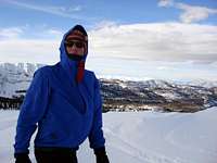
![Summit cairn is almost engulfed by a drift]() We photographed this summit cairn in October, it is no longer the highest point now :) We photographed this summit cairn in October, it is no longer the highest point now :) | ![Looking West from the top]() Looking back at the ridge we ascended Looking back at the ridge we ascended | ![Rob on East Long]() Rob Rob | |
![Lenticulars augur a storm]() Lenticulars: The storm is coming! Lenticulars: The storm is coming! | ![View North from the top]() View North towards Windy Ridge View North towards Windy Ridge | ![Looking back at the summit ridge]() Looking back at the summit ridge on descent Looking back at the summit ridge on descent | |
The weather was actually starting to improve as we turned back! The Sun was no longer behind the clouds, and the winds were dying down.
![Back at the East saddle]() Main Long Mountain towers above East Saddle Main Long Mountain towers above East Saddle | ![East Long Saddle]() Cone guards our return track Cone guards our return track | ![Mud Lake Flat]() Mud Lake Flats - view from S M Basin Mud Lake Flats - view from S M Basin | |
![North Long Mtn - South aspect]() North Long Mountain - view from S M Basin
North Long Mountain - view from S M Basin
Turning conditions were superb above 9,000, not to bad even close to the summer TH, which we reached by 6:30. A few minutes later, at the reservoir bank, it was headlamp time at last. The last section of the road below the dam was interesting, kind of like riding the waves - all frozen and bumpy - and fast.
Thanks Rob for the company, for the pictures, and for that secretly stashed Pilsner Urquell! Wasn't it one solid chunk of Kings Peak training, huh?


Comments
Post a Comment