
-
 3173 Hits
-
 0% Score
-
 0 Votes
|
|
Route |
|---|---|
|
|
40.64570°N / 75.9799°W |
|
|
Hike (Class 2-3) |
|
|
Half a day |
|
|
Walk-up |
|
|
Approach
Follow the directions in the "Getting There" section of the main page.
Route Description
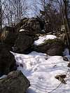
This route takes the A.T. (North) off the mountain and into the valley before climbing up to the top of the Kittatinny Ridge. You will gain over a thousand feet in elevation and this is the home of "Rocksylvania" so you'll want to have some good hiking shoes. This trail can kill your legs if you're not in shape so don' t underestimate it.
The hike up to the ridge is beautiful and much reminiscent of other places in PA except for the rocks. If you go at the right time of year you're likely to have the trail to yourself as well. From the summit ridge you'll also get the chance to enjoy som fun Class 3 scrambles. Great views abide in all directions along the ridge as well. Lookout for some feathered friends as well because you are in a prime raptor migration area. All together the hike is approximately 7 miles with over a thousand feet in elevation gain. Enjoy the hike!
6miles
 |  |  |
Essential Gear
Comfortable hiking shoes, food/water, trekking poles, and a camera.