Brand New Day
![Navajo Peak and neighbors above Lake Isabelle]() Navajo Peak and neighbors above Lake Isabelle
Navajo Peak and neighbors above Lake Isabelle
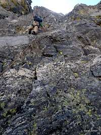
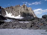
Leaving the trail-head in the dark, I had little appreciation for the scenery surrounding our team. As the sun rose, however, it revealed not only a bright, clear morning but the startling alpine beauty of the upper basin where we were headed. This Indian Peaks basin is encircled by Niwot Ridge, Navajo Peak (our objective), Apache Peak and Shoshoni Peak, and the visual effect is that of a painted canvas of color and light, where earth meets heaven.
The eastern sun warmed the mountains to a warm honey orange and the pointed profile of our day's objective came clearly into view. I savored this hour, knowing this was the more mellow element of the day. The fun and excitement would appear in due time! And, indeed, in no time, we left behind the world of plants and soil for the land of rock and snow.
![Westbound up Saint Vrain Creek]() Westbound up Saint Vrain Creek Westbound up Saint Vrain Creek | ![The team on the snow]() The team on the low-angle snow The team on the low-angle snow
|
Snowy White Wonderland
![The team on the snow]() Team starting on the snow
Team starting on the snow![Almost topping out]() Almost topping out on the Navajo Snowfield
Almost topping out on the Navajo Snowfield
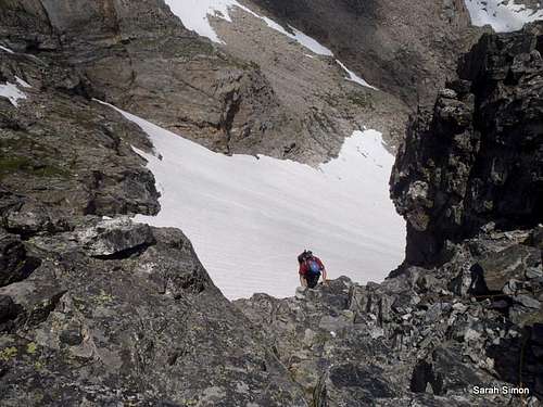
Here, at the end of July, we found large snow patches well within timberline. The snow volume increased by leaps and bounds as we headed up elevation, into the basin. In no time at all, we were all picking rocks to sit on get our crampons on our boots and our axes in our hands.
At first the angle was barely noticeable - we were walking normally, really. The crunch, crunch, crunch of metal points on snow combined with the steady breathing in the thin mountain air to set a solid rhythm for the lower-angle snow. Then the traverse toward the main snowfield began and the angle increased. Soon the snowfield had our full attention, roughly 45 degrees in angle with occasional, small ice patches. At 45 degrees, your legs gain a lot of elevation (roughly 800 feet, to be exact) in a short period of time. Thankfully, this past winter dumped ample snow in the area meaning no scree and good cramponing with minimal hard patches and no obvious major rockfall.
A Well-Earned Break
![Resting at the top of the snow field]() Resting at the top of the snowfield
Resting at the top of the snowfield![The Longs-Meeker neighborhood]() The Longs-Meeker Neighborhood
The Longs-Meeker Neighborhood
After reaching the top of the Navajo Snowfield, we took a rest, enjoyed some lunch, and got harassed by Marmots. I savored the views all around, especially those of Longs Peak and Mount Meeker. I pondered how many folks were crowded on the noble but traffic-beleaguered Longs Peak while we essentially have the north side of Navajo Peak to ourselves. The hard work of ascending the snowfield, with the heat of the sun blasting off the bright whiteness, left me literally soaked with sweat.
Time to Switch Gears
![Beginning the first North Face pitch]() Beginning our first North Face pitch
Beginning our first North Face pitch![Topping out on the 1st pitch]() Topping out on the 1st pitch
Topping out on the 1st pitch
Soon, it was time to switch gears to rock. The North Face of Navajo Peak provides a nearly limitless choice of ascent lines, depending on preference and abilities.
Our first pitch started with descent features and solid rock, though it corroded to loose choss near the top of the pitch. Three-quarters of the way up the pitch, I was worried less with finding good holds for my hands and feet and more worried about kicking down head-sized boulders on the climber below me. I sighed with relief when I reached the top and found a place to sit down where I could keep my feet still and not risk loosening rocks.
Pitch #2 and Summit
![Ascending pink granite crack]() Ascending pink granite crack
Ascending pink granite crack
A bit of easy scrambling above Pitch #1 brought us to the base of a pale pink granite cliff-band capped by a bulge of darker rock. Looking right at the band, it was obvious where we were going next!
Initially, the crack was pleasant and easy. Nearing the dark bulge, however, the foot holds began to shrink (although, thank goodness, large flakes provided solid handgrips) while the climber is forced to traverse right around the granite bulge, all the while having the dark rock band closing in over one's head. It was at this point I was reminded just how pathetic of a climber I am in my full-shank Scarpas!
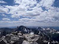
Soon enough, however, the rock-hugging exercises were over. We scrambled to the top of the mountain and relished the expansive views of mountains, mountains, mountains all around. I looked down into the "top-secret" Boulder watershed and wondered about the backpacking hippies with night-scoped paintball guns, volunteering to ping hapless peakbaggers trying to visit a forbidden summit.
![Views from the top]() Views from the top Views from the top | ![Descending from the summit]() Descending from the summit Descending from the summit |
Airplane Gully
![Pondering the Saint Vrain Creek drainage]() Pondering the Saint Vrain Creek drainage Pondering the Saint Vrain Creek drainage
from the saddle with Niwot Ridge | ![Entering the jaws of Airplane Gully]() Entering the jaws of Airplane Gully, Entering the jaws of Airplane Gully,
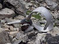
rocky and loose | ![Twisted propeller]() Twisted propeller from C-47. Twisted propeller from C-47.
Three men died in this crash. |
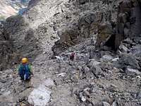
If I never visit Airplane Gully again, I won't mind. The footing is steep and loose, that classic evil mixture of scree and talus: sand and gravel to lose one's footing on, combined with rocks of all sizes, unattached to the mountain, ready to brain your climbing partner. Microwave-sized rocks totter and slide, while soccer-ball-sized rocks tumble at the slightest provocation.
More sinister yet, three men lost their lives in a plane crash here, the remnants of which are strewn about the gully. Learn more about this awful crash
here. Pardon the cliched speak, but observing the wreckage is truly a sobering experience, especially for someone who spends a lot of time in aircraft for business and leisure travel.
The Outhike
The outhike down through this scenic basin and along Saint Vrain Creek is a treat. After all the huffing and puffing and focus, it's a joy to kick back and let your feet carry you downhill while admiring the scenery, the wildflowers, the alpine tarns and the bubbling streams. My feet were screaming, and I had a cramp in the front of my right shin, but it's hard to feel sorry for oneself surrounded by all this beauty.
![Shoshoni Peak]() Shoshoni Peak Shoshoni Peak | ![Seasonal lake, mid-basin]() Seasonal lake, mid-basin Seasonal lake, mid-basin | ![End of the day]() End of the day End of the day |


Comments
Post a Comment