A Little Background
![Nevado Coropuna]() Nevado Coropuna
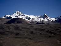
Nevado Coropuna![Nevado Solimana]() Nevado Solimana
Nevado Solimana
I have been living in
Cotahuasi for over 5 years, during which time I have gotten very involved in mountain climbing. The three main nevados (snow covered mountains), here are
Coropuna,
Solimana and
Firura. Coropuna, although it is the highest at 21,079 feet, is non-technical and fairly easy to climb. Depending on which base camp you use, there is about 5-6,000 feet of gain on the actual climb. It was the first on the three that I, and my climbing friends from Lima, climbed here. Solimana is 19,990 feet, but is much more technical, and needs lots of snow for the normal route. We have tried that two times, but both times were late in the dry season, and there was not enough snow, as well as the fact that we weren't well enough prepared for the climbs. We, along with some other climbing friends, have been talking about climbing Firura, as a training climb to get better acclimated for Solimana, as well as just because it is there and no one climbs it.
However there has never been enough time to do it, as well as they have wanted to drive to Lagunas Apalcocha, which are located at about 16,100 feet up on the high plain. It is still a day's hard hike to get to the base of the mountain, with lots of ups and downs, the last few hours of it over very rough rocky terrain. I have wanted to do it starting from my house in Cotahuasi, which is at 8,800 feet (or at least from the main road farther up the canyon), but no one else has been interested in that. I also thought it would be fun to climb it solo as it seemed like an easy (and safe enough) climb for me to do on my own. Over the last three years I have made a number of attempts to find a good route. Two times I got up to the high plain, and once even made it to the base of the mountain. Just a month ago,
climbing with Kathie, a fellow SP member, we even got to the summit ridge, before turning back due to the cold and lack of time. The snow conditions were perfect then, so I wanted to return and reach the summit before they deteriorated very much. With free time last week, I decided that the time was right, and made plans for a four-day trip. My only concern was that I had caught a cold, and I often have trouble with breathing at night on a mountain, even without a cold, because at high altitudes in the cold weather my nostrils plug up when I lay down.
Taking The Long Approach
![Looking Back Towards Cotahuasi]() Looking Back Towards Cotahuasi and Cerro Huiñao
Looking Back Towards Cotahuasi and Cerro Huiñao![Nice View But I m Too Low]() Nice View But I'm Too Low
Nice View But I'm Too Low![I Need To Go Up Here]() I Need To Go Up Here
I Need To Go Up Here![Here Is Where I Need To Be]() Here Is Where I Need To Be
Here Is Where I Need To Be
Armed with cold medicine, nasal spray, and a too heavy two person mountain tent, I set off on Monday morning, walking up the road a minute before my planned 7:00 am start (unusual!). I had debated through the weekend if I would hike from my house, or take a combi to near Alca and hike up from there, through Cahuana, as I had done on a previous attempt. Although the starting elevation is less than 200' higher, the advantage is that it is a shorter approach once reaching the high plain. However I really wanted to do it from my house, and this route would connect up with the one that we had just done a month before, so I was familiar with most of it. The Cahuana route would put me on new terrain for most of the high plain crossing. It wasn't until after 6:00 am that I finally made a decision, and sent an email to my co-workers here, telling them which route I was taking and when to expect me back.
I was feeling good even though my pack was heavier than I wanted, and in about 10 minutes turn off the road onto the trail, right at the entrance to Cotahuasi. From there it is a steady
climb up past Cerro Huiñao and the village of Chaucavilca, to a traverse along the side of Cerro Condorcina, which is on the edge of a volcanic crater. It had been about nine months since I had been on the trail here, and I got confused at a trail junction. The trail to the right seemed to climb up too much, so I took the trail straight ahead. At this point, the trail was basically a cow path, so it was hard to tell which was the main trail, but about a half hour later I realized that I should have taken the higher trail. I knew that I was too low, but couldn't see the correct trail looking up. After scanning the slopes I could finally see a line of cattle and realized that they were on the trail, heading up to a herders house on a point. Not wanting to backtrack to the missed junction, I decided to head straight up the slope until I reached the correct trail. Besides being steep and difficult, this route was covered with grasses and weeds, and by the time I arrived at the trail about 30 minutes later, I had lots of stickers in the tongues and laces of my boots. Thankfully I was wearing gaiters over leather boots, so it wasn't as bad as with my normal low, mesh hiking shoes.
Mistakes Number Two and Three
![I Thought I Needed To Go To the Trail On the Far Ridge]() I Thought I Needed To Go To the Trail On the Far Ridge
I Thought I Needed To Go To the Trail On the Far Ridge![A View Down to Locrahuanca and Up Canyon]() A View Down to Locrahuanca and Up Canyon
A View Down to Locrahuanca and Up Canyon![I Ended Up At the Wrong Pass]() I Ended Up At the Wrong Pass
I Ended Up At the Wrong Pass![Looking Down On Achambi and At Cerro Santa Rosa]() Looking Down On Achambi and At Cerro Santa Rosa
Looking Down On Achambi and At Cerro Santa Rosa
I soon came around a ridge to a large gully, and the trail made a long circle to the right to avoid losing and gaining elevation. However I could see a shortcut going straight across the gully, and it looked faster and easier than main trail, which actually went up and then came back down. The shortcut regained the main trail right where a smaller trail branched off and starting climbing up to the ridge, which was the way I wanted to go. I headed off on the shortcut and was soon on the other side and climbing up the smaller ridge trail. At this point, something didn't seem right. I could see where it reached the ridge, at a small saddle, but that spot didn't look right. I kept looking to the right and above, but there wasn't any trail doing up to the other saddle above me, which didn't look like the correct one either, so I kept going. At 12:30 I reached the saddle on the ridge, which to my dismay was not the correct place. From the ridge I needed to drop down into the broad bowl above Achambi, so it wasn't really a big deal and I quickly decided not to climb up the ridge looking for the correct saddle, only to turn around and drop back even farther into the bowl. I had been to that point a few times, and remembered a trail going down into the bowl, but had never gone down below that point. There was no trail going down from where I was, but it looked like an easy bushwhack, so after eating lunch, I headed down.
At the bottom of the bowl there was a rather deep looking canyon, so I was hoping to meet someone to ask where there was a trail to cross it. I could see where the trail I was going to went up a canyon on the other side to the high plain, but couldn't see any trail from where I was to there. There was no one in sight so I headed down the side of the ridge, reaching a canal above the canyon without any problem. There weren't any trails, or even cow paths, going down into the canyon, so I figured that there was probably a cliff there, as is often the case, (wrong guess - this would have been the best way down) and followed the canal, hoping it would provide an easy path to the stream in the bottom of the canyon. Unfortunately, the area was very overgrown and hard going, so when I reached a gully going down, I followed it. This turned out to be a mistake as there were numerous drops over boulders and steep dirt slopes, but I finally reached the bottom at just after 2:00 pm. From there I could see that I had come down one of the worst places, but other than a scrapped up hand I had made it safely. It was a steep, but otherwise easy bushwhack up the other side, and I finally reached the main trail, and was back on a route that I knew.
The Long Hard Climb Up to Camp
![A Tight Squeeze]() A Tight Squeeze
A Tight Squeeze![The Route Goes Up the Broad Draw Behind the Lake]() The Route Goes Up the Broad Draw Behind the Lake
The Route Goes Up the Broad Draw Behind the Lake![Just Before Here Is the First View of Firura]() Just Before Here Is the First View of Firura
Just Before Here Is the First View of Firura![Go Around the Lake and ThenTo the Left of the Low Rocky Ridge]() Go Around the Lake and Then To the Left of the Low Rocky Ridge
Go Around the Lake and Then To the Left of the Low Rocky Ridge![This Is One of the Last Places To Get Water]() This Is One of the Last Places To Get Water
This Is One of the Last Places To Get Water![Inca Trail to Puica]() Inca Trail to Puica
Inca Trail to Puica![Inca Trail to Coropuna]() Inca Trail to Coropuna
Inca Trail to Coropuna![Go Up the Draw In the General Direction of the Highest Point]() Go Up the Draw In the General Direction of the Highest Point
Go Up the Draw In the General Direction of the Highest Point![Base Camp Or High Camp]() Base Camp Or High Camp
Base Camp Or High Camp![A Nice Sunset Glow]() A Nice Sunset Glow
A Nice Sunset Glow
The problem was that I had expended a lot of unnecessary energy, both physical and emotional, with my wrong trails and bushwhacking. I was very tired as I headed up the steep canyon trail, still hoping to make it up to Lagunas Apalcocha before dark. I soon realized that I was too tired for that, so when I reached the grassy grazing area, I looked around for a campsite. There was one large area that was fairly flat, but it was a dirt wallow that the llamas use, so I kept looking for a grassy spot. I finally settled on a semi level, semi grassy area above a large boulder, right near of nice spring. It was not the best, but I was able to situate my tent so that I was fairly comfortable alone, it wouldn't have been fun for two people. It was also at 15,085', about a thousand feet lower than the lake, so I was hoping for a better night's sleep, at the expense of making the next day about an hour and 45 minutes longer.
I did sleep fairly well, except for a flapping rain fly which I finally properly secured during the night. I was surprised that it never got below 40° F in my tent overnight. At first in the morning it didn't look like it had even froze, but I soon saw ice in the stream and swampy area. Feeling much better than the afternoon before, I continued the climb up and by 9:00 am was taking a break along one of the lakes, before going up to the higher plateau above there. From the time you reach the high plain, the rest of the day is spent above 16,000', going up to about 16,400' on the plateau, and then up and down between those two elevations until almost to base camp. After crossing the plateau, the route drops down and goes past a couple more lakes (about two hours after the first ones), then goes around the left side of a couple of rocky cliffs on the edge of another plateau. It is a shorter route to go over this plateau, but it is very rough and there is no water up there.
About two and a half hours after the middle lakes, down in a lower area are a couple more. These seem to have the cleanest water, although I filtered all of it through a shirt or handkerchief to get rid of the little red bugs that keep swimming, in spite of the Aqua Mira treatment. On the right side of the farthest right lake, are a couple of rock shelters, and passing by them and the far side of the lake is an old Inca trail. Like most of the old trails up on the high plain, it is not made of stone paving, but by the absence of stones, or at least less stones now, as they are not maintained. They are still used, as is evidenced by the sandal and llama footprints, although I haven't seen anyone walking on it there. This one goes from Arma, near Coropuna, to Puica, according to the map. I crossed the road at 2:15, after taking a break and getting three liters of water at the lake. Four liters would probably have been wiser, I was out of water before I returned here, but not dangerously so.
There is one more small pond, about 15 minutes past here, then I didn't see anymore between there and Firura. The last hour or so is a rough climb over a boulder field in a valley, finally reaching the base of the mountain at about 16,800'. On my previous trip up here, we went up a different valley, farther to the left (north), which though it was longer, seemed to be easier. Maybe it was just because we were going a little slower. We came back on the current route, which didn't seem too bad coming down, but it sure was tiring going up. Maybe because I was tired, or just too focused on the mountain, but I missed the campsite we had used the previous trip. I finally stopped to rest and look around and saw it about 10 minutes below where I was.
At this time, I was on a very rocky ridge, but there were numerous sandy areas that were fairly flat and with few rocks. Most were out in the wide open but I found one that was somewhat sheltered between a small knob and a large boulder, and in about 15 minutes, I had a nice tent site made there, at 16,980'. Unfortunately, in spite of there being very little wind, I had a very bad night's sleep. I was having some trouble with a stuffy nose, so I took some medication which cleared that up, but I still couldn't sleep.
Summit Day!
![Time To Put On Crampons]() Time To Put On Crampons
Time To Put On Crampons![The Penitentes Are Starting To Grow]() The Penitentes Are Starting To Grow
The Penitentes Are Starting To Grow![A Little Bit of Ice, But an Easy Climb to the Summit]() A Little Bit of Ice, But an Easy Climb to the Summit
A Little Bit of Ice, But an Easy Climb to the Summit![On The Summit At Last - Nevado Firura]() On The Summit At Last - Nevado Firura
On The Summit At Last - Nevado Firura![Wait a Minute, Is That Peak Higher?]() Wait a Minute, Is That Peak Higher?
Wait a Minute, Is That Peak Higher?![A Frozen Dragonfly At 18,000 feet]() A Frozen Dragonfly At 18,000 feet
A Frozen Dragonfly At 18,000 feet![Some Crevases On the East Side]() Some Crevases On the East Side
Some Crevases On the East Side![Lower North Peak]() Lower North Peak
Lower North Peak
It was colder than the previous night, below freezing as soon as the sun set, so I was thankful that I had brought the mountain tent, instead of my Tarptent, which is single wall with lots of mesh. I think the coldest it got in my tent was 35° F, so I was plenty warm during the night. I had my alarm set for 5:30 am, but was finally dozing when it went off, so I shut it off and went back to sleep, and got up about 6:15. I had decided that I wasn't going to start until the sun was shining because I didn't want almost frozen hands again. I had set up my alcohol stove just outside of the vestibule, so was able to make tea and oatmeal while sitting inside the tent.
Just about the time I was done I could see the sunshine hitting my tent, so I got out and was on my way at 7:07. I was surprised at how much less snow there was than just less than four weeks earlier. I took a slightly different route up, and reached the first snow patches in just over 30 minutes. I still had to walk on some rocky sections so I waited until I reached solid snow before stopping to put on my crampons. As was to be expected, the snow was very firm, but not very icy. However the penitentes had already started to form, there weren't any the previous trip. Thankfully they were only four to six inches high, and were not difficult to walk on. Some places were better than others, and by 8:30 it was mostly smooth, and was easy walking the rest of the way up to the summit. Near the summit there was a little smooth ice, but it was just a thin layer on top of the snow, and crampons easily broke through it and footing was excellent. I did not have an ice ax with me, but did use two trekking poles, and was never in any danger of sliding. I would not have wanted to do it in the morning without crampons, it was fine without them in the late afternoon on the previous trip.
I did a little zig zagging this time, but mostly went straight up a broad ridge towards the rounded summit, and then straight up that. Because of the rounded top I couldn't see the summit until I was almost on it (and my altimeter watch showed low), so was very surprised when I looked up and realized that I was on the summit! It was 8:50 am, an hour and 43 minutes from camp. My joy was temporarily shaken though when I looked towards the southeast and saw another peak that looked about the same height as the one I was on. There was a steep ridge running down and then up to that point, with a sharp drop off to the south into a large crevasse. At first I tried to assure myself that I was on the true summit, but it was such a beautiful day up there, and I had plenty of time, so decided to go check it out. I reset my altimeter to 18,038' and went down, over and up to the other peak. Whoo hoo, it was 17,999', I had been on the summit!
After taking some photos, I headed back up to the summit. On the way, I stopped to take a photo of the ridge and saw something in the snow. It was a dragonfly, that looked like it was frozen in flight at 18,000'! After getting my summit photos, I thought about going to the lower north summit, but decided that it would be wiser to head down. In spite of a leisurely break while I took off my crampons, I was back at camp at 10:37, three and a half hours after leaving there.
The Climb Isn't Successful Until You Get Home
![Lower Campsite]() Lower Campsite
Lower Campsite![On the Return, Aim for the Two Little Points on Top]() On the Return, Aim for the Two Little Points on Top
On the Return, Aim for the Two Little Points on Top![Follow the Gully Down]() Follow the Gully Down
Follow the Gully Down![A Frosty Morning at the Lower Lakes (Alpalcocha)]() A Frosty Morning at the Lower Lakes (Alpalcocha)
A Frosty Morning at the Lower Lakes (Alpalcocha)![Finally Back on the Trail and Heading Down]() Finally Back on the Trail and Heading Down
Finally Back on the Trail and Heading Down![There Are Only a Couple of Good Places To Cross This Gully]() There Are Only a Couple of Good Places To Cross This Gully
There Are Only a Couple of Good Places To Cross This Gully![He Must Have Slipped!]() He Must Have Slipped!
He Must Have Slipped!![Back Home and Very Happy]() Back Home and Very Happy
Back Home and Very Happy
I had been a bit apprehensive before starting the climb, as this was my first solo summit of a snow covered mountain (although I have been higher before by myself on Solimana, just didn't try for the summit), but I was feeling on top of the world now, and didn't want to go back down. Knowing how rough the descent would be probably had something to do with it too! I celebrated with my last three circus peanut candies from my U.S. visit earlier in the year, and slowly packed up, taking almost an hour before I was ready to leave.
On the way down I checked the lower campsite, it was 16,870', and I set up a couple of carrins to mark it. Because I was out of water before I got back to the lakes at 1:35, I used my straw filter to drink, instead of waiting for the treated water. I would have liked to have reached the same lower campsite I used on the way up, but soon realized that that would make too long of a day. At 5:30 pm, just before dark, I reached the far side of the lower lake, and camped there at 16,090', rather than go another hour and a half to the lower site.
That night was another bad night's sleep, this time I was not able to get my stuffy nose to clear, and it was the coldest night so far (which probably affected my nose). It was right at 30° F in my tent most of the night. After again waiting for the sun in the morning, it was 7:30 before I started hiking. I stopped at the spring by the lower campsite for water, and then hurried on to the notch above Achambi to look for a trail back up to the correct pass on the ridge. There wasn't any trail in sight, even though I could clearly see where the trail came over the white rocks on the ridge. I headed down and found a much better route to cross the canyon, and then set out directly for the pass. Again I didn't see anyone to ask directions from, even though I passed a couple of herder's houses. I did find a few paths, which I followed as long as they were going my way, and reached the pass without much difficulty at 12:50 pm.
I had a long lunch there, soaking up the warm sun, now that I was at only 13,860 feet. On the way down, I saw where I had gotten mixed up on the passes – my shortcut had taken me to the wrong trail, which I hadn't noticed on the way up. I reached the good trail at Chaucavilca at 4:00, knowing that it was only an hour or less from there down to my house. By now I was hot and tired, (I should have changed into my shorts at the pass but I didn't), so I slowed down a bit to make sure I didn't stumble and fall going down the many steps on the trail. At 5:01 pm I was setting my camera on the steps of my house to take my 'end of trip photo', three days and 10 hours after I left, and was one tired, but very happy, camper.
Comments
No comments posted yet.