|
|
Route |
|---|---|
|
|
37.98885°N / 107.7477°W |
|
|
Hiking, Mountaineering, Scrambling |
|
|
Spring, Summer, Fall, Winter |
|
|
Most of a day |
|
|
Class 3 |
|
|
Overview
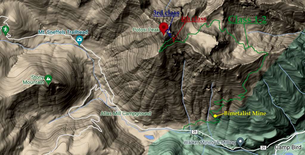
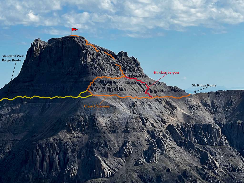
Potosi Peak is the third highest peak in Yankee Boy Basin (Mt. Sneffels & Teakettle Mountain are higher). There is absolutely no way to ascend this peak without encountering [dangerouly] loose scree/talus and at times, challenging route finding. As Liba's great main page points out, there's three possible routes to the summit (one of which is strictly a seasonal route). The Southeast Ridge/South Face is an alternative option to the western approach.
Both the Western Ridge (via "Coffeepot") and the Southeast approach (via Bimetallist Mine) join and connect on the South Face. However, WHEN these routes join up is more or less up to the climber depending on which preference they choose as the Bimetalist approach has two options: a class-2 traverse that avoids the cliff bands and a 4th class 'cut-through' ramp that exits directly at the bottom of the South Gully. Both options will be detailed here.
As the western approach offers constant views of upper Yankee Boy Basin and Stony Mountain (12,698') just across the valley, the Bimetallist approach doesn't offer much for views in the beginning as the trail switchbacks through the thick forest. Past treeline and in Senator Gulch however, the views are astounding, better in my opinion than the standard approach.
This approach also avoids most of the loose scree and talus for the majority of the route as 70% of it lies on a class-1 trail; hard to argue with that! While the trailhead is at 10,410', the wonderful trail will disappear once you gain the apex of the southeast ridge at 13,220'. But again, even though this route is longer, it is easier and in some regards, safer. The possibility for calamity on this mountain is high. So tread carefully and test EVERYTHING. Even the stationary, solid rock is covered in "kitty-litter" and ball bearing scree (much like Dallas Peak).
Getting There

From the small, mountain town of Ouray, take Camp Bird Road #361 (signed off hwy. 550) west. This road travels past the Ouray Box Canyon/ice park (via ferata in the summer). Drive for 5.9 miles west on this VERY popular dirt road into Yankee Boy Basin. At mile 5.8/5.9, look for an unmarked side road on the right. This is the trailhead. Park on the main road #361 off to the side. You can only drive a few hundred feet up this spur before an avy path/washout cuts across the road. Plus, there is a gate blocking the way. The elevation is 10,410'.
Make sure to roll up the windows before departing (dust). Yankee Boy is immensely popular with the 4x4 crowd as destinations like: Sneffels, Govenor's Basin and Imogene Pass are accessed from here.
Route Description

This route gains roughly ~5,900' in 8.31 miles...utilizing the 3rd class by-pass and class-2 traverse for the decent.*
Approach
From #361 (Yankee Boy Road), leave the car and walk up the spur road. This spur does not have a name or numerical designation attached to it. It starts out wide but after a few hundred feet, becomes impassible by vehicle due to a avy/water run out and a closed gate. The road past this is strewn with rock and small saplings and will end in a small but secluded clearing (great for camping).
To hikers left, veer up the small embankment to an unmarked trail (look for a cairn) and continue eastward on the primitive grassy trail.
For the first 1.8 miles, the trail switchbacks frequently though sloped, dense forest. It's easy to follow despite there being a lot of downed trees crossing the trail. At mile 1.3, the main bunkhouse of the Bimetallist Mine is encountered. There's a small, partially open horizontal shaft a short ways before the bunkhouse and the main shaft past the cabin in a clearing. It's worth stopping for a bit to check this out.
At roughly mile 1.8, you'll break free of treeline and contour straight up a shoulder. There are two small cairns I built to better mark this ascent and several more on the long traverse. After 80'-100' or so, the trail will dogleg right and start traversing across the top of two unnamed drainages. Follow this to the edge of Senator Gulch. Once on the spine of Potosi's eastern shoulder, the views across Senator Gulch are astounding!! The trail's consistency is that between a well-trod game trail and a primitive social trail.
Follow the track down into Senator Gulch losing elevation as you do so. The trail will disappear completely once at the bottom. The goal is two flat benches (one at 12,400' and one at 12,800') below Potosi's northeastern aspect. Your route will wrap around slightly hikers left then ultimately south higher to a dry tarn. It is here you can see the last segment of the class-1/2 approach.
Climb the scree slope directly south to the top of the ridge. From below, it looks absolutely miserable. But once you start ascending, it's actually not that bad. It is more stable than it appears. At the top of the ridge, there's two cairns and a couple of surveyor markers I propped back up. This is a great place to take a break as everything else beyond will get dicier.
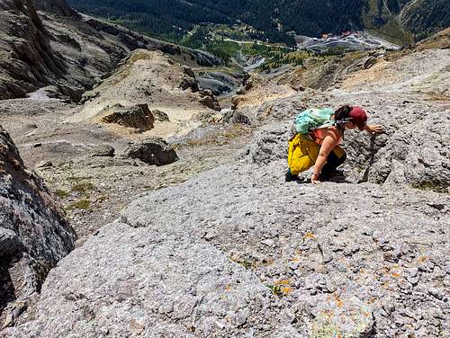
Scramble
Continue side-hilling across the Southeast Face on a very scant social trail for roughly ~500 feet. Keep looking uphill during this traverse. While many of the cliffs and short gashes through the cliffs seem climbable, those gullies are going to be 4th and 5th class on unstable, loose rock/boulders. The cliffs themselves, while more stable, are composed of crumbly pink granite and I believe quartzite covered in "kitty-litter" and pebbles. Any fall or slide will drop you 20'-40' back down onto the slope and of course, sliding down to MUCH steeper & larger cliffs below. This is kind of a bad place to go exploring.
There is a 4th class cleft about ~500' along the traverse. I built a decent cairn marking this gully on top of a large boulder. The slope is compacted dirt with pebbles at this location. There are three options at this point.
- Climb the 4th class gully direct for ~50'. Take care at the large boulder/chockstone 30' up to not dislodge it. It's fairly stable but does wobble. Climb the right side against the gully wall and continue up gingerly scrambling over it. The scrambling drops to 3rd class with looser talus in the gully. After a short 20', you'll pop out onto a wide and flat bench/ledge with the main southeast gully directly above you.
- Look slightly to the right (east) of the gully. There is a 6"-8" green, grass covered ledge heading up at a 45°angle. Climb this exposed ledge to the base of a 3rd class granite bulge. There are plenty of SMALL holds situated all along the rock. Just brush off the pebbles & kitty-litter for more secure footing and grip. Climb this bulge while heading to the right towards an obvious short & shallow cleft. DO NOT FALL HERE. While the scrambling is only 3rd class, the consequences of a fall will be very dire. Climb the short gash/chimney for 10' and angle left onto exposed but better holds. Another 6' and you'll be on that same flat, broad bench referenced above.
- Bypass the first two options and take the class-2 traverse all the way to the southwest corner. This traverse looks very long but there is a scant social trail that'll make it quicker. Once at the southwest shoulder, scramble up the short, crumbly rock cliffs weaving through them (class-2+) to the talus above and traverse back the direction you came to that same flat, broad ledge that leads to the southeast gully. You are now on the standard approach trail. Cairns are few but keep traversing. When you hit the gully, you'll know it. It's open-faced and marked by a couple cairns.
At this point scramble up the gully and eventually contour climbers left. The rock is staggeringly loose and of all size. Just follow the cairns if you get lost. The terrain is confusing and very pareidolic. Do not scramble this gully all the way to the ridge. Roughly 3/4 the way up, on the left, there will be a set of cairns side by side separated by a water run-off channel. Climb out of the gully to the left onto easy ledges. There will be a few more cairns.
At this point, you're only a couple hundred feet from the summit. Follow the cairns and social footprints left from previous hikers trying to stay to the right. If the scrambling gets class-3 or harder, you're off-trail. Again, everything is covered in kitty-litter and pebbles. The scrambling can be fun here but don't fall. It's a long, skin-abraising slide down. Potosi is a long & rewarding summit.
* I don't recommend descending the 3rd class by-pass. While the climbing is only 3rd class, the consequences of a fall will be indicitive of something 4th or 5th class.
Essential Gear
I don't normally recommend bringing a helmet on a class-2 or class-3 route. But of course, the rock quality will dictate that. On Potosi, regardless of what route you end up doing, I recommend bringing a helmet. Small falls, slides and rockfall are likely on this mountain. A friend of mine took a major slide on this mountain. So, protect your noggin. Having a pre-route in your phone or GPS would be helpful for the upper mountain and bring boots, leave the trail runners at home.
External Links
![]()
Mike's (Boggy B's) 14ers.com description
13ers.com (Climbing Cooney's)
![]()
Labeled Overview