
|
|
Route |
|---|---|
|
|
36.78230°N / 118.479°W |
|
|
Technical rock climb |
|
|
Most of a day |
|
|
lll 5.7 |
|
|
Approach
From the west: (Bubbs creek) Hike up the use trail on the west side of Charlotte creek, then up the slabs to the base.From the east: (Kearsarge pass) Follow the trail along Charlotte creek downstream until close to the dome. Hike up the slabs then conture around to the base of the south face.
 |  |
Route Description
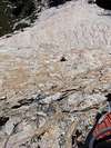
here is a photo showing the route. There's multiple variations, the South face has lots of features and lots of ways to go. Follow the path of least resistance. The climb can be done in 8-11 pitches depending on length of rope and pitches. There are very few rappel anchors . If you want to rap be prepared to leave gear. Always bring extra slings on backcountry routes. The S. face route can be climbed as quick as 2 hours for fast parties, Most take less than 8hrs. but slow parties may take all day.Chris McNamara's book, High Sierra Climbs. has good beta and a detailed topo.
~~~~~~~~~~~~~~~~~~~~~~~~~~~~~~~~~~~~~~~~~~~~~~~~~~
This route descrition provided by Eric O.
This route is not for those who get disconcerted or annoyed at having too many choices to make! But if you're willing to just go for it and pick a line as you go, it's uniquely rewarding, always giving up super classic sequences that weren't visually apparent until you get to them.
Summary:
Start at highest tree on the lowest-angle buttress available, pick best line upward from there; when good crack system runs out, follow super pink dike up and right for a long way until you begin to confront the Furrows; climb a Furrow, then aim for the Hanging Gardens above; after that it's easy.
Unabridged version:
First take a good look at the existing route photo and/or any additional ones that get filed here.
Contouring around the base of Charlotte Dome, you go a little past the point of being due south of the summit. What you're looking for is where the dome has a foot/buttress that sticks out and creates a lower-angled way to go, compared to steeper areas to either side of it.
The starting point is unmistakeably marked by one large pine tree that stands apart from any others, plus one smaller pine directly uphill from the first pine. If you look up from here you see many crack systems. Many of them are good, but if you pay close attention to the ones you choose, you'll see the telltale signs that climbers have passed by before: a little wear on the flakes, less lichen on footholds, and if you're lucky (or not) you might see a touch of chalk on the knobs.
Even if you can't find any sign of which crack system seems right, once you've started from the trees, you pretty much charge (carefully) uphill. Any time your line turns out to be less than the best choice, you get to either make a 5.9 traverse move or two to a better crack, or back up 10-15 feet and fix your mistake.
In case it helps you to look five or six pitches ahead and make a mental note of where you're aiming for: as you are climbing the first two pitches of the route, the middle pitches are seen as the right skyline far above you.
The first couple pitches grow progressively steeper, then the angle lessens for a short distance and there is an area with more relief (more cracks, blocks, and alcoves) than there was below. Above this the dome steepens again. Leave this rest area by following an amazing, excellent quality pink dike that creates an avenue of positive knobs and pockets up through otherwise difficult rock. Follow this pink dike as it diagonals up and right for quite some distance.
In fact you want to follow the pink dike all the way to where "The Furrows" become obvious. This is the point where the rock gets a lot steeper, as steep as it's going to get on this route. You'll see this above you, and that's about the time you pick a place to leave the dike behind and choose which crack to take you through The Furrows. The choice is not too difficult to make if you look straight up to find one that looks obviously closer to 5.7/5.8 while the other alternatives appear less featured and/or steeper.
Up you go through your chosen Furrow, which turns out to be less difficult than its intimidating looks, if you picked a good one. Immediately above this, the angle lessens; nonetheless this is where you find the crux of the climb as your crack system runs out and you're forced to climb face holds only. This will be 5.8 in places, though there might be a 5.7 alternative hiding in there somewhere.
About this time, you can see upward again (because the angle lessens above the Furrows), and you'll notice an area of vegetation growing out of the rock some distance above you. Aim directly for these "hanging gardens" and in fact climb either through them (in cracks and knobs on a fun arete) or just around to the left of them (wider cracks, offwidth/chimney, pockets).
After the vegetation, there's an enormous bivy & rest area. Walk over and check out the amazingly pocketed granite just east of where you arrived. Rest a bit then continue either directly upward to the summit on all sorts of fun features, or if you're tired of thinking with your hands, head a little west for the easiest route to finish.
From the summit (surprisingly narrow for a dome) the descent route is obvious. It's 3rd class but a short section could be 4th if it's raining (lots of black lichen).
~~~~~~~~~~~~~~~~~~~~~~~~~~~~~~~~~~~~~~~~~~~~~~~~~~
First ascent: Galen Rowell, Chris Jones, and Fred Beckey
October 1970
 |  |  |
Essential Gear
One set of Cams up to 3.5"One set of Stoppers.
Lots of slings.
A 60 meter rope is useful, but a 50 meter works.
asmrz - Dec 16, 2004 2:16 pm - Voted 10/10
Route CommentIn mid to late March 1992, Rich Henke, Nancy Jensen, Peter Green and I skied to Charlotte Dome from Onion Valley and in full winter conditions (after recent storm), climbed the South Face. The climb was great, the descent took everything out of us. Many rappels off trees down slabs, that in summer were easy walk caused us to get back to the base next day in the early morning. Same day ski out followed. The route is extremely suitable to late winter ski/climb combination. Ours might have been First Winter Ascent. Alois Smrz.
Eric O - Aug 7, 2005 2:56 am - Hasn't voted
Route CommentNot all, but many of the cracks on this route have a lot of taper. Hybrid Aliens, if you have them, could be really welcome.
dsquezly - Sep 18, 2014 2:55 pm - Hasn't voted
12 Sep 2014Hi, I climbed this great route a few days ago. We approched from the OVT and found the route from Charlotte Lake well marked and well traveled. The route itself was very fun, definitely run out in places but it was on fairly moderate terrain. The walk off the back was a little sporty but there were two rap stations that helped. There was another party that passed us on the climb so if you left anything on the route let me know, we probably picked it up.