
|
|
Route |
|---|---|
|
|
52.04975°N / 117.31236°W |
|
|
Mountaineering |
|
|
Summer |
|
|
Most of a day |
|
|
II |
|
|
Overview
This is the standard ascent route on Mount Bryce. It has the advantage of having the shortest approach for all routes if done from the Bush River logging roads. The approach hike to the south glacier camp takes most parties 6-8 hours. From the south glacier camp (7700') it is another 3700 feet of elevation gain up the south glacier and then the south face to the main summit of Bryce. Optionally one could climb the Centre Peak from the col between the main peak and center peak. Climbing the center peak is fastest when dry. Some claim ascents in just 30 minutes from the col! When snowy it is more likely to take 1-2 hours to ascend from the col.Getting There
The climb starts from a campsite/bivy at the base of the south glacier. There are a few established tent sites (rock rings) here.Route Description
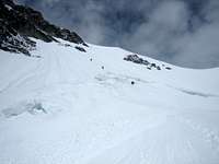
 Lower South Glacier
From the bivy site, ascend up the left side of the scree/talus slope (not the glacier). By staying on the talus slope you are bypassing a fairly crevassed section of the south glacier. At some point you will leave the talus slope and cross right onto the glacier avoiding crevasses. When we climbed this route in August of 2006 there was a very large runnel in the center of the glacier. We crossed under the runnel moving to the right before the slope was very steep. We came to a small bergschund crossing which we crossed on the far right side near a rock wall.
Above the bergschund crossing the slope gets and stays steeper (35-40 degrees). It is best to stay on the right side of the glacier, outside of the runnel, since the left side gets early morning sun and if temperatures are warm this will cause various debris to come down the left side and the runnel. (you can watch stuff roll down on a warm day) The center runnel was quite deep in August. We were able to stay to the right, on an elevated snow arete (rock fall less effected this area unless they were knocked down by other climbers). There could be various chunks of rock embedded in the glacier on the climb up. If there has been no recent snowfall, or if climbing later in the season, then large sections of the south glacier could have lots of embedded rock and talus which has apparently fallen from above. (unpleasant) The embedded rock dulls crampon points and is difficult to avoid. Downclimbing this section is also tedious as proper foot placement can be challenged due to the uneven nature of the glacier's snow/rock/ice surface. If earlier in the season the rock may be mostly buried and the climb may be more snowy. I would worry about avalanches on the south glacier if the snowpack is not consolidated. It seems like a prime/perfect angled slope for avalanches. At the top of the South Glacier (about 10700') you reach a saddle/col of sorts.
From the south glacier saddle you have two options depending on conditions. You can climb the south face of Bryce directly, probably crossing over a bergschund (45-55 degrees) or you can walk over more moderate slopes to the col between the Bryce's main and center peaks.
SOUTH FACE DIRECT
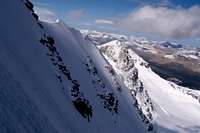
 South Face
The south face is much more direct and if conditions are good it will likely be the fastest route to the summit. Be wary of avalanches and wet slides on the sunny south face here. If climbing the south face, go straight up over the berschund under some rock faces above. A little rock protection could be useful if belaying the face, otherwise snowpickets and possibly ice screws are useful. Climb directly towards the rock face, then go right up and around them. Then start going up and left. The steepest part is near the top where the snow/ice slope is near 50-55 degrees. Right below the summit, in August 2006, the angle eased off considerably.
 Summit cornice
For the descent in stable conditions it is possible to just downclimb the south face directly, however it is somewhat steep and one must be careful when downclimbing above the bergschund. Some parties may want to rappel the first couple pitches. If rappeling all the way back over the bergschund it is about 4-5 rappels. It is easiest to use (or set) rappel stations on the adjacent rock walls. Otherwise v-threads or snow bollards can be made. At least some of the rappels can not be done from rock-based anchors.
NORTH EAST RIDGE FROM COL
 Northeast Ridge
From the Col, it is possible to climb snow and rock along the ridge directly to the summit of Bryce. I have not climbed this way previously so this description is paraphrased from what I've heard. This route is most likely best when the snow has melted back considerably allowing for more rock scrambling. Some of the climbing is likely quite exposed. The rock climbing is probably about Class 4 in spots, so a rope and protection may be desirable in spots. Near the summit the route is snow, and you are traversing on a snow ridge with dropoffs on both sides. The left side drops off towards the glacier below (45-55 degrees), whereas the right side is the north face of Mount Bryce and is quite a steep drop off.
To descend reverse the route back to the col. If conditions for climbing the ridge are good, you may want to climb the Center peak from the col as well.
Essential Gear
Standard glacier climbing gear: two 60m ropes, snow pickets, a few ice screws, helmetPossibly some rock protection (nuts, tricams)
For rappelling: v thread tool, webbing, cord, etc.