
|
|
Mountain/Rock |
|---|---|
|
|
32.36723°N / 106.57817°W |
|
|
Dona Ana |
|
|
Mountaineering |
|
|
Spring, Summer, Fall |
|
|
8130 ft / 2478 m |
|
|
Overview
The Organ Mountains are quite a spectacular sight when viewed from the southern New Mexico city of Las Cruces. They rise up abruptly from the foothills and quickly reach heights of more than 5000' above the city that lies just a few miles to the west. The Organs are a small range of mountains that lack a large footprint, but they more than make up for that deficiency with a vertical presence that can't be ignored. The SRE is on the right in this photo
 The Rabbit Ear group as seen from Aguirre Springs BLM Camping Area. The SRE is on the left in this picture
The South Rabbit Ear (SRE) is a spectacular rock tower that looms over Las Cruces, NM and White Sands Missile Range. It lies in the small Organ Mountain Range and is rarely climbed despite its' proximity (~10 miles) to the medium sized city of Las Cruces. It's a member of the Rabbit Ears trio and is often overshadowed by its taller and more rugged brothers (North and Middle Rabbit Ears).
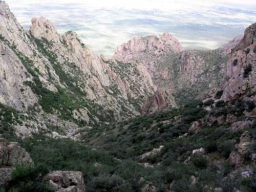
 The SRE as seen on the approach
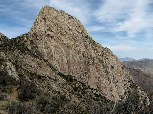 The South Rabbit Ear as viewed from Big Windy Canyon just to the south of the peak.
Despite being the shortest of the three Rabbit Ears the South Rabbit Ear offers some great climbing and scrambling options. It's also the only one of the three to have a non-technical route to the top. The NW Face Route has a bit of exposure and few interesting moves, but nothing should be more difficult than Class 3. This route (and peak) was first climbed in the mythical days of y'ore by the group of German scientists that were transplanted to White Sands Missile Range following the end of WWII.
 The SRE with the "Old Man" looking on
Getting There
There are two primary methods of approach to the SRE. The best way to approach an east face route is likely from the Aguirre Springs BLM recreational area, but there is no trail and the bushwhacking may be severe. The primary approach used for all of the other routes is via the Topp Hut Mine and Rabbit Ears Canyon.To access the primary approach take US 70 east out of Las Cruces towards Alamogordo. Take the NASA Rd / Baylor Canyon exit that is the last highway exit before reaching San Augustin Pass. Head 3.9 miles south from the exit on US70. At this point you'll pass a cattle guard and see a primitive dirt road that heads toward the mountains. Pull off here, and decide how long you would like to punish your vehicle as you drive east towards the mountains. IMHO, it's best to park passenger cars and other lower clearance vehicles right off of Baylor Canyon Rd where there is some parking room.
 The Rabbit Ears Canyon must be ascended before gaining the steep slopes of the SRE
 The upper slopes of the SRE offer some fun 3rd class climbing
Weather

Camping
Typical BLM camping restrictions apply. There is a pretty cool spot along the route just as the trail enters the Rabbit Ear Canyon. The spot is pretty obvious and has two nice level areas as well as a small windbreak.External Links
Online Organ Mountain Climbing GuideParting Shot
 The view towards the peaks from near the parking area.