
-
 10273 Hits
-
 0% Score
-
 0 Votes
|
|
Route |
|---|---|
|
|
32.42440°N / 92.8965°W |
|
|
Hike |
|
|
Less than two hours |
|
|
Class 1 (Walk-Up) |
|
|
Approach
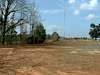
The main trailhead is located at the Mt. Zion Presbyterian Church, however, it is possible to start at lower elevations near the various road intersections in the area. A convenient choice for those wishing to double the route length and increase the vertical gain (4.8 miles; 361 vertical feet), is to continue West from the church parking lot until reaching the intersection with Jot Em Down Road. There is a small pull-out on the Northeast side of the intersection that has space for 3 or 4 cars. From this point, Louisiana's 3 highest named summits are all accessible.
 |
Route Description
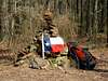
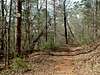
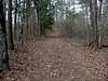
The standard route up Driskill Mountain begins at the Mt. Zion Church. (If starting at one of the trailheads along the road, simply hike the length of the road to the church parking lot and join the main route from there.) Begin by hiking generally N along a dirt road that contours to the climber's left of a radio transmitter. Dip down into a barely noticeable saddle, and avoid taking the NE fork of the trail. Continue by going NW up to a saddle, passing a trail leading due N to a false summit, and then go down the main trail to a fork at 134m (440ft). Take the right branch of the trail which meanders N up to the 163m (535ft) summit. A quadrant survey marker is about 20m north of the summit. The logging that has gone on over the years has produced several side roads that can easily confuse someone without a map and compass. There are signs at every trail junction, but still be prepared to navigate for yourself.
 |  |  |  |
Essential Gear
No special gear required.
Miscellaneous Info
If you have information about this route that doesn't pertain to any of the other sections, please add it here.