
|
|
Route |
|---|---|
|
|
39.68310°N / 106.2936°W |
|
|
Hike |
|
|
A long day |
|
|
class 2 |
|
|
Approach
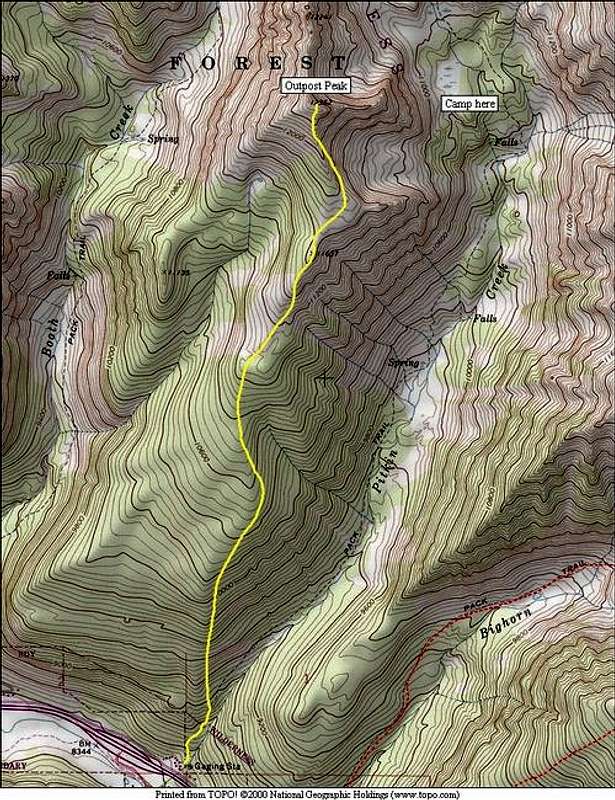
6 miles RT and 3,800-ft
The following is a winter route description, there may be a trail in the spring/summer that takes a different route but this is the safest winter route. Bring snowshoes or skis, otherwise you won’t make it to the summit.
Starting at the Pitkin Lake Trailhead at 8,470-ft, locate Outpost’s steep, aspen-laden lower slopes just to the northeast (left.) Snowshoe the Pitkin Lake Trail for about 1/3 of a mile and 400 vertical feet. Leave the trail and ascend the steep slope and gain the rounded ridge crest of “Outpost’s” south ridge. Begin the steep ascent, hopefully the snow here will be hard from prior sun or you may be in for some tough potholing. At 10,200-ft the slope will level out a bit in the pine trees. Continue directly on the ridge as the crest begins to narrow and take on the form of a real ridge.
Route Description
Reach tree line at 11,000-ft and continue to ascend up to point 11, 637-ft. From here you get a pretty good view of the rest of the route. The summit may seem far away but in reality it is .70 mile away. From 11,637, the ridge will flatten out and you will have to negotiate some deep snow. At 11,747-ft stay to the far right of the south ridge, and continue up the wind scoured south ridge to a false summit at 12,300-ft. From here the ridge bends directly west for about 100 yards to the summit. Do not stray from this route, obvious avalanche danger is present on the southwest slopes of this mountain.
Descend your ascent route.
Essential Gear
Snowshoes or skis, trekking poles, topo map and the normal array of clothing for a winter climb.
Miscellaneous Info
If you have information about this route that doesn't pertain to any of the other sections, please add it here.