
|
|
Route |
|---|---|
|
|
43.73610°N / 114.099°W |
|
|
Hike/Scramble |
|
|
Most of a day |
|
|
Class III-IV |
|
|
Approach
To access Big Basin Peak's South Ridge Route from Hailey, Idaho, drive north on Highway 75 for 7 miles until reaching the East Fork Road. If coming from Ketchum, drive south on Highway 75 for 7 miles until reaching the same road. Turn east up the paved road and drive through many subdivisions.
Follow the road through the old mining town of Triumph until the road becomes dirt. Continue up the main East Fork of the Big Wood River as the road splits at Hyndman Creek. Follow the road past Sawmill and Federal Gulch Campgrounds. The road deteriorates in condtion after the campgrounds and a four-wheel drive, high clearence vehicle is needed. Drive 4 rough miles to the trailhead for Johnstone Pass.
Route Description
Route Stats
From the Johnstone Pass Trailhead, hike 1.5 miles upstream along the base of Jacqueline and McIntyre Peaks until the trail begins to turn east and head toward Johnstone Pass.
Leave the trail and travel cross country to the base of a typical Pioneer Mountain, high basin, wall of slabs and mixed evergreen. Follow the draw staying near the stream for about 1,000'.
Turn west at 10,000' and hike to the saddle northwest of the Little Matterhorn. Drop a few feet into the basin immediaetly below Pt. 11,020 and Big Basin Peak. Continue north about .5 miles until reachin the 10,400' contour line.
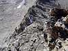
At this point, two notches in the rugged south ridge are visible. Ignore the lower, easier looking notch, and aim for a ledge the runs to the west in the lightly colored rock to the second higher notch.
Take the small ledge to the notch on the south ridge. Drop to the west side of the ridge to avoid rock towers. The next 600' is solid class III climbing with several viable routes. It is best to stay on the west side of the south ridge when possible. The crux is just below the summit where the face and ridge steepen considerably and the terrain borders class IV climbing.
 |  |  |
Essential Gear
All that is required is some experience with route finding and scrambling. A rope is not necessary.
Miscellaneous Info
If you have information about this route that doesn't pertain to any of the other sections, please add it here.