
-
 3313 Hits
-
 76.47% Score
-
 7 Votes
|
|
Route |
|---|---|
|
|
34.27080°N / 118.104°W |
|
|
Scrambling |
|
|
Spring, Summer, Fall, Winter |
|
|
Half a day |
|
|
Class 2 - Scramble |
|
|
Overview: Steep and Yucca -Choked
This is a challenging alternative to the main West Ridge route. It may not be to everyone’s taste though. The route is very steep with lots of loose dirt and lots of brush to negotiate, and so it is classified a Class 2 scramble. It is likely more commonly used as a descent route after having come up the West Ridge, than one of ascent, but it is challenging either way.A round trip on this route is 2.75 miles with 1,300 feet of gain from the Red Box Ranger Station trailhead. Short but memorable.
Getting There
From the 210 Freeway, exit at Angeles Crest Hwy (SR 2) and go north. At 9.5 miles, you will come to the Clear Creek Information Station and the junction with Angeles Forest Highway. Continue straight on SR 2 about 4.5 miles to the junction with the Mount Wilson Road at the Red Box Ranger Station. This is your trailhead and you will find plenty of parking here.Route Description
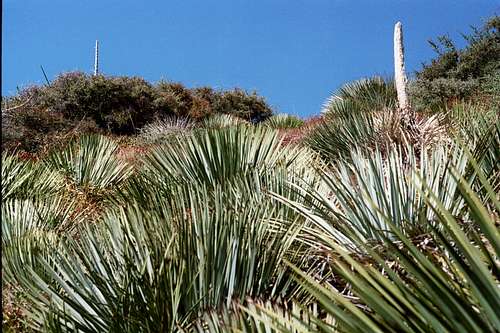
From the Red Box Ranger Station trailhead (4,600 ft.), cross the Angeles Crest Highway and go northeast along the highway for about 100 feet. The Barley Flats Fire Road comes up on your left. Take the fire road about ¾ of a mile to a trail junction also on the left.From the junction, follow the trail left and in about ¼ mile you will come to the starting point for Mt. Lawlor’s south ridge. There is currently a large wooden pole in the ground where the ascent begins. Leave the trail and begin your climb to the 5,957 foot summit.
 Looking up Mt. Lawlor's south ridge from point where ascent begins
The ridge is very rutted with a lot of loose dirt. Besides the regular chapparal, the ridge is choked with razor-sharp yucca plants so exercise great caution.
 Looking up Lawlor's south ridge route
Presently, there are six sections of thick wire anchored into the ground along the route which can be used as aid to hang onto as you go up or down. The wire sections are of varying lengths with the longest being about 30 feet. They seem to be strategically placed where the terrain is steepest or to safeguard against falling into a yucca plant.
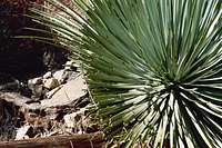 Wire "aid" poking through yucca on south ridge
Be particularly careful on the descent. You will be doing some sliding on your feet and, in few places, losing control of your slide would mean kissing a yucca plant head on.
 View towards south ridge route leaving summit of Mt. Lawlor
 Nearing the bottom of the south ridge. Trail junction is seen top right.
 Looking down the descent route on south ridge
Essential Gear
None. However, because of the loose dirt and rock along the ridge, you may want to wear gaiters or at least have on high top boots. And because of the brush, you should consider wearing long pants.There are no water sources along the way so take what you need.