
-
 2811 Hits
-
 72.84% Score
-
 3 Votes
|
|
Route |
|---|---|
|
|
41.91722°N / 111.6559°W |
|
|
Scrambling |
|
|
Summer |
|
|
Class 3 |
|
|
Overview
The standard route for Mount Magog is the Class 2 SW Ridge, and it goes at about 8 miles RT. Instead, one can opt for the south ridge, which is a little more direct and a little more challenging. In addition, it shows almost no evidence of human usage. While Mount Magog does not seem to attract a whole lot of climbers in the first place, the route via the south ridge offers a virtual guarantee of solitude. There is some Class 3 scrambling and a little bit of easy bushwhacking on this route.
Bonus: a couple of small, exposed subpeaks along the way that are more difficult to climb than Magog itself is.
Getting There
From Logan or Bear Lake, take U.S. 89 to Logan Canyon and then take the well-marked turnoff to Tony Grove Lake. Follow this steep but paved road to the trailhead at road's end.
Route Description
Because I did this route with my 8-year-old son and 6-year-old daughter, my pace was way off, so distances are more approximate than I normally would give. RT distance is around 7 miles, and elevation gain is about 1800'.
Just a few minutes from the trailhead, you reach a junction. Go left on the trail to Naomi Peak.
No more than 2 miles from the trailhead (my son did the return portion of the trail hike in less than 40 minutes), leave the trail shortly before it begins to climb to a saddle; you're at about 8800' here. Hike up steep slopes to gain the crest of a rise about 320 vertical feet above the trail. Now work to your right to go through or around a depression and gain the crest of the south ridge.
From here, the going is pretty obvious, and game trails make the going pretty easy as well. The two subpeaks are a bit less than halfway between the trail and the summit and are at approximately 9250'. Both are optional, and both are Class 3 with some significant exposure. Both are also well worth the small amounts of extra time and effort because the small summits have great views and an airy feel. The second (northerly) summit is a little harder and a little more exposed than the first one.
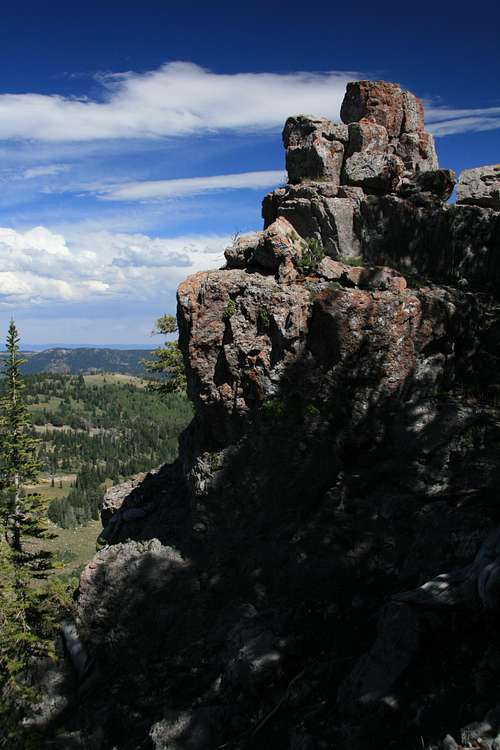
Continue along the ridge until you reach Class 5 cliffs near the summit. Hike along the south side here until you find a loose gully with a worn climber's/game trail through it up to the summit area. Then it's a quick walk and hop to your right to reach the actual summit block.

I call this a Class 3 route because of the subpeaks, which most people will probably want to climb. However, it would be possible to skip the subpeaks and keep the route at Class 2/2+.
To return, retrace your route, go via the SW Ridge, or descend the gully and then contour to the bump SE of Point 9614, from which you can descend to regain the trail. If you use the third option, keep a lookout for at least one cool sinkhole. The one I saw in August 2013 was filled with yellow wildflowers, a very striking effect.

The route line is broken in order to show the location of the subpeaks.
Essential Gear
You only need good hiking shoes or boots and standard day-hiking gear for this route.