
|
|
Route |
|---|---|
|
|
37.03680°N / 118.43456°W |
|
|
Scrambling |
|
|
One to two days |
|
|
Class 2 |
|
|
Approach
If you’re lucky enough to have made it to the Red Lake trailhead with your vehicle in one piece, be thankful! The actual trail begins about 100 yards to the north of where the trailhead sign is located. Park near the sign and walk to where the trail begins as there is no parking there.The lower portion of the trail is a loose, sandy slog that slowly transforms into more hard packed dirt and rock. After the sandy sections, the trail passes through some overgrown jungle areas where it may be difficult to follow the trail. Look for ribbons tied to the trees in these areas. If it seems too overgrown even for this trail, or starts to go downhill, you are probably off route. There is one stream crossing here which is the only water until the small lake before Red Lake is reached.
Once past this small lake, the trail begins to disappear. However, just follow relatively close to the stream feeding the lake and you will soon arrive at Red Lake.
Route Description
Above Red Lake, the route is a mix of large talus boulders and looser sand and dirt. The boulders are generally solidly locked together, however some will move unexpectedly so use caution. Snow can also linger depending on the year, but is usually avoidable during the summer.From Red Lake, follow to the right and above the stream feeding the lake and aim for a circle of greenery. From here, use trails can be found in the dirt sections but may be so loose that you will find travelling on the boulders easier. Continue up through the relatively low-angle boulders until you can see the headwall that leads to the ridge.
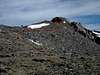
From here, you do not want to aim for the low spot on the ridge as there is a steep dropoff on the other side that will not allow you to get to the Split/Prater saddle. There is a couloir that accesses the ridge and lower portion of the north slope of Split Mountain that is to the left of the low point on the ridge. See the picture below for which couloir to use. Earlier in the season, this couloir can make for a nice snow climb. Otherwise, climb the rock just to the right of the couloir which has use trails leading through it. Use extreme caution here as the rocks are very loose and can easily go careening down the slope. A helmet may be useful here especially if there are other parties on the route. This portion of the route is rated as Class 3 by Secor, but I would rate it as steep and loose Class 2.
From the top of the couloir, you will have a great view of Mt. Prater’s south slope to your right. The summit is just poking above the far left of the plateau at the top of the south slope at this point. However, to get there, there is a disheartening Class 1 descent of approximately 400’ to the saddle between Split Mountain and Mt. Prater. Once at the saddle, climb the south slope of Mt. Prater. The right (east) side of the slope near Prater’s east face has solid, Class 2 boulders to scramble on which may be preferable to the looser materials found elsewhere on the slope. As you climb to the plateau, the slope’s angle will decrease and the ground will become sandier. At the top of the plateau, head left (northwest) to the now clearly visible summit. The travel along the flat ridge here is relatively easy. Approximately 5 minutes before you reach the summit, there is an exposed bridge that needs to be crossed. The rocks on top of the bridge are 2-3 feet wide, very flat, and very stable. However, there are steep drop-offs on both sides. It is very easy to cross this section and does not need to be given a second thought.
 |
 |
 |
 |