
|
|
Route |
|---|---|
|
|
39.09340°N / 106.5123°W |
|
|
Steep Hike, Snow in Spring Winter |
|
|
Half a day |
|
|
Class 2 |
|
|
South Slopes/Ridge Overview
This route is the shortest and steepest to the summit of Lackawanna. The climbing starts at the hwy and doesn't let up until you reach the summit.
Although not technical in anyway, this route is very demanding and is even more so with snow or rain. The TH is accesible in winter, however the surrounding area is a haven for large avalanches.
 |  | 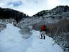 |
Approach
The starting point for this climb is located at 10,300 ft along CO 82, east of Independence Pass. When approaching from the east, follow CO 82 from it's junction with US 24 towards La Plata Peaks TH (Lake Creek TH) near mile marker 70.
Continue past La Plata's TH for about a mile until you see a very large avalanche path on the right (north) side of the road that comes all the way to the hwy, this is your starting point. No signs mark this TH.
There are several pullouts on the south side of the hwy that are suitable for parking. From here you can see most of the route which follows treeline along the right side of the avy path as it climbs steeply to treeline.
 |  |  |
Route Description
From the hwy, your route follows the rightside treeline towards a steep slope near treeline. In summer the avy path may provide the fastest way through the alders and aspens. In winter, it will be safer to pick the path of least resistance near the larger trees on the right.
When you near 11,000 ft you will begin to climb steeply towards treeline. This steep section can be icy and slick so be careful. Work you way through the rock bands enter some larger trees. There are lots of loose rocks in this area. As you continue to climb the terrain remains steep until you reach a more gentle angle near 12,500 ft.
At this point you will make your way along a narrow ridge before one last steep section. This steep section tops out near 13,700 ft. On a clear day you will have spectacular views of the surrounding peaks, which include some of CO highest. You are now only about 0.3 miles from the true summit which can be seen almost due north and is reached by an easy hike.
 |  |  |  |  |
Essential Gear
In summer, no special equipment is needed, although trekking poles will make the steep descent much easier on your knees.
In winter, this area can be very windy. This helps in clearing the upper ridges, however the lower slope may make snowshoes a must. A preview of the route from the hwy will help in making this choice.