-
 8626 Hits
-
 73.06% Score
-
 3 Votes
|
|
Route |
|---|---|
|
|
46.53722°N / 8.12611°E |
|
|
Mountaineering |
|
|
Most of a day |
|
|
AD |
|
|
III |
|
|
Overview
The South-West ridge is an harder alternative to the normal route.It is longer but more complete; it includes climbing on a long ridge (mostly II grade with a couple of pitches of III) and some mixed climbing in couloirs.
Unfortunately in the upper section the ridge is not well defined and several options are possible making the finding of the easiest crossings not always evident. The quality of the rock is average.
Getting There
The South-West ridge route deviate from the normal route at the Frühstücksplatz (3,616 m).Route Description
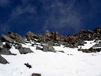
From the Frühstücksplatz follow the evident SW ridge, or if the snow is in condition climb the 40 degree snow field just on its left. At about 3,900 m take in a long twist couloir wich develops on the side of the ridge. The ridge itself can be on option to this couloir but with rock pitches of IV.
This couloir is normally in condition all year round but there is rockfall risk on very sunny days (the section is on shadow untill 10am).
At the end of the couloir (about 3,980 m) get on the left side again on the ridge, climb it for about 50 meters of height and arrive to a prominent gendarme. Climb the gendarme (or easier but more exposed solution traverse on its left) and arrive to a mixed terrain (poor rock) to traverse to get to another straight couloir that brings to a terrain of
easy rocks. From here easy scramble to the summit.
Several option for the descend back to the Finsteraarhornhutte. The easiest is of course the normal route.
The South-West ridge is not recommended for the descend because the quality of the rock and the nature of the route (couloir) reppresent the objective risk of ice and rock-falls.
A more direct, but exposed, alternative to the normal route for the descend is to take the large ice and rock couloir located on the East side of the South-West ridge. To get to the couloir descend (carefully de-escalading) on the left side of the ascend route and get to a vertical wall to abseil. From this point several abseils (or descend in the couloir if the ice is in condition) untill the base of the glacier sbout 70 meters lower than the Frühstücksplatz and from there gain the normal route back to the hut. An efficient party with about 2x60 meters of rope can get from the summit back to the hut in less than three hours following this route, albeit at a cost of leaving in place some slings or perhaps one or two pitons.


