
-
 3367 Hits
-
 74.01% Score
-
 4 Votes
|
|
Route |
|---|---|
|
|
37.86464°N / 13.36000°E |
|
|
Scrambling |
|
|
Spring, Summer, Fall |
|
|
Half a day |
|
|
Class 4 |
|
|
Scramble |
|
|
Overview
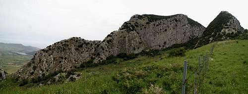 Rocca Ramusa south face Rocca Ramusa south face |
As mentioned on the main page, Rocca Ramusa has a weak spot on its south--western side, a ledge, which leads to the steeply sloped summit plateau. To reach this ledge you have to circle around the mountain either from the north or south since the trailhead at Ficuzza is located on the directly opposite site of the mountain. Apart from exposure near the summit the main obstacles to surmounta re the macchia bushes of all kinds. Especially the couloir through which the ledge can be reached is difficult to get through due to the undergrowth.
Both access trails - north and south of the mountain - are equally difficult to get through. While the southern route is the more beautiful one it scales steep slopes and finally all paths vanish. The northern route follows a dirt road at first (very difficult to find from Fonte Ramusa) and scales a small creek which is overgrown by a thicket of blackberries. There is no way but to walk on the blackberry brambles to reach the other side.
Getting There
The car access to Ficuzza has been described on the main page.Initial Access
 View from the trailhead to Rocca Busambra
From the exit of Ficuzza follow the wide but potholed road in direction of the Rocca Busambra summit. After a couple of hundred metres a side road turns off west with a sign to Fonte Ramusa. Follow this road - it will take you through the beautiful Bosco di Ficuzza to a farm house at Fonte Ramusa.
Southern Route
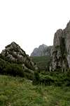
For the southern route to the trailhead for Rocca Ramusa follow the road a few paces more. It turns a sharp corner after which you have to enter the forest on the right side of the road. A long stretched clearing leads towards the gap between Rocca Ramusa and Rocca Busambra. Shortly before you reach the gap the clearing ends and again you have to cut through the dense forest. There is but one way through the gap, a steep canyon, through and up which runs a clearly visible path.
Once through the gap a beautiful rock face to the south-east of Rocca Ramusa can be seen. Either descend the steep gully between it and Ramusa or - like we did ourselves - pass it to the left (south and hike a half circle. At the end of the circle you will be close to the ascent trailhead.
|


Northern Route
From Fuente Ramusa head straight on for the north-east face of Rocca Ramusa. You have to scale two fences but will finally end up on a dirt road, which cicles the mountain to its north. After two saddles the road descends to an abandoned farm building. It turns around the building but then vanishes. In order to get to the trailhead you have to climb through a narrow creek which is overgrown by blackberries. follow the creek upwards until you find the overgrown ascent couloir (right after the first Ramusa rampart).
|


Route Description
- Start altitude: 828m (Fonte Ramusa)
- Summit altitude: 1276m
- Prevailing exposure: S
- Type: 40min on exposed and overgrown terrain
- Protection: unprotected
 The Route
From the trailhead near the abandoned farm climb down into a hollow where the ascent couloir starts. It is filled with dense bushes and thus is the crux of the climb. You have to get down on all fours to get through it and a backpack is a serious impediment. Better hide your backpack close to the trailhead. After a while the couloir opens to form a wide ledge. On the northern side of the ledge still bushes grow so that you are pushed to the edge. Luckily the ledge soon gets wider and reaches a fore summit. A short descent into a saddle is followed by a ridge route, which again is impeded by macchia bushes. The next fore summit can be passed on the southern side and then the summit block is reached. Either climb it directly or (as we saw afterwards) pass it to the southern side and come back from the west.