
|
|
Route |
|---|---|
|
|
45.12590°N / 117.3561°W |
|
|
Hiking, Scrambling |
|
|
Summer, Fall |
|
|
One to two days |
|
|
Class 3 |
|
|
moderate to strenuous |
|
|
Approach
 The gullies are on the upper right-center slope of the mountain in this view
 Approach below Needle
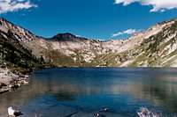 Eagle Lake
To reach the Eagle Creek trailhead from Baker City and Interstate 84, get on the interstate in downtown Baker City and go north for five miles to Exit 298. Exit and turn right on Chandler Lane/OR Highway 203 (also called the Medical Springs Highway). Continue for 18 miles to the small town of Medical Springs. There are only a few buildings here. Turn right on the Big Creek road that runs southeast away from town. After approximately three miles the road enters National Forest lands and is numbered Road 67. Stay on this road for approximately 15 miles until it meets Road 77 (Eagle Road) after crossing the West Eagle Creek. Turn left on road 77 and go almost a mile. Road 77 turns away to the left, but keep straight on road 7755. Continue approximately five miles to the Main Eagle trailhead. This drive requires approximately an hour and a half from Baker City.
From the Main Eagle trailhead at Boulder Park take Trail 1922 approximately six miles to the junction of Trail 1931. Trail 1922 turns west to Cached Lake, while 1931 turns east for another mile to Eagle Lake. This junction is very easy to miss and if one finds they have been traveling west for more than a few minutes, Trail 1931 has probably been missed. There is an old wood post with a fragment of a sign marking the junction, but in the brush it is very easy to miss it and the narrow track of 1931. From the junction take the 1931 1.1 miles east to Eagle Lake.
 Looking down Eagle Creek Canyon from the summit of Needle Point
Route Description
 Looking up from Eagle Lake
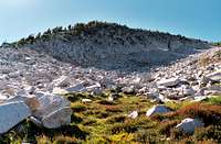 The cliffs at 8,700
 Entering the gullies
 In the gullies
 Top of the gullies
 Last little bit
There are a handful of routes up the east side of Needle Point, but this one avoids some difficult rocks on the main divide and minimized the difficult gullies on the southeast aspect.
From Eagle Lake make a steep hike from just east of the west end of the lake up to the broad cliff on the east block of the upper mountain (~8,700 feet). On the south or left edge of this cliff a small run up loose soil and rock gets one around the feature and passes side slope over some irregular outcrops through a stunted, open forest of whitebark pine and subalpine fir. Eventually the wide network of ravines that run directly to the upper summit wall is reached. It doesn’t really matter how these are ascended, just look ahead to be sure you’re in the one that goes directly to the summit rocks when getting high on the slope. Depending on which way one goes, this will mean crossing two or three ravines. The substrate in the ravines is loose decomposing granodiorite that offers nasty footing. Between the ravines there will be some broken outcrops that will allow some better footing but some of these rocks can be steep and/or loose so proceed cautiously. Once at the top of the ravine below the near vertical, firm upper summit rocks, scramble the right or the left a short distance to the top. Though this is very steep, there are many good steps and choices. Its probably all class 3 scrambling, but one can easily find themselves on more difficult rock if they are not paying attention. Again, be wary in the ravines because the ground is very weathered and rocks of all sizes are loose. This is a potentially dangerous place.
The entire trip would require one to be on their feet for approximately 16 miles with a total ascent of just over 5,000 feet. Its possible for a strong hiker to do this in a long day trip, but it’s best to stay a night at Eagle Lake, Cached Lake or in the valley below.
Essential Gear
Good hiking boots are all that is required. An ice axe and crampons are recommended for a spring or early summer attempt when snow will be present. The weather can be very unpredictable so bring something warm even if it seems like a warm day. There is no water above Eagle Lake so plan accordingly. The small summit of Needle Point