
|
|
Route |
|---|---|
|
|
40.18190°N / 105.6458°W |
|
|
Mountaineering, Scrambling |
|
|
A long day |
|
|
Class 3 |
|
|
Approach
From the Finch Lake trailhead follow the signs for Finch Lake and Pear Lake. The trail initially climbs eastward for about a mile and then switches back west. After 1.8 miles it intersects trails coming from the Allenspark area; to go to Pear Lake keep right (north). After another mile the trail comes to another crossroad where you will take the middle path. Both these intersection have clear signs. Finch Lake is reached after about 5 miles and Pear Lake appears to the right of the trail after another two miles. | 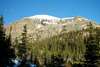 |
Route Description
This route is a variant of the southeast slopes route described by Roach. It climbs an evident gully to reach Copeland Mountain's east ridge instead of contouring the base of the peak.From the Finch Lake trailhead reach Pear Lake in about 7 miles. The good news at that point is that you have covered over three fourths of the distance. The bad news is that you still have to gain about two thirds of the elevation.
Don't be lured by the bridge that crosses the outlet stream of Pear Lake. The trail on the other bank leads to a campsite. Instead, follow the north shore of Pear Lake to a very large boulder. Strike north from there until you reach a plateau with two shallow unnamed lakes at 10,800 feet. From there, the gully will be in front of you. In summer conditions, the gully is a steep but easy Class 3 scramble on mostly stable terrain. About half-way up, the gully forks for a short while. I climbed the left branch. The right branch has a large chockstone, which, however, should be passable. As usual in these cases, keep to the sides of the gully to avoid loose rock.
Once on the ridge, at approximately 11,400 feet, turn left and climb the remaining 1,800 feet on talus. The dome shape of Copeland Mountain means that the true summit only becomes visible at the very end. The total distance is about 9 miles and the total elevation gain is about 4,700 feet.
Descent: Retrace your steps if you want to descent the same route. Consider, however, descending to Ouzel Lake. It's shorter, and adds variety to your hike. On the negative side, it involves bushwhacking.
 |  |  |  |