
|
|
Route |
|---|---|
|
|
40.44420°N / 105.6887°W |
|
|
Hike/ Steep Snow |
|
|
Most of a day |
|
|
Class 2+ |
|
|
Intro
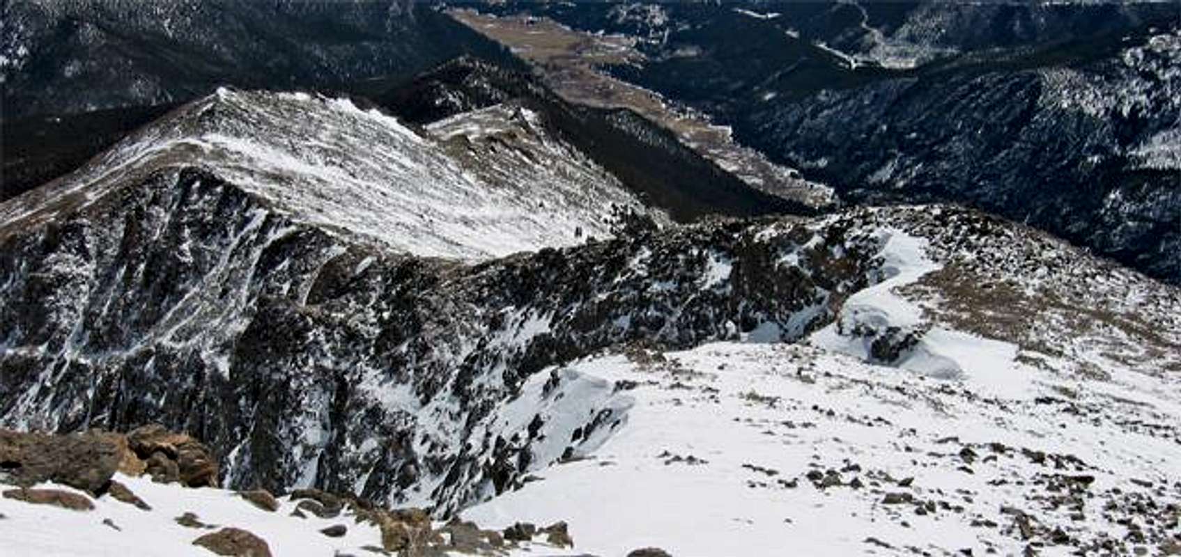
Looking down on the SE Ridge from pt. 12,537
This is a great route to the summit of a wonderful mountain that is otherwise inaccessible in the winter months. I called this a class 2+ route simply because there were spots where using my hands to pull over obstacles was very helpful. Sure, with more patient routefinding, this would be simply a class 2 walk up.
The views of Ypsilon Mountain from the approach and from the ridge proper are outstanding!
This is a great winter route for those Rocky enthusiasts!
Distance Round Trip: 11.63 miles
Elevation Gain: 4,529 feet
The best way to summit Mt. Chiquita while Old Fall River Rd is closed is to begin at the Lawn Lake trail head. To get to this trailhead, enter the National Park through the Fall River Entrance, Hwy 34. About 2 miles into the park, take a right where the signs point you to "Old Fall River Rd." and "End o' Valley." Once on this road, you will take your first right, where signs clearly point you to the "Lawn Lake Trailhead."
You will follow the Lawn Lake trail for 1.3 miles before coming to the trail junction with the Ypsilon Lake trail. Take a left and follow the Ypsilon Lake trail for approxamately 2.5 miles. Just before you get to Chipmunk Lake, begin looking to you left to find the best way through the dense forrest up to pt. 12,005. The slopes just to the NW of 12,005, while wind blown and relatively snow free when I was on them, look like they could be pretty dangerous and avy prone just after a large snowfall. Use caution. These are also something to respect on the descent. An untimely stumble could turn into a speedy descent into sharp rocks. If you stay on the "ridge" to the northeast of pt 12,005, the terrain is not quite as steep and more boulder-strewn than anything.
Once you gain this ridge leading from point 12,005 to the summit, it is pretty self explanitory. Just up and over pt. 12,537 and it's a simple walk over a large gentle snowfield to the summit. Again, use judgement as some of these rises in the ridge are very steep and I am glad it had been windy up there for the past few days. With a fresh dump of snow, these would have a much different personality.
This ridge is similar to most in the Mummy's. Mainly gentle rises littered with medium/large boulders, with the occasional steep section thrown in there for good measure.
This is a route that I feel is best suited for winter/spring. In the summer, it is an easy hop, skip and a jump to the summit from Chapin Pass. And I think the snow cover makes this route a bit easier, especially around the slopes leading to the ridge west of pt 12,005. These look like they may be a bit marshy in the summer/fall.
If anyone has info on this route during the warmer months, please add any info you can!!
Winter/Spring: Winter essentials, snowshoes, etc.
Crampons came in handy as there had been warm days and cold nights so most of the steeper slopes were very hard packed and very icy. These were not mandatory, but I felt they were an asset. Ice Ax? I brought one, but never even thought about using it, so that is up to you.
I think snowshoes would be best for the approach. I couldn't imagine using ski's for some of the terrain between the trail and pt. 12,005.
Summer/Fall: Summer hiking essentials.
Make sure you have planty of water, there really isn't any place to refill. You would have to go to Chipmunk Lake before heading up to the ridgeline.
![]()
USGS Quad "Trail Ridge"
RED is the route I took.
YELLOW is an alternative in order to avoid possible avy dangers en route to pt 12,005.
The views of Ypsilon Mountain from the approach and from the ridge proper are outstanding!
This is a great winter route for those Rocky enthusiasts!
Distance Round Trip: 11.63 miles
Elevation Gain: 4,529 feet
Approach
The best way to summit Mt. Chiquita while Old Fall River Rd is closed is to begin at the Lawn Lake trail head. To get to this trailhead, enter the National Park through the Fall River Entrance, Hwy 34. About 2 miles into the park, take a right where the signs point you to "Old Fall River Rd." and "End o' Valley." Once on this road, you will take your first right, where signs clearly point you to the "Lawn Lake Trailhead."
 |  |  |
Route Description
You will follow the Lawn Lake trail for 1.3 miles before coming to the trail junction with the Ypsilon Lake trail. Take a left and follow the Ypsilon Lake trail for approxamately 2.5 miles. Just before you get to Chipmunk Lake, begin looking to you left to find the best way through the dense forrest up to pt. 12,005. The slopes just to the NW of 12,005, while wind blown and relatively snow free when I was on them, look like they could be pretty dangerous and avy prone just after a large snowfall. Use caution. These are also something to respect on the descent. An untimely stumble could turn into a speedy descent into sharp rocks. If you stay on the "ridge" to the northeast of pt 12,005, the terrain is not quite as steep and more boulder-strewn than anything.
Once you gain this ridge leading from point 12,005 to the summit, it is pretty self explanitory. Just up and over pt. 12,537 and it's a simple walk over a large gentle snowfield to the summit. Again, use judgement as some of these rises in the ridge are very steep and I am glad it had been windy up there for the past few days. With a fresh dump of snow, these would have a much different personality.
This ridge is similar to most in the Mummy's. Mainly gentle rises littered with medium/large boulders, with the occasional steep section thrown in there for good measure.
This is a route that I feel is best suited for winter/spring. In the summer, it is an easy hop, skip and a jump to the summit from Chapin Pass. And I think the snow cover makes this route a bit easier, especially around the slopes leading to the ridge west of pt 12,005. These look like they may be a bit marshy in the summer/fall.
If anyone has info on this route during the warmer months, please add any info you can!!
Essential Gear
Winter/Spring: Winter essentials, snowshoes, etc.
Crampons came in handy as there had been warm days and cold nights so most of the steeper slopes were very hard packed and very icy. These were not mandatory, but I felt they were an asset. Ice Ax? I brought one, but never even thought about using it, so that is up to you.
I think snowshoes would be best for the approach. I couldn't imagine using ski's for some of the terrain between the trail and pt. 12,005.
Summer/Fall: Summer hiking essentials.
Make sure you have planty of water, there really isn't any place to refill. You would have to go to Chipmunk Lake before heading up to the ridgeline.
Map
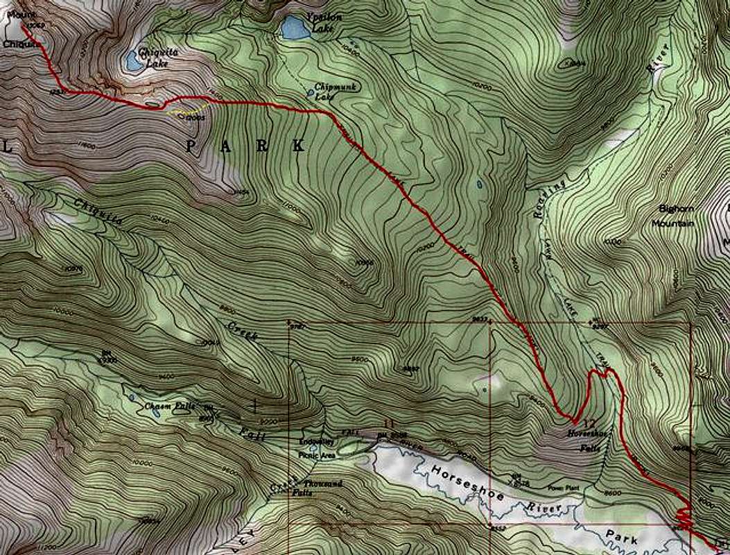
USGS Quad "Trail Ridge"
RED is the route I took.
YELLOW is an alternative in order to avoid possible avy dangers en route to pt 12,005.