
|
|
Route |
|---|---|
|
|
40.78350°N / 107.3694°W |
|
|
Hike |
|
|
Half a day |
|
|
Class 1+ |
|
|
Approach
From the junction of Highway 40 and 13 in Craig, turn north on Highway 13. Drive north for about 13 miles to north of mile marker 102 until you see a sign posted for County Road 27. The road is posted for “Forest Service Access” and “Black Mountain”. Drive County Road 27 through private lands for 10 miles which is where you reach the Route National Forest boundary. The road becomes FR 110. Stay on the main road for another 4.4 miles or so and park at an obvious saddle. This is about 14.4 miles from the highway. The road is gravel, but any car can make it, at least between July and September or October.
Route Description
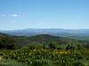
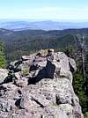
This trail is not shown on the topo maps, but is marked on the map Routt National Forest. The trail begins on the north side of FR 110 at the parking lot. Follow the trail north and up the mountain. At first the trail is a little faded, but it becomes better defined after just a short distance. As with all the trails around Black Mountain, plan on climbing over some fallen timber. The trail stays to the west of the ridgeline, and there are not too many views at first because of thick timber. The trail is rather gentle until climbing to the ridge-top. Along the way, you will notice an (illegal?) ATV track joining the trail from the south, and probably from Forest Road 138(?). Make sure not to mistakenly follow the ATV track on the return trip. The trail climbs to the ridge and begins climbing to the summit plateau while making several switchbacks. Once at the rim, head east to a fantastic viewpoint (Welba Benchmark 10,801) on the topo map. This point has the best views around, but is not the true summit. To reach the true summit, either follow the faded trail north and then west, and head for the summit, or follow the rim of the summit plateau west and slightly north to the summit. Enjoy the fantastic views. To the south is the Yampa River Valley and the Flat Tops; to the east are the other peaks in the Elkheads and the Park Range and Mount Zirkel Wilderness. Wyoming and the Medicine Bows are to the north and northeast, and Utah can be seen way out to the west. Because this peak more or less stands alone, the long distance views are outstanding.
The route is six miles round trip with only 900 feet elevation gain.


 |
Essential Gear
A good pair of boots is needed. A map and compass (or GPS) is recommended, although the trail itself is not marked at all on the topo map.