
-
 3904 Hits
-
 72.83% Score
-
 3 Votes
|
|
Route |
|---|---|
|
|
51.12500°N / 116.0083°W |
|
|
Mountaineering |
|
|
Summer |
|
|
A long day |
|
|
Difficult Scramble |
|
|
Approach
This is a 5200’+/- ascent day. Cross the road and gain the Hawk Creek Trail. Hike the trail almost to the Ball Pass at 7200’, just under 10 km. You will be traveling through mostly burnt out forest (2003 massive fire). You will eventually pass a beautiful waterfall in Hawks Creek on your right. Soon after this point you start to make your way more aggressively up the trail via several switchbacks. As the grade eases off, look for a well marked cairn on your left and the east slopes of Isabelle Peak. |  | 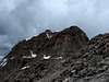 |
Route Description
Start ascending an avalanche gully west of the trail and aim for a water worn break in the gray rock band above tree line and below the eastern talus slopes of Isabelle. Some quick hands on scrambling will get you through this portion and put you on decent ground. Follow the drainage up into a small cirque below Isabelle’s eastern-southeastern ridge. Snow could easily still obstruct any straight up approach. We followed some solid ledges up to the left, gaining a small plateau and then continued to climb to the right until we topped out on the ridge itself.Now you can see your objective, Isabelle’s summit block, to the northwest. Continue along the firm ridge as it curves westward, but be prepared to traverse left to avoid unnecessary gain, aiming for a steep east facing rock face on the ridge. Do not gain the ridge again, instead continue traversing below this steep obstacle until the summit’s access comes into full view. Continue to traverse below the ridge aiming for the drainage coming off of the remaining snow on the summit. Stop short of this drainage and find the narrower firm gully to the right of it. This is the crux of the climb, approximately 200-300’, basically firm rock holds requiring a climbing move or two and of course loose rock available to knock down on your partner. It eases off fairly quickly into ledges and now you regain the ridge just below the summit block. This is when Mount Ball and her hanging ice come into full view and make for the best photo op of the day.
Follow the ridge to the base of Isabelle’s summit block and ascend via hands on climbing wherever you prefer. There was quite a bit of snow left on the ridge at this point in July. There is a summit register and a sizable summit plateau in which to soak up the views. The weather was such I did not get the full show, however, Mount Assiniboine and Mount Sir Douglas are in clear view to the south, the Goodsirs are clear to the north and the close up views of Mount Ball’s hanging ice are spectacular. You can try to make out Shadow Lake Lodge below, but will probably just notice a green spot representing the meadow where it is located.
You return the exact same route and might find some snow to assist in descent, but no fast scree. There does appear to be another option or two for descent further west, but I did not explore them. I recommend you make this an overnighter and combine it with some sort of traverse through Ball Pass.