
|
|
Route |
|---|---|
|
|
40.35440°N / 105.7206°W |
|
|
Scrambling |
|
|
A long day |
|
|
Class 2/Bushwhack |
|
|
Approach
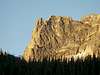
From the Fern Lake Trailhead hike to Spruce Lake. Initially, you follow the trail for Fern Lake, but just before you get there, you encounter a well marked fork. Keep right and reach Spruce Lake in about 4.5 miles. Only the last stretch of the trail is a little rough. Don't worry: this will soon change. Fern Lake is so close to the fork for Spruce Lake that a detour to visit it will only cost you a few minutes. From Fern Lake you have excellent views on Notchtop, Little Matterhorn, and the Gable.The southern area of Spruce Lake is subject to seasonal closures to protect wildlife. The closures, usually from May 15th to August 31st, do not interfere with this route, but be mindful of them in case you decide to explore the area around the lake.
 |
Route Description
Be warned: This is a serious bushwhack. The slopes are steep and the forest is very thick; deadfall abounds. If you get lost or hurt, it's unlikely that they will find you. Once you are above treeline, the difficulties can be kept at Class 2, but you'll have to climb a very long ridge. From where you cross Spruce Creek to the summit you gain over 3000 feet of elevation. Study the itinerary, bring map and compass or GPS, and be extra careful.From the campsite half way along the north shore of Spruce Lake, strike north and start bushwhacking. You first ascend to the crest of the ridge coming down from Castle Rock, and then descend into Spruce Canyon. Your objective is to climb from the creek to the ridge that ascends in the northwesterly direction towards "Stapps," an officially unnamed secondary summit of Stones Peak. Long after you've stopped bothering about the number of scratches on your limbs and the number of pine needles in your underwear, you reach treeline. The terrain becomes progressively more rocky as the ridge crest becomes better defined.
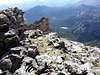
Climb close to the crest, avoiding difficulties mostly on the left (southwest). If you pick your route carefully, this ridge is mostly Class 2. There is an infinite number of false summits along the ridge; or, at least, so it seems. You know you have reached the summit of Stapps when you have full view of the broad ridge connecting it to Stones Peak. Hence, feel free to bypass all the false summits.
There used to be a summit register on Stapps. At least, the broken glass jar and the shattered pen in the summit cairn suggest so. The marmots must have gotten the contents of the jar some time ago. From Stapps, cross southwest along the broad ridge and reach the summit of Stones Peak in about a half mile.
 |  |  |