
|
|
Route |
|---|---|
|
|
36.43344°N / 118.56445°W |
|
|
Download GPX » View Route on Map |
|
|
Class 3 |
|
|
Getting There
From Visalia drive east on State Route 198. 4 miles passed three rivers You'll come to the signed Mineral King Road turn off. Proceed up the sometimes tedious road for 23 miles to the Sawtooth trailhead. Several sections of the Mineral King Road are gravel but are improved and easily passable to any vehicle.Approach
 Route Map
The beginning of the Sawtooth Pass trail slowly switchbacks up the valley wall. After a mile you'll arrive at Groundhog Meadow. From here there are 2 options, either continue up the main trail as it switchbacks slowly through the forest or head into the meadows and follow an unmaintained trail which heads directly up the drainage toward the Lower Monarch Lake. Though hard to follow at places I personally would recommend the unmaintained route for its superior views and more direct line of ascent. See the map at left for specifics.
Route Description
Head around Lower Monarch Lake on either the east or west shore to the granite blocks above Lower Monarch. Head up these blocks to the dam on Upper Monarch Lake. Good Views open up on the way.

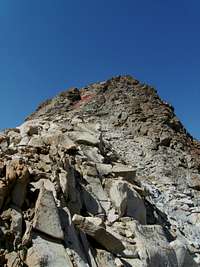 Final Gully Leading to summit
 Ridge Above Upper Monarch Lake
From Upper Monarch Lake attain the saddle between Mineral Peak and the unnamed peak at the head of the cirque. Numerous options here; I chose to head directly up toward the head of the cirque, then loop around to a gully right bellow the peak, but this is not mandatory.
Once at the saddle begin scrambling along the ridge, after a few hundred yards you'll enter a gully, and the climbing intensifies. The final 200 feet or so are an enjoyable class 3 scramble on good rock.
Views from the summit will not disappoint. The small summit seems to hover above the Monarch lakes.

Descent
 Cliffs above Crystal Lake
 Cliffs from the other side
Once back at the saddle the quickest way down is to take the scree slope down to Upper Crystal Lake, then follow the Crystal Lake trail back to the trail head. This option is also a possibility for ascent but the route up from Upper Monarch Lake is scree free and much more efficient. While descending to Lower Crystal Lake one should not reach the lake surface. The reason being, the cliffs plunge straight down into the lake and one will have to backtrack and climb around them. Instead head southwest from Upper Crystal lake to a dome shaped knoll of orange rock, then head west downhill to the Crystal Lake trail. From here simply hike back to your car. Statistics are around 11 miles round trip with 3900 feet of elevation gain.