
|
|
Route |
|---|---|
|
|
39.85220°N / 105.6894°W |
|
|
Hiking |
|
|
Half a day |
|
|
Getting there
Take I-70 to exit 238. Turn north onto Fall River Road and go 6.6 miles to a sharp right hand hair pin turn. Instead of making that turn, make a quick left, cross the creek and then continue west on the dirt road. About a half mile after turning onto the dirt road you will recross Fall River, head north for just a bit, come to what appears to be a place to camp, and then turn left to head back west. From when you turn off the paved road to the trailhead is 1.6 miles. This dirt road for the most part passenger cars should be able to navigate with little problem, but watching where they drive in a couple of sections.The trailhead is at 39,48.673N, 105,40.038W and at 10,151 feet
 Sign at trailhead
Sign states the distance to James Peak is 4 1/2 miles, whereas I measured it with my GPS to be 5 miles.
Route Description
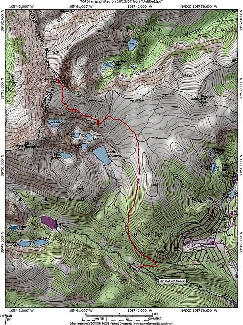
There is a well defined trail all the way to the summit.At first the trail heads east, then switches back to the west for a short distance. The trail then splits, with one trail heading west (left) and the other heading northeast (right). The northeast fork goes a short distance to the road to Loch Lomond, if you head west (left) on the road you will come back to where the other branch of the trail crosses the road. Back to the trail junction, if you follow the left branch you will hike below the Loch Lomond road, and at times see metal pipes that probably use to carry water from higher up, but have long since ceased to serve any function. After awhile the trail will cross the road and start to head up through a mixed aspen and evergreen forest until you get to about 11,000 feet when the trees start to get stunted.

 Looking south down old wagon road
Continue to follow the trail is it starts to head west. Just before you come to a small boulder field at a little over 12,000 feet there is a faint trail that heads south to overlook Lakes Stewart, Ohman and Reynolds. Higher up on the trail you have another opportunity to look down upon these lakes as well.
When the trail crosses the small boulder field, the trail gets a little faint, but is still easily followed. After you pass of the boulders, the trail is well defined again all the way to the summit.
Map
Red Tape
Part of this trail is in the James Peak Wilderness Area. While there are no fees for day use, there are certain regulations that need to be followed.# Pets must be on a handheld leash at all times.
# Camping is prohibited within 100 feet of lakes, streams and trails.
# Campfires are prohibited.
# Group size is limited to a maximum of 12 people or people and packstock combined.
# Motorized or mechanized equipment, including mountain bikes, wagons, carts and chainsaws, are not permitted (wheelchairs are allowed).
# Hobbling, tethering or picketing of packstock is prohibited within 100 feet of lakes, streams or trails.
# Only pelletized or steam-rolled feed grains, or certified weed-free hay, straw, or mulch are allowed.
Permits are not required for camping in the James Peak Wilderness Area, as they are in the nearby Indian Peaks Wilderness Area.