
-
 2413 Hits
-
 75.81% Score
-
 6 Votes
|
|
Route |
|---|---|
|
|
40.42750°N / 105.8373°W |
|
|
Hiking |
|
|
Spring, Winter |
|
|
Half a day |
|
|
Overview
 Ascending the ridge
This is a pleasant outing from the winter closure of Trail Ridge Road on the west side of Rocky Mountain National Park. The navigation is relatively direct, though between the road and timberline you will be in thick woods, so keep your sense of location sharp. Upon breaking out of the dense timber, the views to the north and west, in particular, will have you struggling to keep your head down watching your step.
Roundtrip Distance: 6 mi
Elevation Gain: 2,200 feet (net)
YDS Rating: Class 2
Getting There
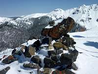 Shipler Mountain Summit Cairn
 Final push to Shipler summit
The Timberlake Trailhead is the winter trailhead for this route. The trailhead is on the east side of Hwy 34 north of Grand Lake.
• From I-70, exit US 40 (between Georgetown and Idaho Springs) and head north/west toward Granby.
• In Granby, follow US 34 north toward Grand Lake.
• Timber Lake trailhead is about 10 miles north from the Kawuneeche visitor center on the east side of US 34.
Route Description

 Nearing timberline on Shipler Mountain
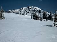 Specimen Mountain comes into view
• Depart the parking area and follow US 34 northward toward the winter closure gate.
• Follow the road for about ½ mile, then depart the road heading northeast through dense timber.
• After a bit less than half a mile of steep, off-trail ascent, you will again cross the road and should arrive at/near the southern ridge of Shipler Mountain.
• Ascend the ridge, sticking on or near the top of the ridge, for about 1 mile north.
• The ridge will begin gently curving to the northeast for about 1 mile to tree line.
• Upon reaching timberline, the summit of Shipler Mountain may come into view to the northwest.
• The last half mile of the route is through sparse timber or krumholtz at or just above timberline, curving sickle-like to the summit of Shipler Mountain. From the false summit to the southeast, the true summit (and summit cairn) will be visible.
• Cross a high saddle between the two summits, striking northwest to the summit cairn.
• Enjoy the sensational views before retracing your steps.
Essential Gear
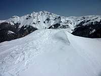 Specimen Mountain from the Shipler summit ridge
 Heading northwest on the ridge
• Flotation (snowshoes would be ideal given that much of the route travels steep, densely-timbered slopes).
• Trail Map (Trails Illustrated #200 – Rocky Mountain National Park – would meet basic navigation needs.)
• Compass or GPS
• Water and snacks
• Insulated, water-proof boots
• First aid kit
• Camera