
|
|
Route |
|---|---|
|
|
44.25660°N / 15.83600°E |
|
|
Hike |
|
|
Half a day |
|
|
Walk up |
|
|
About Route
Prezid (768m) – Crnopac (1404m): 2.30h
This trail is not as attractive, in terms of scenery and little details around it, as northern route but when comparing panoramas southern route can’t be matched by northern. Northern route spends most time in northern chaos of Crnopac with quite closed views while this route, except lower part, is completely open with amazing views.
This route is also easier as it goes straight up all the time while northern route has many ups and downs. Lower third is in idyllic beech forest which grows above heavily developed karts terrain, so it not usual forest but the one that changes constantly and has many small corners, boulders between trees. Upper two thirds of the route are on open southern slopes which are rocky with few lonely beeches and various bushes and junipers.
Route Description
Trail begins on Prezid pass. How to get there read on main page. Trail begins some 500 meters from the tunnel in Gracac (north) direction, on the spot where macadam road towards Celavac peak begins.
Marks immediately turn left, away from the road. In 5mins you reach little grassy plateau called Musinovac where are three ponds that are walled around and where used as watering place for animals.
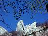
Marks turn left and enter the beech forest. Path ascends quite steeply all the time till you reach nice meadow, 50 minutes from Prezid. From meadow is very nice view on white cliffs of Crnopac that rise above beech forest. Straight above is Western summit of Crnopac.
From the meadow path turns right and suddenly you are on open southern slopes of Crnopac. View literally explodes on this spot. Bellow is Prezid road, quite bellow already. Further bellow canyon of Zrmanja river while far back sea and islands. Path turns sharply left and gradually and ascends over rocky terrain with some bushes. In some 10-15 minutes you reach collapsed house and few lonely beeches. Path continues to ascend and after some 40 minutes from meadow you are at small pass where view towards SE and Dalmatian mountains opens, including Dinara, highest in Croatia.
Behind the pass path descends little bit but soon turns left and continues to ascent steeply. In 15 minutes you are on top of small head and summit of Crnopac is in front of you, looks very steep and it is. On the left is western summit with its smooth white cliffs. From here you have to descend some 50 meters to the foot of the peak.
After 15-20mins of steep ascent over broken terrain and around few beech and maple trees path reaches the pass on the ridge. Here is important junction. From left our path is joined by Northern route which leads towards Tatek refuge via western summit (2.40h).
Above the pass there is steep but short climb till ridge levels and further panoramic walk to the summit, 10mins from the pass, 2.30h from Prezid.
 |