
|
|
Route |
|---|---|
|
|
39.00950°N / 106.4982°W |
|
|
steep hike/mod snow climb |
|
|
Most of a day |
|
|
Class 2+ |
|
|
Approach
In Spring/May-Round Trip 8 miles and 3,200-ft
The following is a good route for a late April/May ascent of Sayres BM. With consolidated snow, the basin below the southwest face of Sayres will travel fast. Without the snow, you’re looking at a few miles of talus hiking along with a 1000-ft slog up more talus to the summit. The southwest face sets up nice in May for a fast snow climb of moderate steepness to the summit of Sayres. There will be some nasty tree snow to deal with at the start of your day, however, with some perseverance and good route finding you will get above tree line. Bring snowshoes, an ice ax and crampons for this route.
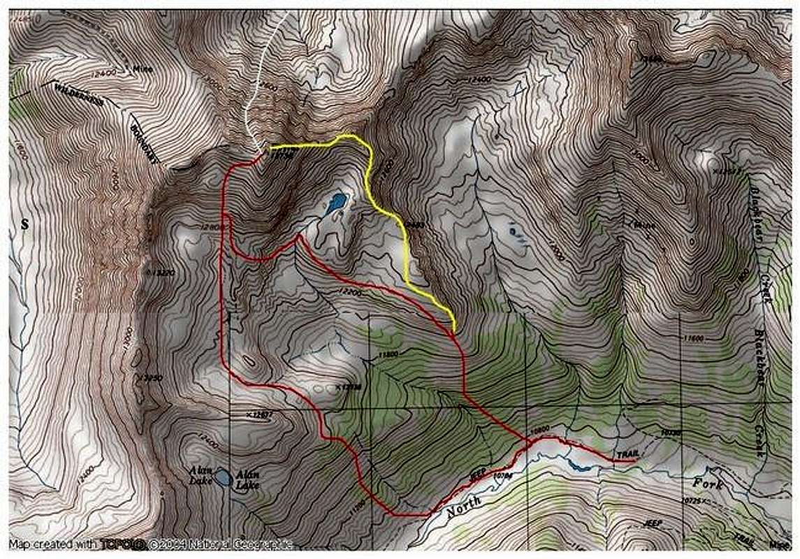
Starting at 10,780-ft, locate a steep tree-covered slope to the right, see TOPO. That slope will get you into the huge, wide open basin below Sayres southwest face. On the TOPO map, locate a larger stream that descends the slope. A little southwest locate another smaller stream that descends from that basin. The terrain in-between these two streams makes for easy, albeit steep hiking up into the basin. In the winter/spring these trees hold a lot of snow so be prepared for it.
Ascend the slope for about 800-vertical feet, to about 11,660. From here the slope relents a bit but you are still very much in the trees. At this point it is important to locate point 12,738 on the TOPO and begin to hike toward it. The temptation here in the trees is to continue hiking north, but you really need to go more northwest up steeper terrain. From below Point 12,738 you will pop out of the trees above tree line where the route finding will become more apparent.
Locate a “side” basin that takes off to the left or to the west. From here the southwest face of Sayres is visible and the route to get there becomes fairly obvious. Hike below points 13,250 and 13,220, which are to your left and continue to a small picturesque lake at 12,600-ft. This lake is not shown on the TOPO, but it is there and in May is frozen over. Looming above, the southwest face of Sayres is totally obvious. In May, the talus-covered slope is covered in consolidated snow, and reaches about 30 degress for a nice 1000-v-ft climb.
Route Description
Begin the moderate snow climb and climb a half mile and 1,000-ft to the crest of Sayres west ridge. With snow, has no technical difficulties other than its steepness. From here you can have a peek down the awesome North Face Couloir Route. Continue up the west ridge on stable talus to its lofty summit.
See submitted TOPO for an alternate descent route.
Essential Gear
May-snowshoes/Ice Ax/ and Crampons.
Miscellaneous Info
If you have information about this route that doesn't pertain to any of the other sections, please add it here.