

-
 12467 Hits
-
 89.77% Score
-
 30 Votes
|
|
Route |
|---|---|
|
|
48.67147°N / 113.72326°W |
|
|

|
|---|
Overview
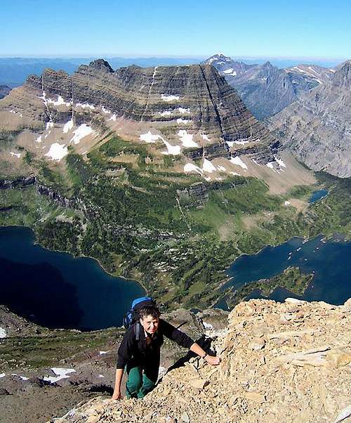 Scrambling on lower ridge
Distance: about 5 miles (one way)
Elevation gain: about 2,500 feet
Edwards describes the route as “very enjoyable, as it almost completely avoids the great scree slopes, and it provides a stimulating alpine challenge”. He also states that it is “probably the shortest and fastest route” up the peak.
The route on the lower part of the ridge is quite flexible with scrambling anywhere from class 2 to 4 depending on the exact line and how closely the ridge crest is followed. Once in the upper cliffs, the climbing becomes exposed class 3 to 4. The crux crack is described by Edwards as “class 4 or perhaps 5”. The GMS usually calls it 4+. The difficult part is short, but a fall here would be serious and potentially fatal.
For those not interested in climbing the lower part of the ridge, it is possible to traverse from the Southwestern Talus Slope Route to the upper cliffs. Conversely, it is possible to traverse from the upper cliffs to the easier Southwestern Talus Slope Route for those not interested in climbing the exposed upper part of the Southwest Ridge. See the variation described below.
Denis and Shirley Twohig made the first recorded ascent in 1980.
Approach
Use the recommended and NPS authorized approach to Reynolds Mountain. If you are not familiar with it, maps are available in the Logan Pass Visitor’s Center and one is posted a short distance up the trail. This trail gets you to Reynolds Mountain very efficiently and stays mostly on talus thus preserving the high mountain meadows.The trail leaves the main Hidden Lake Overlook trail at about one mile. It is obvious and frequently marked with small cairns. Follow the trail across the talus on the west side of the mountain. Take the upper trail where it splits at about 2/3 of the way across the slope. This upper trail will lead you directly to the couloir at the start of the Southwestern Talus Slope Route. This is the first couloir around the corner and should be well marked with cairns.
NPS PDF file with maps and descriptions of Logan Pass access routes
Complete Southwest Ridge
 Telelphoto of upper ridge - main features labeled
Climb the initial couloirs of the Southwestern Talus Slope Route. Once above the couloirs and on the trail, look up to your left for the bottom rocks of the Southwest Ridge. Leave the trail at a good spot to traverse to the bottommost outcrops on the ridge. As of August 2010, there was a very faint track beginning to form.
Finding the “keyhole” at the lowest outcrops will confirm that you are on the correct ridge.
From here, continue up the ridge on either the crest or just east of the crest, as you prefer to the upper cliffs where the climbing becomes more difficult and your options become more limited.
Climb the ridge crest up and climber’s right to the shallow steep couloir described by Edwards as being twenty to thirty feet high. This will lead to a nice ledge which is followed a short distance eastward to just below a very distinctive depression in the cliff with an outcrop of black rock.
 Near Shallow Couloir Near Shallow Couloir |
 At the Black Rock At the Black Rock |
 Ledge below crux Ledge below crux |
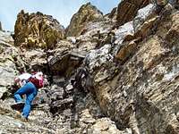
Climb up and past the black rock, first climber’s right then left to another ledge just below a short very steep cliff. You are now at the crux.
There are two “cracks” leading through this cliff. Edwards describes the crux as follows:
“The crack is almost a narrow chimney, and is overhung, tending to push you out and over the top of the cliff. This awkward pitch is only eight or ten feet, but requires delicate negotiation.”
Note that the cliff is higher than 8 to 10 feet – the 8 to 10 feet refers to the difficult part of the pitch.
Both cracks will get you to the top and are probably about equally difficult.
 Left Crack
Blake climbed the one on the left and describes it as follows:
Scramble to the right to a small platform and then to the left to a difficult chimney section that tends to push the climber out of the chimney. Carefully climb up to the top of this chimney after handing packs up using a rope.
Above this difficult chimney is another section that is a bit wider and feels more secure. It is possible to stem between the opposite slabs until solid holds can be found to climb to the right. Send packs up on a rope here as well.
From the top of the opposing slabs the rest of the route is easy class 3 to where the route joins the Southwestern Talus Slope Route and follows the summit ridge to the summit.
Although we climbed this pitch unroped, I would NOT recommend it.
Fred and Moni climbed the one on the right after some debate as to which one better fit the description in Edwards. This crack (we would call it a narrow chimney) led all the way to the top of the cliff in one section:
We opted to rope for this pitch which was nicely protected using a number 2 ½ and a number 3 Friend. There is a block at the top around which to put a long runner for a belay anchor.
The bottom section overhangs and as advertised tends to push you out. Above the initial overhanging section it is relatively easy chimney climbing. We both climbed wearing our packs and had no problems.
Above this cliff, it is an easy scramble to the summit ridge – or you can walk about 10 yards easterly to the top part of the Southwestern Talus Slope Route just below the summit ridge.
 Right Crack Right Crack |
 Leading right crack Leading right crack |
 In upper right crack In upper right crack |
Traverse Variation
 The Traverse Variation Begins from Southwestern Talus Slope Route
To reach the Traverse Variation follow the Reynolds Mountain climber’s trail to the top of the scree fields on the Southwestern Talus Slope Route. The alternate route to the Southwest Ridge leaves the Talus Slope Route and traverses to the left along a horizontal ledge to the north.
Do not climb up to the right along the Talus Slope Route but follow cairns to the left along the ledge.
Initially this ledge is easy to traverse across and in a hundred feet or so the route rounds a corner and a large couloir must be crossed. The couloir is about 2 1/2 to 3 feet wide and is about 12 feet deep. It would not be difficult to climb down by stemming on the sides of the couloir and then turn around and climb up it as well. Having a rope here will be helpful to cross the chasm and continue along the ledge to the next cairn to the north.
It is at this cairn that the southwestern ridge route climbs through the class 4/5 terrain.
Essential Gear
Hiking poles will aide in your ascent and descent while working through Glacier’s wonderful scree on the side hill approach!A rope and appropriate climbing gear is highly recommended for climbing this route.
If an early season climb is made an ice axe and crampons may be needed to cross snowfields.
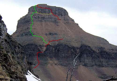 Red - Southwestern Talus Slope Route Green - Southwest Ridge Yellow - traverse variation