
|
|
Route |
|---|---|
|
|
37.82450°N / 107.807°W |
|
|
Hiking, Mountaineering, Scrambling |
|
|
Spring, Summer, Fall |
|
|
Most of a day |
|
|
Class 4 |
|
|
Class 4 |
|
|
Approach
The starting point is South Mineral Campground and trailhead. This parking area is fairly spacious and will accomodate over 40-50 vehicles. However, due to the extreme popularity of Ice Lakes Basin, this area will fill up quickly with overflow vehicles parking down South Mineral Road. Of course, weekends will always be busier. Play it safe and arrive for Grant early to avoid this hassle. Plus, you'll want to start early anyway as Grant and this ridge offer no easy escape in case of storms.
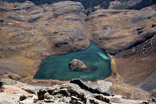
Start by hiking up Ice Lakes Trail for about 2.2 miles to an unmarked junction. From this junction, you have two choices. If you stay left and take this approach, the trail will take you to Ice Lakes proper. This is about an additional 1.4 miles. Once at the lake (actually, a short ways before), take a right hand side trail across the tundra and over/through the outlet stream. This will connect with the Island Lake Trail. Continue on this for .6 mile and about 200' passing the remnents of the Golden Gate Mine (12,188') to Island Lake.
Option two takes the right hand fork and quickly gains elevation towards Island Lake. Some people refer to this alternative trail as the Swamp Pass Trail as it avoids the Ice Lakes all together. Expect about a 1.1 mile ascent. This trail passes by the rements of an old unnamed silver mine. Either way, both trails are beautiful in summer and fall as wildflowers are everywhere.
At Island Lake, follow the good trail around the lake on the south side and aim for a large boulder with a cairn built on top. It's located on the far western side of the lake near the dry (typically) inlet. Start your ascent of Ulysses S. Grant from here.
Route Description
Leave the west side of Island Lake (12,400') heading due west up the scree & tundra slopes to the obvious saddle of V4 and Grant. This slope ascends about 810' to the saddle at around 13,210'. Near the top, the scree gives way to hardpan dirt, so be careful.
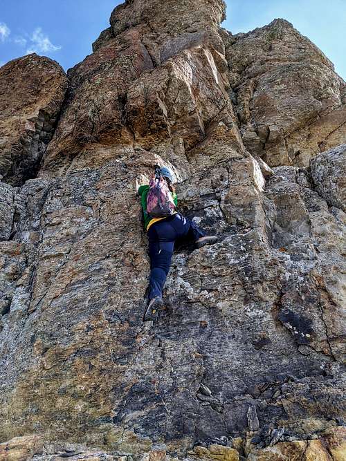
From the saddle, the summit of Grant is only a paltry 557' above you and roughly .3 mile. This is a fairly short ridge but absolutely the easiest way in getting to the apogee. In terms of breaking it down, expect loose, small blocks of rock & large scree lower down. There's a 4th class (short) climb up a cliff to a ledge which kind of acts as the half-way point followed by a fun, little scramble on gray, flaky rock to a summit ridge. Like I said, its a short ridge but very enjoyable.
- Hike/scrambleup the loose but mellow ridge. There is a social trail that winds up this lower half of ridge with [unnecessary] sporadic cairns. Eventually the loose trail starts to weave in and out of croppings and bulges of that gray, flaky volvanic rock I alluded to earlier. Pass through and around these mini-towers until the route starts to even out. You'll see a small notch you'll have to scamper through. Past this notch, the cliff band is straight ahead. The views of V4 (13,540') to the northwest from here are astounding.
- There are two ways up this short cliff band. The left option has in my opinion, better holds and more choice. It is generally regarded as being the easiest choice. The right option has fewer holds and tends to be smaller. Although in terms of difficulty, both options are negliable. Both weaknesses are only a few feet from one another and the actual climbing is only maybe 15'. Scamper up onto the good ledge and follow climbers right around a slight bulge in the wall to a shallow gully on the left.
- Scramble up this shallow gully (slightly easier if you keep to the left) on that same gray, flaky rock. The volcanic roack has an odd consistancy in that, the end pieces break off easily but the majority stays somewhat solid. This is a super short 'pitch' but fun scrambling.
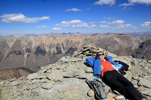
- AT the top of this gully, the summit is now visable. Walk the remaining 75'-100' to the summit and enjoy the views. Grant is perhaps the second hardest of the Ice Lakes peaks, but not many people make the trek up there. Chances are you'll probably be alone on this one.
Essential Gear
This ridge and peak are a scramble, NOT a climb. It is not necessary to bring a rope for this peak. Any proficient scrambler can navigate up and down the cliff just fine. 90% of this ridge is nothing more than a class 2 walk up. So saying that, just have a sturdy pair of boots with you. Even trail-runners/approach shoes could make this ascent, albeit slightly sore feet. Standard mountain fare should be adequete.

Miscellaneous Info
|
Here are a few trip reports from various sites:
|
And here are a few external resources from various sites:
|

|
|
 |

|