Approach
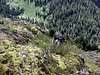
![Liberty Mountain]() Liberty Mountain's SE ridge
Liberty Mountain's SE ridge
Follow SR-92 east to Granite Falls, turn onto the Mountain Loop Hwy and continue east for about 6-7 miles and turn left (north) on Tupso Pass Rd (FS Rd #41). You have two choices from here:
Option 1. When the pavement ends, turn right onto Rd 4110 and follow for 1.3 miles and turn right onto FS Road #4111 and follow this as far as you can (the road is washed out at about 7.8 miles and you will have to hike or bike the rest). Biking this is difficult due to treefall and washouts. Just before the old Canyon Lake Trail, the road will fork. Take the left fork and continue on the old road until it crosses into the Canyon Creek valley.
Option 2. When the pavement ends, continue up the hill to the left. Follow this road for about 6 miles, you will go around a sharp hairpin turn to the left over a creek where the road will noticeably dip down. Soon after you will see a road fork to the right. Park here or keep driving if you don't care about your car's paint. You won't be able to drive very far anyways. This is Road #4130, which later branches into 4130 (downhill branch) and 4131 (uphill branch). Note: you can ride your bike up Rd 4131, but it is difficult to get across the large road washout with it, and shortly after the washout the trees and brush will become too thick to ride much further. Either road will work, pick your poison. The bushwhacking will be rough either way. The uphill road (4131) will get you closer to Liberty but requires some elevation loss.
Route Description
Once you are in the valley of the South Fork Canyon Creek and West/Southwest of Liberty Mtn, descend the steep and heavily forested hillside E/NE about 800 vertical feet, until you reach the creek. It can be difficult finding a log crossing, you may have to get wet! Ascend through open old growth towards the southwest ridge. As you ascend the hillside will become progressively steeper and the devils club and other nasty vegetation will become very thick making travel very slow. Continue up along the ridge through thick stands of small trees and steep rock until you break from the trees and ascend a very steep heather slope. Soon the summit block will become visible, scramble up it to the top (class 3/4). Be cautious of the east face, it is a LONG ways down. Downclimb or rappel back down from the summit.
Essential Gear
A rope might be nice for the summit block if you aren't comfortable downclimbing class 3/4. Keep your pack light & compact for thrashing as you will be bushwhacking through dense head-high devils club. Leather gloves are highly recommended. Pack a bivy sack or tarp shelter if you plan to overnight (no room for a tent). Be prepared for steep snow climbing if you go any time other than summer. The summit would likely be quite exposed.
Miscellaneous Info
If you have information about this route that doesn't pertain to any of the other sections, please add it here.

 4595 Hits
 71.06% Score
 1 Votes
 Liberty Mountain's SE ridge