
|
|
Route |
|---|---|
|
|
40.78570°N / 110.4903°W |
|
|
Hiking |
|
|
Summer, Fall |
|
|
A long day |
|
|
Class 2 |
|
|
Overview
Virtually all of the trails in the Uinta Mountains of Utah are graded for horses. The trails stay mainly in the valleys and cross ridges at low points. Popular destinations are any of the hundreds of beautiful lakes found in this region. Relatively few hikers venture off-trail except to climb Kings Peak, the state highpoint, and Gilbert Peak, the Summit County highpoint. There are miles and miles of ridges with prime views that go unseen. Many of the ridges have steep sides with few easy access points, but once on top, it's smooth sailing. This page describes a route along the length of the Squaw Benchmark Ridge that roughly parallels the Henrys Fork Trail (the most common access to Kings Peak and Gilbert) and is a little over 6 miles to the west of that trail.Exceptional views are had from the ridge of some seldom climbed Uinta Peaks. To the east is Red Castle, which may or may not look red depending upon the time of day and angle of the sun.
 Red Castle not looking too red from the west at 12:30PM Red Castle not looking too red from the west at 12:30PM |  Looking northeast at Red Castle at 1PM Looking northeast at Red Castle at 1PM |
To the southeast lies Wilson Peak with its very steep north face and .6 mile long almost flat summit ridge.
 Wilson Peak
To the south are Porcupine Mountain, South Porcupine Mountain, and Stone Benchmark, three little known 12000 footers, that are viewed over the barren Oweep Basin, a seemingly flat expanse.
 Porcupine and South Porcupine Porcupine and South Porcupine | 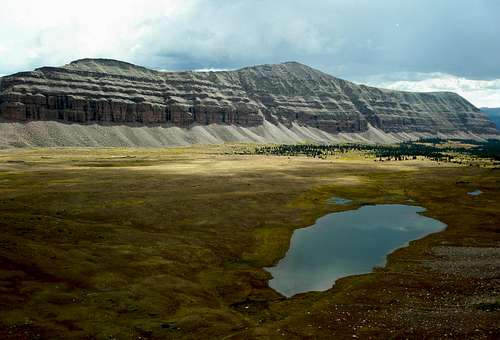 Stone Benchmark Stone Benchmark |
To the southwest and west are Oweep and West Oweep Peaks and the Blacks Fork Ridge, a total of six more little known 12000 footers.
 The Oweeps and the southern end of the Blacks Fork Ridge
The route is 21 miles long with 4700 feet of elevation gain and can be completed in one long day. The route is comparable in difficulty to climbing Kings Peak in a day, but unlike the route to Kings Peak, which is teeming with state highpointers and boy scouts in the summer, it is unlikely that you will see anyone. The ridge crest is surprisingly easy to walk on, given how narrow it is in sections and how steep its sides are. It is a hiker's delight and is almost as easy as walking on a sidewalk, strewn with occasional bricks. The northern end is primarily soft tundra and the southern end is primarily rocky, but even in the rocky sections the footing is typically not difficult. As you travel south on the ridge, everything in front of you will be a brownish shade, but if you look behind you, everything will have a distinctly reddish hue.
 Looking ahead/south to Point 12960 and Point 12678 Looking ahead/south to Point 12960 and Point 12678 |  43 minutes later, looking back/north from Point 12678 at Point 12960 43 minutes later, looking back/north from Point 12678 at Point 12960 |
Stats
Total mileage: 21.1 milesTrail mileage: 12.2 miles
Off-trail mileage: 8.9 miles
Total elevation gain: 4700'
Lowest elevation: 9350'
Highest elevation: 12990' Squaw Benchmark
Getting There
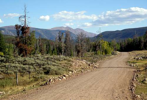 Driving to the trailhead you can see the Squaw Benchmark ridge on the left
The route starts from the East Fork Blacks Fork Trailhead located on the north slope of the Uintas.
Take I80 to exit 34 in Wyoming and head to Fort Bridger. Go 5.3 miles to a blinking red light. Turn right on Wyoming state route 414 and go 3 miles to Wyoming state route 410. Turn right onto 410 and follow it for 13 miles. First you will see a sign that says the pavement ends in 750 feet. Shortly you will see another sign for "Blacks Fork River Access Area" and then another one that says "Wasatch Nat'l Forest/Meeks Cabin 13". If you miss the signs, don't worry, the three sets of rumble strips should wake you up. Do as the signs say and turn left. The road you turn onto starts out paved but soon changes to dirt. Follow the main road 23.6 miles to the signboard (just past a gate) for the East Fork Blacks Fork Trail. The trail start is just before the signboard. There is no parking right at the trail start. Instead, continue on the road for just a few feet and turn right and then left into the parking lot.
On the Wyoming side, the dirt road is beautifully graded and maintained and you can make good time. Once it crosses the Utah border it gets noticably worse and once it passes the intersection with the dirt road headed for the Mirror Lake Highway, it gets worse still. It's somewhat rocky but is fine for passenger cars if you go slow.
Views of the Ridge
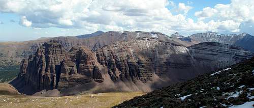
The Squaw Benchmark Ridge is either very red or not, depending upon the time of day and angle viewed. The first two pictures are views from the north in the morning and the other three are from the south in the afternoon. The Squaw Benchmark Ridge is the frontmost. From the northwest
 From the north "ridge" of Mount Powell, from the northeast
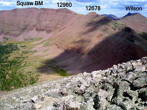 The southern end, from the southwest
 The very southern part of the ridge ranging from Point 12678 to Squaw Pass, from the southwest
 From the summit ridge of Wilson, from the southeast
Route Description in a Nutshell
Start at the East Fork Blacks Fork Trailhead, bushwhack up to the Squaw Benchmark Ridge, follow the ridge over Moose Peak (12780'), Squaw Peak (12686'), and Squaw Benchmark (12990') to Point 12960, turn west and follow the main Uinta crest west over Point 12678 to Squaw Pass, and then take the Little East Fork Blacks Fork and the East Fork Blacks Fork trails back to the trailhead.Route Description
Note that waypoints are provided on the map. Bear left after crossing this bridge. Bear left after crossing this bridge. Leave trail here and head for the ridge Leave trail here and head for the ridgeStart at the East Fork Blacks Fork Trailhead. After .2 miles you come to the junction with the Bear River Smiths Fork Trail. Continue straight on the East Fork Blacks Fork Trail. Shortly after the stream crossing shown at left, at 1.4 miles from the start, bear left onto the Little East Fork Blacks Fork Trail. There is no sign, but if you look for it, it should be obvious. Follow the Little East Fork Blacks Fork Trail for 1 mile until you reach the middle of the meadow shown at right. Leave the trail and head generally for the wide saddle south of Bald Mountain. The trees are dense and you won't be able to see your destination, so a GPSr or compass would be useful. If you are lucky, you will come across a few sections of open rocky areas. Bushwhacking is not for everyone and if you don't like it, you can avoid it by doing the Bald Mountain Variation which is a little longer, but involves no bushwhacking. |
 Most of the way the bushwhack looks like this. Most of the way the bushwhack looks like this. | 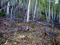 There's lots of deadfall. There's lots of deadfall. |  Sometimes it's a rats nest. Sometimes it's a rats nest. |  A few treeless rocky sections are encountered. A few treeless rocky sections are encountered. |
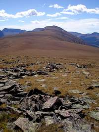
The terrain is at a moderate grade for the first 400 vertical feet and then steep for the next 1000 vertical feet where tree line is reached at about 11000'. After another steep 200 feet, the terrain flattens dramatically and you reach a wide ridge covered with easy walking tundra. Glimpses may be had of the very tops of Gilbert and Powell, but mostly, all you see in this section is tundra.
Head south on the ridge towards Point 12611 and then the unofficially named Moose Peak. Gradually the terrain transitions between solid tundra and a mix of tundra and stable rock that is still fairly easy to walk on. After you crest Point 12611, you'll get good views of Red Castle, Red Castle Lake, and Mount Wilson all to the left of the ridge. The further south you go on the ridge, the better these views get. In general, views looking forward/south will be brownish and views looking back/north will look varying shades of red. If you turn around, you will see Bald Mountain, which is such a gentle summit, that even though it rises 356 feet from its south saddle, you'd never know it from a picture.
 Finally you top out on a wide, tundra filled ridge Finally you top out on a wide, tundra filled ridge |  Moose Peak lies ahead Moose Peak lies ahead | 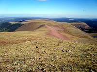 Turn around to see Bald Mountain Turn around to see Bald Mountain |
The next point on the ridge with over 200' of prominence is the 12686 foot, unofficially named, Squaw Peak. After reaching the summit of Squaw Peak and descending the other side, there are several small bumps to go over and then at last, you are on the final uphill to the highpoint of the ridge, Squaw Benchmark (12990'). Note the contrast between south and north views.
 Squaw Peak lies ahead Squaw Peak lies ahead |  Moose Peak lies behind Moose Peak lies behind | 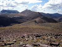 Lots of little bumps to go over Lots of little bumps to go over |  Looking back at Squaw and Moose Peaks Looking back at Squaw and Moose Peaks |
 Approaching Squaw Benchmark and Point 12960 Approaching Squaw Benchmark and Point 12960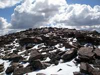 The summit stick on Squaw Benchmark The summit stick on Squaw BenchmarkThe ridge gets more interesting as Squaw Benchmark is approached. It narrows and its steep west side is prominent. There is no more tundra, just rock. Yet, it is still easy class 2 at the very most. |
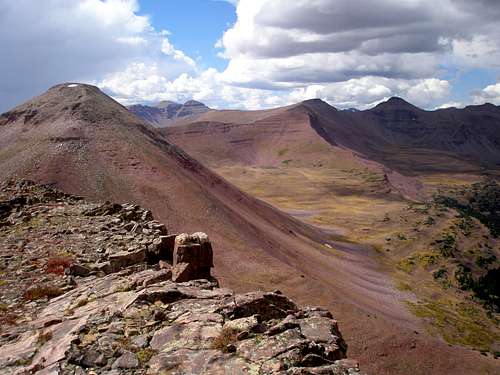
From the benchmark, it is just a short distance to Point 12960, where the ridge forks. To the southeast lies the saddle with Wilson Peak and to the southwest lies Squaw Pass and the Little East Fork Blacks Fork Trail. Turn southwest and head to Squaw Pass.
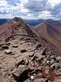
 Looking forward/south to Point 12960 Looking forward/south to Point 12960 |  Squaw Pass is at right Squaw Pass is at right |  Who would guess the top is so easy with the sides so rugged Who would guess the top is so easy with the sides so rugged | 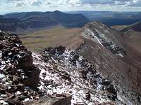 Looking ahead to Squaw Pass from Point 12960 Looking ahead to Squaw Pass from Point 12960 |
From Point 12960 to Squaw Pass the ridge is at its narrowest in spots, yet there are sections where the crest of the ridge is almost flat. There is one minor uphill along the way, Point 12678, which is the last of the elevation gain. The rest is all downhill.
 Looking ahead to Point 12678 Looking ahead to Point 12678 |  Looking back towards Wilson Peak Looking back towards Wilson Peak | 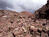 A rocky stretch A rocky stretch | 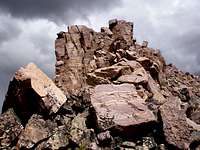 Looking back at an outcrop on the ridge Looking back at an outcrop on the ridge |
At Squaw Pass you meet up with the Little East Fork Blacks Fork Trail which is followed for 8.4 miles until you reach the East Fork Blacks Fork Trial. The trail starts out very open and dry with lots of views and stays like that for a long way. Eventually the woods are reached and there are some occasional muddy sections, but the trail is good for the most part and is far less swampy than the East Fork Blacks Fork Trail. There are 4 major stream crossings, all of which have great logs.
 The trail is very open for a long way The trail is very open for a long way |  Looking back at Squaw Pass, Squaw BM Ridge left. Looking back at Squaw Pass, Squaw BM Ridge left. |  A muddy section through the woods A muddy section through the woods |  A more typical section through the woods A more typical section through the woods |
When you reach the East Fork Blacks Fork Trail, follow it 1.4 miles back to the start.
Variations
Bald Mountain Variation
To avoid the bushwhack up to the ridge, you can take a round about trail that goes almost all the way to Bald Mountain at the north end of the ridge and pick up the ridge there. This trail is well maintained and is at a very gentle grade. The disadvantage is that it would add 1.7 miles to the trip and another 356' of elevation gain, but the obvious advantage is that it skips the bushwhack.
The start is the same as for the main route. Shortly after crossing the bridge at the beginning you will reach the intersection with the Bear River Smiths Fork Trail. Turn left on that trail. After .8 miles you come to another intersection. A left will take you to a ford of the creek. Continue straight on the trail signed "Red Castle". The trail makes 5 major switchbacks and then becomes almost flat. Another intersection is reached after 1.7 miles and you turn right onto the trail signed "Bald Mtn Trail". Follow this trail as long as is convenient and then head directly for the summit of Bald Mountain which is a distance of 5 miles from the trailhead. After reaching Bald Mountain and descending the other side, you will be on the main route.
Note that Bald Mountain is such a gentle summit that it may not be clear exactly where to head unless you use some navigational aid. However, once you are on top, its highpoint is obvious and comes complete with a large cairn, a benchmark, and a comfortable wind shelter.
 The trail to the north ridge of Bald Mountain The trail to the north ridge of Bald Mountain |  Looking back/north on the way to Bald Mountain Looking back/north on the way to Bald Mountain | 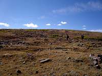 Approaching the summit of Bald Mountain Approaching the summit of Bald Mountain |
Squaw Benchmark/Blacks Fork Ridge Combo
The Squaw Benchmark ridge is east of the Little East Fork Blacks Fork and the Blacks Fork Ridge is west of it. There is a similar page for the Blacks Fork Ridge Loop that traverses that ridge and comes back via the Little East Fork Blacks Fork Trail just as this route does. One could start out on either route, and instead of returning via the trail that is in the middle of the two, one could return via the opposite ridge. The mileage would be about the same but there would be about 3000 more feet of elevation to gain. Note that the Blacks Fork half is rougher than the Squaw Benchmark half and there are more ups and downs on that ridge.
 The north end of the Blacks Fork Ridge The north end of the Blacks Fork Ridge | 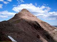 The middle of the Blacks Fork Ridge The middle of the Blacks Fork Ridge |  The final two peaks before Squaw Pass The final two peaks before Squaw Pass |
Maps
Note that the terrain at the very north end of the maps isn't as steep as it looks because at that end, the contour interval is only 20' vs 40' elsewhere.The red lines are trails and the blue lines are off trail sections.
 Main route Main route |  Bald Mountain Variation Bald Mountain Variation |  Squaw Benchmark/Blacks Fork Ridge Combo Squaw Benchmark/Blacks Fork Ridge Combo |
Mountain Weather
 Looking west at 8:41AM Looking west at 8:41AM Looking west at 1:55PM Looking west at 1:55PMA typical summer day in the Uintas dawns without a cloud in the sky. By mid morning faint wisps of clouds are seen on the horizon. By midday the sky is half full of big puffy clouds. In the afternoon the sky is mostly overcast and possibly raining, but by early evening blue sky makes a comeback. Afternoon thunderstorms are frequent. Here is a link to the current 7 day forecast for the Squaw Benchmark Ridge. |
Essential Gear
Nothing special is needed except a GPSr or a compass is useful for the bushwhack section.Red Tape
Red Tape The East Fork Blacks Fork Trailhead
Normal wilderness area restrictions apply. Check the signboard at the trailhead for the most uptodate information.
Camping
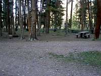 The campground
There is a free campground at the East Fork Blacks Fork Trailhead. There are 7 official sites all of which have fire pits. Four of these have picnic tables and three do not. Even on weekends, I've seen at most three sites in use. There is no water so you need to bring your own.