
-
 7073 Hits
-
 75.81% Score
-
 6 Votes
|
|
Route |
|---|---|
|
|
39.15420°N / 105.5835°W |
|
|
Hiking |
|
|
Spring, Summer, Fall |
|
|
Half a day |
|
|
Class 1 walk up, route-finding/navigation |
|
|
Overview
Though a majority of the mileage of this hike is on an old logging road, the fun kicks in for the short bushwack to the rarely-visited summit.Getting There
From Colorado Springs: Hwy 24 West to Lake George. Just past lake George, turn right (northwest) on Park County 77 (Tarryall Road). Use caution with the minefields of potholes. Between dusk and dawn, deer and elk are incredibly numerous - watch your speed! Just before the Tarryall Reservoir, turn left on Park County 23 (Turner Gulch Road). Follow Park County 23 1.6 miles and turn left onto FS 144. Take FS (Forest Service Road) 144 4.5 miles to the junction with FS 237. Bear left/east at this junction and continue until a parking area where the road makes a sharp right, crosses a stream (Pack Creek) and heads into deep woods. There is no sign for this trailhead. Parking is ample with respect to the small volume of fellow trail users.From Denver: Take Hwy 285 to the town of Jefferson and turn left on Park County 77 to the Tarryall Reservoir. (Keep an eye out for free range cattle.) Just southeast of the reservoir turn right on Park County 23 (Turner Gulch Road). Follow Park County 23 1.6 miles and turn left onto FS 144. Take FS (Forest Service Road) 144 4.5 miles to the junction with FS 237. Bear left/east at this junction and continue until a parking area where the road makes a sharp right, crosses a stream (Pack Creek) and heads into deep woods. There is no sign for this trailhead. Parking is ample with respect to the small volume of fellow trail users.
For Park County 23 and FS 144, high clearance is a must but 4x4 is a nice-to-have unless the roads are wet. If the roads are wet, do not proceed without 4-wheel drive.
Route Description
Approximately round trip mileage: 6.5 milesApproximate elevation gain: 1,870 feet
This route description is approximate and is meant to compliment a detailed topgraphical map. Nothing can compensate for your own, well-honed navigation skills, aided by map & compass and GPS.
- From the unsigned Packer Gulch trailhead at 9,700 feet, continue by foot on FS 144 west across Pack Creek into the woods.
- Follow FS 144, switchback after switchback, for approximately 2.5 miles.
- The road ends at the summit of the saddle between Puma Peak and Little Puma Peak.
- Turn southwest (to your left) and bushwack up the hill to the summit, hurdling downed logs and stepping over rocks.
- You'll know the high point when you see it.
- Puma Peak provides a roomy summit area perfect for relaxing and grabbing a bite to eat. The views, while not wide-open 360 degrees, are pleasant in the company of gnarled old pines.
- Long pants. I strongly recommend against shorts for this hike through deep woods and fallen timber over a rocky slope.
- Topographic map
- Compass
- GPS
- Colorado Atlas and Gazetteer (for backroad navigation)
- Trekking pole(s)
- Sturdy hiking boots with grippy soles and stiff ankle support
- More water than you think you will need (these are dry mountains)
- First aid kit
- Other standard backcountry essentials (if I have to list these for you here, you probably should not navigate trail-less summits)
NOTE: SPer Jeremy Hakes notes that there is disagreement as to which summit is the highpoint of "Puma Peak." Some content the eastern highpoint (with a stated elevation of 11,550 feet on the map) is actually higher that the western summit (that appears, per the map, to be the highpoint). Ensure you visit both "humps" to be thorough!
Essential Gear
For safety and comfort, the following are recommended:Map
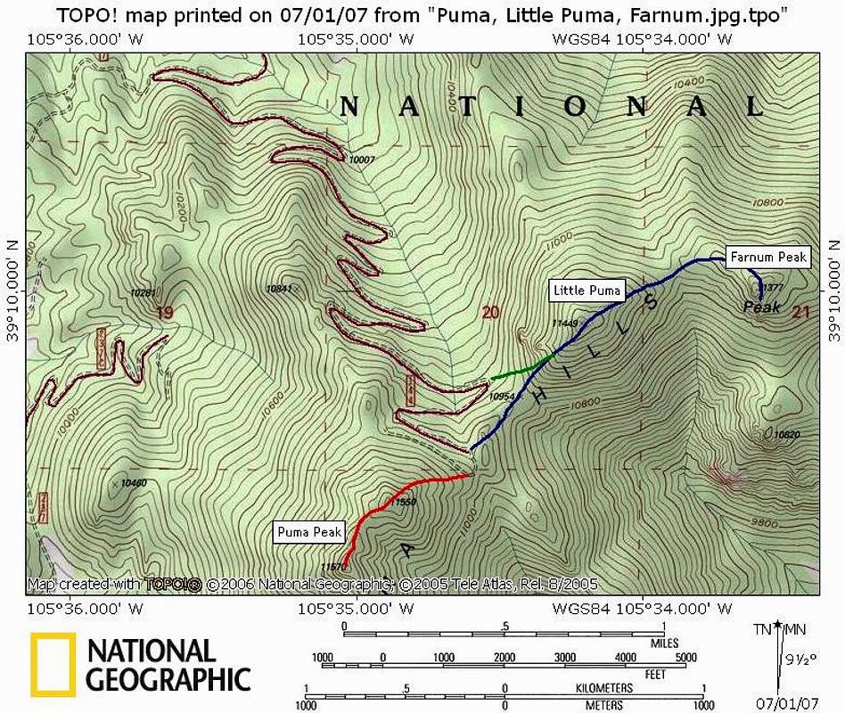
The below topo map illustrates routes from the saddle summit of FS 144 to:Puma Peak, 11,570 ft -- Red
Little Puma Peak 11,449 ft -- Blue = primary route; Green = shortcut (easy to use going up, but tough to nail on the return)
Farnum Peak -- Blue
External Links
Pike & San Isabel National ForestsPike National Forest Recreation Map