
|
|
Route |
|---|---|
|
|
40.01500°N / 107.0832°W |
|
|
Hike |
|
|
Half a day |
|
|
Class 1 |
|
|
Approach
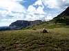
Start from the Parking lot at Stillwater Resevoir.
Route Description
Procede on the trail for about 50 yards until you reach a fork. Take the trail to the left and follow it along the south side of the resevoir. The trail then leaves the shore and heads south into the woods. Sign the trail register and continue through the woods on the well defined trail for about 1.5 miles. Once above tree line, you will reach a saddle where the terrain flattens. At this point the trail splits again. Do not continue straight on the main trail as it will take you downhill to Hooper and Keener lakes. Take the lesser trodden trail that goes sharply left. This trail continues for another 1/4 mile and then vanishes. Follow the gentle slopes for another 1.5 miles to the summit.
 |  |  |  |  |
Essential Gear
Be prepared for all kinds of weather. It can snow in July above 12,000 ft. Summer afternoon thunderstorms are common, so start early.