
|
|
Route |
|---|---|
|
|
37.48946°N / 118.79647°W |
|
|
Download GPX » View Route on Map |
|
|
Hiking |
|
|
Most of a day |
|
|
Class 2 |
|
|
Overview & Trail Description
Route (with variations) as seen in Google Earth:

Probably the most popular trail to Mount Stanford North out of Little Lakes Valley is the Hilton Lakes/Davis Lake trailhead above Rock Creek Lake:
 Hilton Lakes Trailhead Hilton Lakes Trailhead | 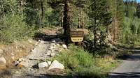 Hilton Lakes Trailhead Hilton Lakes Trailhead |
From this trailhead, climbing Stanford North involves a round trip of approximately 15 miles with a total elevation gain of about 4,500'. (The net gain is only 3,000', but there are plenty of ups and downs.)
There are a couple of shortcuts that will reduce the round trip to 12 miles and 4,200' elevation. The first shortcut is to take the unsigned trailhead across from the Pine Grove Campground:
 Pine Grove trailhead Pine Grove trailhead |  Pine Grove trailhead Pine Grove trailhead |
From here the trail climbs 550' in 0.6 miles to join the main trail. Compared to the main trail you save almost 2 miles roundtrip on an up-and-down trail that's been pounded into soft sand by pack animals, at the cost of perhaps 100-200' additional elevation. The trails join here, at what is probably the best chance of finding water before Hilton Lakes:

Pine Grove/Hilton trail junction
The next shortcut is approximately 3 miles from the Pine Grove trailhead, where the trail drops to a junction with Davis Lakes, then immediately climbs back up to the Hilton Creek lakes. If you leave the trail here and follow a contour line towards Hilton, you’ll have to do some easy rock-hopping but on the round trip save a mile and some 400’ of elevation:

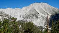
As you approach this shortcut you get good views of Morgan North:
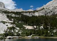
Just after the shortcut you reach the first of the Hilton Lakes:
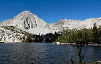
Continue on to the next lake, Lake 10,350, where the trail ends and you continue up the stream feeding into the lake:
Bob Burd notes that when ascending from Lake 10353, “A very nice use trail follows the creek on the right (north) side for the first mile or so through the heavy vegetation here. It is worth a few minutes to locate this trail before heading blindly up through the brush unless one enjoys bushwhacking to a high degree.”
Secor: “From the north shore of Lake 10,353 of the Hilton Creek Lakes, ascend a stream that goes west-northwest toward the saddle that is south of Stanford Lake. The low point of the saddle is best bypassed; instead, head for the far western edge of the saddle, climbing it via a chute. Go north and ascend the final east slope over a false summit to the true summit of Mount Stanford”.
Secor's route was too steep for my comfort. I climbed along the southern edge of the ridge as recommended until it got steep - I then cut across the ridge and found myself a couple of hundred feet above an unnamed lake above Stanford lake, and the ascent to "the final east slope over a false summit" looked scary. Instead I dropped back down to the lake and cut right up the next ridge into a hanging bowl. On my return, the low point in the saddle seemed the easiest route -- as also noted by Burd (report). On the approach from Hilton Lakes I would recommend aiming for the saddle, angling to the right over the following ridge, then hiking by the unnamed lake and angling right again up the next ridge into the hanging bowl above Stanford lake.
As Patty Kline noted (report), the summit of Stanford is not visible until you are almost upon it. While climbing up the hanging bowl you can see Peak 12,931 to the right, 100' higher than Stanford and visible from lake 10,350 (photo above), as well as for most of the ascent from there. [Perhaps Peak 12,931 should be the named peak? Or maybe they should call this one Stanfurd? :) ] On the left, the unnamed point above the unnamed lake -- Secor's "false summit" -- is another tempting but incorrect target; the shoulder of Stanford appears as a low bump on the ridge to the right of this point.
The summit pile has a short easy rock ladder on the north side that puts you on the summit.
Getting There
For directions to the trailheads at Pine Grove and at Rock Creek Lake, see the page for Mount Stanford North:Mount Stanford North