Another Nevada treasure
Star Peak, the highpoint of Pershing county had been on my list for some time. While only 9836 feet high, it is the highpoint also of the Humboldt mountain range and is one of 57 peaks in the US considered
an ultra. I had a trip planned to Las Vegas in the middle of October and hoped that I could bag it on the way down. The catch was that my wife would have to sit in my truck all day long as I pursued my goal of reaching the summit and Chukar season would be starting on the same day that I would be there. Guns would be going off all day around her so I wasn't sure she would go for it. When she agreed to what I had in mind, the trip to Star Peak was on. Yea !!

Nevada image thanks to
Pershing county historical society
I have been chasing the
county highpoints of Nevada and had just two left to complete the state, the other being
Mt. Grant of Mineral county. I had started on them three years before and each year I was able to get at least three or four of them. The beautiful thing about doing the county highpoints is that you really get to see a state that way. Nevada is full of mountain ranges, in fact, it has more mountain ranges than any other state in the U.S. Many of these ranges are pure desert but surprisingly, many have wonderful ecosystems that amaze you when you visit them. Pine trees, lakes, running streams and bountiful animal life are to be found in more ranges than you'd expect. It is easy to fall in love with Nevada and you can count me as one who has.
We left our home in Washington state early friday morning and drove to Winnemucca Nevada where we stayed at a motel for the night. Then early saturday morning, we were on the road, heading for the eastern side of the Humboldt range, the Star City area to be exact. Most of the people that I knew who had climbed Star Peak had done so from the west side via El Dorado canyon. A road takes you up to a mining camp and if you have the right rig you can drive even closer to the peak, sometimes getting to within a mile and a half and less than 1300 feet from the summit. It takes a jeep like vehicle to do so as many of the hairpin turns are too tight for a bigger vehicle (like my Tacoma). However, the road leading into the canyon had suffered a wash out the year before and it now required that you hike from a much further distance with a much greater elevation gain needed to be successful.
![Star Peak & Thunder Mtn]() Star Peak from the jct with NV 400
Star Peak from the jct with NV 400
I had heard from
Paul Burkholder that
he had climbed Star Peak a couple times from the eastern side, via Star Creek canyon. My research was aided by a couple emails from Paul wherein he described the way he went to me. He had gone up from a 4WD road that
ended here and then ascended a steep class 3 gully to the summit area. I considered that but in studying the maps, I felt that a way that looked promising was the ridge between the Silver Star mine and the Desoto mine. It looked like I could park near where Star City used to be and walk up the Queen of Sheba mine road to access that ridge. My studies received a huge help when
Spence put up an album on his trip to the
Humboldt range. A
panoramic picture he took from the top of Van Zandt peak showed the ridge I was considering in its entirety and it was obvious that that way would work.
Technically there was nothing difficult about this route, mainly class one or class two hiking but no class three. Pretty much one of those hikes where I could expect to put one foot in front of the other and enjoy the scenery.
The drive and the hike
The drive from Winnemucca was pretty straightforward, as the total distance from where we stayed to the trailhead that I used near the old Star City was about 40 miles. A good chunk of it is on I-80, then another 8 miles or so to a historical sign
![Star City historical sign]() Historical sign about Star City
Historical sign about Star City that tells about Star City. From the sign, it is 4.8 miles to where I parked but only the last mile and a half was the kind of road that my wife really doesn't enjoy. Narrow, rutted and drop offs in a few places and no room to turn around if you met another vehicle coming the opposite direction, in other words, my kind of road. When we got to the area where you could spot the Star City ruins, two pick up trucks were parked over there and I found a convenient spot just off of the road that had plenty of room. I didn't feel it appropriate to go over and park next to those other two trucks since one of them had a guy relaxing in a camp chair while the occupants of the other truck were out hunting.
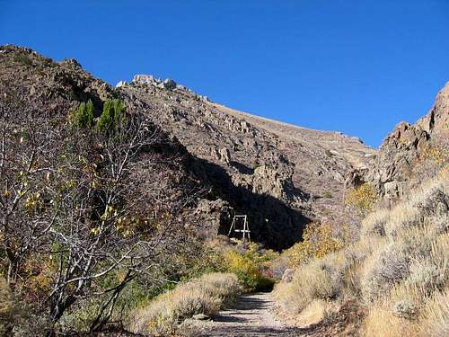
![The remnants remain]() This mining tram was about 1000 feet from where I parked my truck
This mining tram was about 1000 feet from where I parked my truck
I gathered together my gear, put my boots on and handed my wife a walkie talkie that would enable us to make contact when I was about half way up the mountainside and headed up the road that led past the Queen of Sheba mine.
About 1/4 mile up the road, I met the two guys and their dogs who were in a pickup over near the Star City ruins. We had a nice discussion and one of the hunters shared a couple tidbits about the area above the Silver Star mine. From what he said, I felt good about my decision to just take the ridge all the way up to the saddle instead of trying to hike up the road to the Silver Star mine and hike over to the ridge from there.
The road kept getting worse and really became an ATV track more than anything else. At about the mile mark, I passed by the
Queen of Sheba mine but didn't take the time to go and explore the area around it at all. Eventually
the road became not much more than a boulder walk as some flash floods had taken out the road higher up. It was at this point where I just headed straight up the ridge and found my way through
the tangle of brush.
Game trails were all over the place so route finding was no problem, I just kept as much as I could to the best path and only occasionally had to resort to brush bashing.
![Looking down the ridge]() Looking back down to the Queen of Sheba road
Looking back down to the Queen of Sheba road
Once on top of the first part of the ridge at 7000 feet, I just made my way up the ridge, steep in places but nothing ever technical or difficult. The brush in this area was about waist high and remained that way for the next thousand feet where it dropped in size and became even easier to make my way through without thinking much about it. As I closed in on the saddle at 9097 feet, the brush was often only a bit above my ankles to mid calf and posed no problem at all.
![A dusting of snow]() The antenna that topped the adjacent ridge
The antenna that topped the adjacent ridge
On the opposite ridge to the east, an antenna structure topped out on it and I could see that a person could easily ascend/descend that ridge as well. I even thought about doing a loop and going down that ridge but
I had given my wife a map with my route on it and I felt it best to stick
with it.
I had GPS'd pre set coordinates and they led me nicely to the saddle at 9097 feet where for the first time, I could actually see the summit of Star Peak. The view just from here was outstanding but I had less than a mile and less than 700 feet of elevation to gain and it was a no brainer to put this one behind me. I had to go over and inspect the BLM antenna set up that seemed very much out of place and was relatively new to this mountain area. Paul Burkholder had mentioned that they choppered in all of the materials necessary for its construction sometime in the 2003-2004 winter and yet it was nice that it wasn't right on the top of Star Peak, I appreciated that. The summit of Star Peak is nothing dramatic and yet the view is. Check out
this panoramic view that
Spence took and you'll see what I am talking about.
I did not linger at the summit but rather headed right back down the way I came since my wife was waiting for me in the truck. I made walkie talkie connection with her as I was heading down and moved as fast as I could since it had taken me longer than I had expected to get to the top. I had left the truck at 9 a.m. and reached the top at 1:30. I figured it'd take me two and a half hours to get down and then we'd just make it in time to get to our motel room in Fallon Nevada before dark. It did take that long but partly because I ran into two hunters on an ATV on the Queen of Sheba mine road. They were two brothers and the older one knew SP's
Barry Beck and mentioned him as one who loved to climb Nevada peaks with his friend Scotty. It seemed that Barry worked with this guy at one time many years before. Now I wish I had written the hunters name down but I committed his name to memory and that was where I made my mistake. My 66 year old brain just doesn't have that great memory it used to have. Of course, I normally carry a pen and a small notebook but that was sitting in the truck with my wife where I needed to get to. My wife was much relieved to see that I hadn't been eaten by a big cougar that a hunter named Vince had mentioned to her while I was climbing the mountain. Nope, I didn't even see any cougar tracks up there. I did see plenty of Chukars, mainly in areas where the hunters had just been. : )
![From the summit of Star Peak]() From the summit area looking north
From the summit area looking northMap of route
![Map of Ridge Route]() click on map twice to get largest size
click on map twice to get largest size
An additional map of the area can be found
HERE.
I noted that it was 40 miles from Winnemucca but I also checked to see how far it was from there to Lovelock and it turned out to be 55 miles from the trailhead to McDonalds. Hey, a guy's gotta eat and that Big Mac tasted mighty good. I even went overboard and had fries with it (bad food, bad food)
One more comment, when I drove by Mt. Grant on the way to Las Vegas, I really
really really wanted to stop and get it. It had a nice smattering of snow and looked incredible as it does from the Hawthorne side, rising up 7500 feet above the road (US 97). Next year to finish off Nevada. Then I'll really start on the next list of Nevada peaks,
this one.


Comments
Post a Comment