
-
 3520 Hits
-
 74.01% Score
-
 4 Votes
|
|
Route |
|---|---|
|
|
46.56640°N / 13.46863°E |
|
|
Skiing |
|
|
Spring, Winter |
|
|
Half a day |
|
|
Easy ski tour |
|
|
Rating the Ski Tour (for normal, non-alpinistic ski tours)
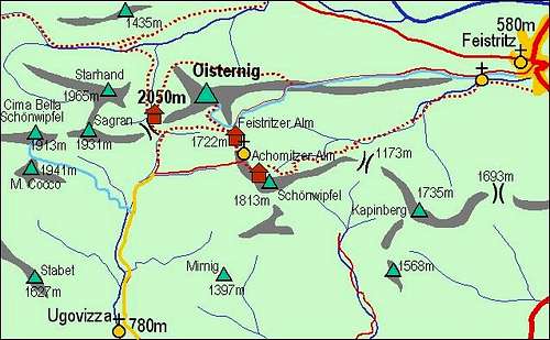
The area

Starhand summit

The ascent
0. General data: From 1130 m to 1968 m (Starhand) then down on the connecting ridge and up again on Sagran. Orientation of ski slopes: S (from Starhand), W (from Sagran), E (the last part above parking place). Gear: The usual tour skiing equipment.
1. Effort: Overall altitude difference is some 950 m. The whole circle lasts some 4 h 30 min. Adding Cima Bella/Schoenwipfel and Kuk/Monte Cocco would mean one good hour more.
2. Tour difficulty: 2 - easy. A few a bit steeper slopes, but nowhere exposed.
3. Orientation: 2 - easy, provided the visibility is good.
Overview

On the ridge

Ideal ski slopes
Half a dozen of summits in the eastern part of Carnic Alps main ridge, the ones east of Gartnerkofel, are a true tour skiing paradise. Especially in a high winter time, when higher mountains can be dangerous for ski tours, these summits offer almost andless possibilities of shorter tours, but can also be combined in quite long and enduring ski trips. So I came on the idea that the quartet of summits: Starhand, Sagran, Cima Bella and Kuk can offer a nice one day traverse, forming a great circle tour. The winter 2008/09 is unusually rich with snow, enabling also passages through the woods to be very fine. Then, during the tour my wife didn't feel good, so we shortened it, arriving on the "Camoscio" parking place only after four hours. That is why here I am describing only the Starhand-Sagran part of the traverse. More about these mountains you can read on the main page.
Getting There
The tour starts on the parking place by "Osteria del Camoscio", 1130 m, in Valle di Ugovizza. So it is the proposal for the tour from the Italian territory. The Austrian variant would also be possible, but would best be done in the reverse order of summits, and the tour would be much longer. "Osteria del Camoscio" can almost the whole winter be reached from Ugovizza/Ukve in Val Canale / Kanalska dolina. This is a small town between Tarvisio and Pontebba. See the main page how to get there. From Ugivizza/Ukve towards the north a narrow mountain road goes. It ascends over the first valley step with a few turns. That part of the road is allmost all exposed to the sun (oriented towards the south), so also in winter there are rarely problems with snow or ice. The continuation of the road into the valley is more shady. There the road is all the winter covered with snow and ice, but as the inclination is only minimal, again there are no problems even in winter. In normal conditions, except before the road is cleaned of heavy snow, it is passable till "Osteria del Camoscio" where there are many parking places. But due to the popularity of Cima Bella and other mountains, you often have a hard time finding a free parking place. The road then continues up to the next big farm, but that part is usually done with chains on tires.
Route Description
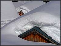
Winter scene

Dolinca huts
From "Osteria del Camoscio", 1130 m, you continue by the road till Rif. Nordio-Deffar and from there further towards the north on Lom saddle. This road is also in summer closed for public traffic, in winter it is also a quick and easy ski descent into the valley. On Lom saddle (Sella di Lom / Lomsattel), 1460 m, you are surprised by a whole village of weekend huts, standing on the Dolinca / Dolinza alpine meadow. But in winter usually there's nobody.
Just below the saddle (on the northern side), Dolinca creek makes a big turn. The upper valley continues towards the west, forming a narrow gorge between Sagran's east ridge and Starhand's south-east ridge. I don't know how conditions might be in a winter, poor with snow, but in 2009, when there were more than two meters of snow, the flat bottom of the valley was easily passable with skis. Due to the popularity of these mountains it is likely you will find also a ski track there. The summer path (the marked "Traversata Carnica" / "Karnischer Hoehenweg") goes a bit higher, by the northern slopes above the valley. That's perhaps an option for seasons, poor with snow. In the upper part, on some 1675 m, the valley branches. There, usually ski tracks come down from the summit of Sagran, by its beautiful 250 m high NE slope. There we turn right out of the ravine and in turns ascend through a steep forrest. There are no bigger problems, the forrest is light already and we all the time go comfortably on skis. Above, soon the terrain opens. We reach the bottom of the broad, grassy slope, falling down from the high ridge, connecting Starhand and Sagran. We just continue ascending towards the north, below the summit ridge of Starhand we hit the route coming up from Goertschacher Alm (where Austrians usually ascend) and continue towards the right, below the summit ridge. Just a few meters below the top we turn left and reach the highest point, 1968 m. The view from Starhand is simply great!
 Ojstrnik |
 West view |
The upper 100 meters we ski by the ascent route. If we don't want to lose altitude, then we simply keep high towards the right and so hit the high, grassy ridge, connecting Starhand and Sagran. Below the bump 1886 m, rising in the middle of the ridge, we put again skins on and continue towards the south on the summit of Sagran, 1931 m. We have less than 100 meters to ascend.
 M. Scinauz From Sagran |
 Montaž From Sagran |
From Sagran we ski down by the beautiful west ridge. It is broad and not steep, we usually find the best powder on its northern slopes. Only the last meters of the ridge are forrested and steeper, but we reach the saddle Kalten Brunner / Fontana Fredda, 1693 m, without any difficulties. Those who want to continue on Cima Bella / Schoenwipfel, should attack its eastern ridge from the NE side. I haven't ascended there yet. From Cima Bella / Schoenwipfel the most popular tour ski descent goes down to "Osteria del Camoscio". If we want to conclude the ascents on Kalten Brunner / Fontana Fredda saddle, we just continue by the mountain road towards the south, on the Italian side. The road smoothly descends and exits on the broad meadows, where hundreds of tour skiers come down from Cima Bella / Schoenwipfel. In the SE direction we ski down to the parking place. We did the ski tour in 4 hours, that is quite a realistic time. If you enjoy panoramas or take a usual rest, you might add half an hour to that. All in all an easy and enjoyable half day tour, with the prolongation on Cima Bella / Schoenwipfel and perhaps also to Kuk / Monte Cocco you should add another one hour, but the altitude difference would then rise on close to 1300 meters.