
|
|
Trip Report |
|---|---|
|
|
Dec 19, 2009 |
|
|
Hiking, Mountaineering |
|
|
Fall, Winter |
"Did we really walk this far?"
The snow crunched rhythmically under my snowshoes as I plodded down the road into darkness. It was 7 pm, and we were somewhere between Vicksburg and wherever on the 390 road we'd abandoned the Jeep.24 hours ago Jeff and I had left Denver with a plan to hike Mount Belford, Mount Oxford, and--time and energy permitting--Missouri Mountain via Elkhead Pass. A voice of reason had cautioned us against such an endeavor in winter, but I'd decided all we needed was more time; so we drove to Buena Vista, got a few hours' sleep at a motel, got up at 3 am, and reached the unploughed section of 390 around 4. After two miles of tractionless sugary snow the Jeep was defeated by an incline and we were forced to park 2.4 miles short of the Missouri Gulch trailhead.
Nearly 15 hours ago we'd started crunching rhythmically down this road in the dark towards an ambitious plan to hike three 14ers. Now we were retracing our steps with a very different set of expectations--namely, a nice prime rib and a cold beer to celebrate our one summit on this grueling but spectacular day.
 Trying to navigate 390
Setbacks and Switchbacks
It wasn't yet 5 am, and we were setting a determined pace. Being over two miles from the trailhead, we were already behind. Then ten minutes in I realized I'd left my Gatorade in the backseat. Ten minutes back to the Jeep; now it was 5.We reached the trailhead before dawn. It didn't appear anyone had been there for awhile, at least since the last snow had deposited six inches of powder on the parking lot.
As we started up the switchbacks, the snowy tops of rugged hills and ridges around us began to glow amber. Though the forecast had been for sunshine, being in a sort of trough we wouldn't feel the sun's warm rays for some time. Here it was cold, around minus five. To keep our water from freezing we cleared the tubes and tucked drinking valves into our jackets; Jeff discovered one of his had sprung a leak and was eventually forced to spill out what he couldn't drink.
After the usual summer crowds disappear, it seems wildlife assume trail maintenance duties at Missouri Gulch. We followed deer tracks on the path as it snaked up the forested hillside, laying our own superhighway in the deepening snow. Hidden underneath was a narrow avenue hardened by human and critter traffic. We tried to predict its position--any error would be accompanied by a whoosh as the ground dropped out, leaving us flailing in snow over our knees.
 Following the deer tracks
 Sunrise!
 Oops.
Oops.Narrowing Goals
The sun climbed higher in the clear blue sky, chasing the shadows down into the gulch. They seemed to follow us as we rounded a hill and emerged from timberline near the jumbled ruins of a long-abandoned log structure, the last vestige of human habitation in this alpine wilderness, occupied now only by a growing drift. Here the gulch widens into a basin confined in the east by the looming massif of Mount Belford and in the south and west by Missouri Mountain and its rugged east ridge.We soon found ourselves at the foot of Mount Belford's northwest ridge near the runout of a snow-filled couloir. Trail-builders have constructed a cairn here to guide hikers across when the snow is particularly deep. Since we could see rocks and grass poking out of the snow all along the wind-scoured ridge, we decided to dismount our snowshoes and leave them near the cairn.
It was 10:30, and we already knew we wouldn't have daylight to get Missouri Mountain. So we started up the steep ridge towards Mount Belford, whose bulk still cast us in shadow as the sun in its shallow trajectory struggled to climb above the ridge. Around 12,500' we spotted a small herd of bighorn sheep opposite the couloir, grazing on the tundra and pausing to glare across the chasm at intervals. Although evidence of wildlife had been everywhere in the soft snow, these were the only proof we'd see today.
 Looking back

 Missouri Mountain's treacherous east ridge
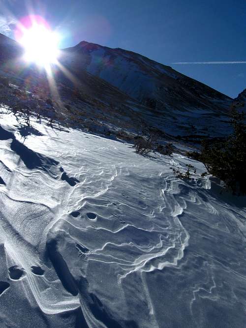 Sastrugi
 Mount Belford
 Jeff playing it cool
 Sunrise on Belford

 Standoff
Summit
Finally at 11 am the sun burst over the ridge, and we stopped for awhile to soak up the solar warmth and take in the views. I've seen photos of Missouri Gulch at its greenest, but I think that doesn't hold a candle to the serene alpine majesty of winter here. So too were we pleasantly surprised at the calm--it seemed a bitter wind would not be among our enemies today. We were instead racing the clock in hopes of reaching Mount Oxford before dusk.So we pushed onward and upward. The slope grew more abrupt and the scree more loose as we climbed above the sea of peaks. I numbly began ticking away the altitudes: 13,000.. 13,500.. 14,000..! At long last we crested the ridge near a false summit at 2 pm and after a brief, premature celebration trudged, exhausted, over to the summit block of Mount Belford, which in its jagged protrusion from the rounded hump looks oddly imposing. We scrambled up and took a rest, feasting our greedy eyes on the breathtaking panorama before us. We'd been climbing now for over nine-and-a-half hours.
It quickly dawned on us that, were we to continue on to Mount Oxford, we'd arrive on the summit at dusk and certainly wouldn't care to lose and regain the altitude yet again in returning the usual way over Belford. Then there would be the added difficulty of locating our snowshoes in the dark. So we decided to leave Mount Oxford there taunting us from across the saddle; we'd get it another time.
We knew that descending the scree we'd come up would be painfully slow, so we considered the alternatives: couloirs to the northwest, or Elkhead Pass. In retrospect I think we should have taken the couloirs, but instead I recommended we climb down to the southwest, near the pass, and skirt Belford's western slopes. Jeff went along with my suggestion, and at 2:45 we started down.
 Missouri Mountain
 Jeff sprinting up the ridge
 What am I doing?
 Looking back as we gain altitude
 Climbing above the peaks
 A whopper of a false summit
 Cresting the ridge
 Premature celebration
 Mount Belford summit block
 Jeff on the summit
 Me on the summit
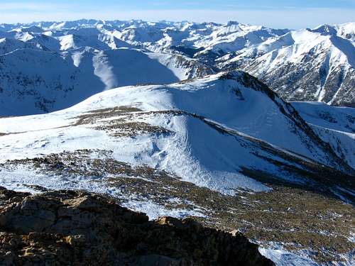 Looking back on our approach
 Proof!
 North
North West
West South
South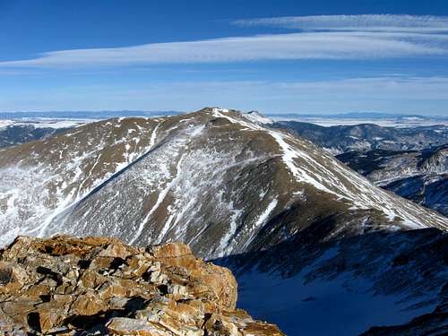 East
East Summit panorama
A Rapid Descent
On the way down we took every opportunity to attempt glissading, but the snow on the southwest aspect was patchy and mostly weak. Still, less than an hour later we were circling the base of the western slopes above the Elkhead Pass trail near 13,000'. Here we passed by some drainage which had formed great spectacular mounds of blueish ice that shimmered in the waning sunlight.Another hour found us at the snowshoes just as the sun dove behind Missouri Mountain. We strapped on our headlamps and snowshoes and plodded stuporously down the interminable switchbacks in the growing cold.
 First part of the descent
 Trying to glissade
 Jeff demonstrates self-arrest technique
 Elkhead Pass and Missouri's east ridge
 Ice near 12,500'
 Reunited with our snowshoes
 Sunset and moonrise over Missouri
Full Circle
Around 6 pm we reached the trailhead and began the seemingly endless trek down 390 towards the certain warmth and comfort of the Jeep. After an hour I wondered whether the road wasn't just an infinite snowy treadmill moving under our feet. I recalled Marco Polo's observation that "an adventure is misery and discomfort, relived in the safety of reminiscence." I couldn't wait to relive this one over a gigantic slab of prime rib. Parting shot
Details
The Mountain View Motel in Buena Vista is recently under new management and is a cheap and cozy alternative to spending the night freezing your butt off at the trailhead (our original plan).Round trip was 13 miles and 5000' of gain in just under 15 hours.


Comments
Post a Comment