
-
 7767 Hits
-
 81.84% Score
-
 14 Votes
|
|
Route |
|---|---|
|
|
42.70920°N / 103.0236°W |
|
|
Hiking |
|
|
Less than two hours |
|
|
Class 3 |
|
|
Overview
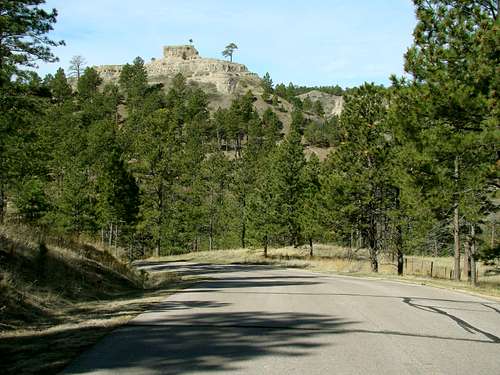 Steamboat Butte
One of the most popular short trails at Chadron State Park is the Steamboat Loop Trail. While the loop trail is only about 1.4 miles long, it provides hikers an opportunity to reach the summit block of Steamboat Butte, perhaps the state park's most famous feature. Though Chadron State Park was hit pretty hard by the 2012 forest fires that swept through Nebraska's Pine Ridge region, hard work by the state park workmen has restored most of the old luster. Hikers still have ponderosa pine forest to trek through, with generous samplings of ash and cottonwoods along the way. The loop trail begins (an ends of course) at the Sawmill Shelter, which is situated at about 4,000 feet. The trail ascends either way to the south rim of the main canyon of Chadron State Park. The high point along the trail is about 4,160 feet, at the southern end of the loop. The views down into the canyon are quite spectacular, especially early in the morning or late in the afternoon. While Steamboat Butte is the sole destination for some hikers on the Steamboat Loop Trail, others simply bypass the summit block and continue on the loop. The south end of the trail has a spur that goes to the road out to the Black Hills Overlook. There, hikers can cross the road and continue on south via the Norwesca Trail or choose to hike northwest on the road to pick up the Black Hills Overlook Trail.
Getting There
 Wildflowers along the trail
 Steamboat Butte Summit Block
To get to Chadron State Park, travel south of Chadron on Highway 385 about 8 miles, to Chadron State Park. It would probably help if you stopped at the state park headquarters and asked for a park trail map (free), plus any other questions you might have about trails, camping, or other facilities. You will need either a temporary or annual Nebraska state park permit to access the park. From the state park headquarters, take the right turn in the road loop and follow the main roadway. There is a cabin area turnoff to the left, so ignore that, as well as the camping area turnoff to the right a short distance up the road. In about 1 1/2 miles, you will come to the Sawmill Shelter (on the state park maps).
Route Information
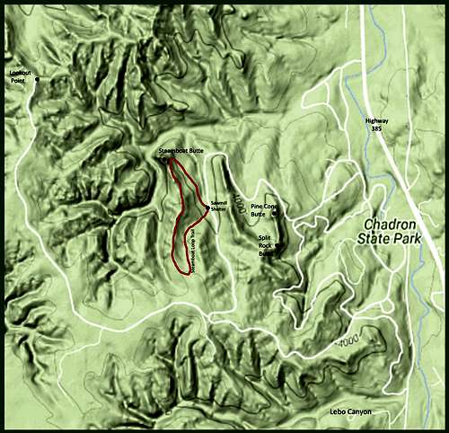 Steamboat Loop Trail Map
You can use the route map to the right, or if you prefer, you can check out the Nebraska Interactive Trail Map at this link: Nebraska Interactive Trails Map The interactive trail map will help you if you should choose to connect to other trails in the park. The trail loop distance is about 1.4 miles, with an elevation gain of about 160 feet. The trail surface is fairly smooth, even grassy in places. It is a little steep as it ascends (if hiking the loop in a counter-clockwise direction) to the Steamboat Butte summit block area. The trail can also be slippery when muddy or icy in the winter. A note of caution here on any rock climbing along the route. While the rocky surfaces might look stable, please know that "butte rock", as it is called around here, can be crumbly at times, especially when it is wet or damp. Please be careful in any climbing or venturing onto steep overlooks that depend on solid footing. From the top of Steamboat Butte down the west face, it is approximately 220 feet almost straight down to the bottom of the canyon below.
Essential Gear
 View down into the canyon
 A deer along the trail
Unless you go during the winter, when your selection of gear would be dictated by how much snow was on the ground and how cold it was, you will need only what you would normally take on a hike that takes a 1 hour. Some suggestions would include water, appropriate shoes or boots, hat, hiking pole, sunscreen, tick repellent in the spring and early summer, compass, map, rain gear if the weather forecast is questionable, and a camera. Some hikers have had problems with unrestrained dogs and choose to carry dog repellent for their own safety. To check the latest forecast and conditions for the area, click on this link: Chadron State Park Weather Forecast and Conditions
Chadron State Park Resource Information
 Steamboat Point
For more online information, check out Chadron State Park's website at: Chadron State Park For more information or to make camping or cabin reservations, you may reach the park headquarters at: (308) 432-6167 If camping and lodging facilities at the park are full, please check out the Chadron Chamber of Commerce website for more camping and lodging options. You can access their site by clicking on this link: Chadron Chamber of Commerce Camping & Lodging