
-
 4033 Hits
-
 76.66% Score
-
 7 Votes
|
|
Route |
|---|---|
|
|
47.42666°N / 11.51238°E |
|
|
Hiking, Scrambling |
|
|
Summer, Fall |
|
|
Most of a day |
|
|
A demanding hike |
|
|
Rating The Tour (By Hiking Standards)
0. General. From 958 m to 2348 m, exposition S and W. All the time marked. In the upper part an absolutely safe step is needed and two short climbing passages of UIAA I difficulty are to be climbed. By the Swiss (SAC) Hiking Scale the rating would be T4. Gear (in dry seasons): Only good shoes and poles.
1. Effort. From Falkenhuette 500 m plus 150 m up and down the summit of Mahnkopf and around Ladizkoepfl, 2 h 30 min. From the valley (through Johannestal) 900 m more. From Eng also some 1400 m, 5 h.
2. Power. 3 - medium.
3. Psyche. 4 - hard (one exposed crossing).
4. Orientation. 2 - easy, well marked (don't miss the entry into the W face crossing!) The grading system for hiking and scrambling routes is here.
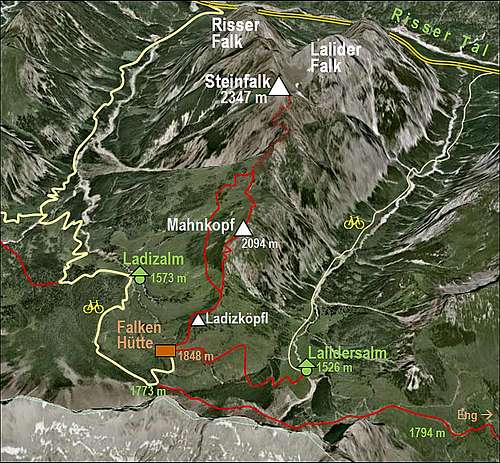
Overview & Getting There
Besides Gamsjoch and Sonnjoch, Steinfalk is one of the rare summits offering a first-class view on the Central Karwendel Chain from the north. A very valuable mountain hike of the upper difficulty, perhaps also in combination with a mountain bike ascent to Falkenhuette. See the main page of Steinfalk how to get to Falkenhuette!
Route Description

Mahnkopf from below Ladizkoepfl

On Falkenstand
From Falkenhuette you go northwards towards Ladizkoepfl. The path soon crosses a ravine and starts detouring this summit by the western side. When around, the path descends a bit on Ladizjoechl. From this nice grassy saddle it is recommended to ascend Mahnkopf and go by the detour path only on return. You wan't to see the big panorama as soon as possible, don't you! So, go directly upwards, the well marked path goes steeply in several turns, then reaches the upper meadows and ascends over them a bit to the right on Mahnkopf, 2094 m. Enjoy the view! Then descend over the meadows towards the north (don't go too far by the ridge towards the NE!) - on the broad grassy saddle below (if not before) you will find marks again. From the saddle of Falkenstand, 1965 m, you continue northwards. The well marked path first goes by the grassy ridge, which gets more steep and narrow. On the left on two places a wild view into Arzklamm (the W gorge of Steinfalk) opens. In the upper part of the grassy ridge the path enters into the W face. The path is broad enough, but very exposed (you are just above the slabs of Arzklamm) and it even descends unpleasantly at first. Here poles are useful, but if you are on a "bike and hike" tour, you probably won't have them. After crossing a smaller rocky ravine the path ascends around the edge and on the other side it crosses a steep slope upwards. You scramble carefully, the terrain is less exposed and all passages easy (no need to climb). Just before the path gains the south ridge again, there is a few meters high rocky step which you need to climb over. It's easy, rock is good, a lot of holds.
 Arzklamm |
 In the W face |
 The towers are detoured |
Now you are again on the S ridge, some rocky towers in it were detoured. The path ascends up, there's some rubble on it, exposure on the right, but no difficulties overall. The final summit rocks must be detoured again. A steep ramp goes right of them, again requiring some care. It reaches a small grassy shoulder just below the summit. There, by a memorial plate, you turn left. A few meters of easy climbing up, then carefully over the summit rocks and you are on the highest point. You return to Falkenstand saddle by the same route.
 Return on Falkenstand |
 Pastorale |
Falkenstand saddle can be reached also directly from Ladizalm (alpine meadow), so over the SW slopes, where the cattle is comming up. You can use that approach in ascent or descent, but if you are returning to Falkenhuette, you may take the marked path which detours Mahnkopf by the western side. From Falkenstand saddle it descends good 50 meters towards the SW, then it crosses mostly horizontally on Ladizjoechl and further to the hut. May be a bike is awaiting you at Falkenhuette? You will do those 900 meters of altitude and a long valley of Johannesbach in good half an hour!