
-
 30295 Hits
-
 89.76% Score
-
 30 Votes
|
|
Route |
|---|---|
|
|
46.81153°N / 121.80514°W |
|
|
Mountaineering |
|
|
Spring |
|
|
A few days |
|
|
5.4 (YDS) |
|
|
V |
|
|
Overview
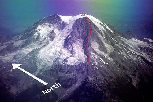
Mount Rainier
Success Cleaver Route
Success Cleaver is a 3.3-mile long rock ridge on the southwest side of Mount Rainier that rises over 8,000 feet. Success Cleaver is flanked by the South Tahoma Glacier to the north and the Pyramid and Success Glaciers to the south.
Success Cleaver has the distinction of being one of the only two climbs on Mount Rainier that does not involve significant glacier travel. Early in the season, you will be climbing on class 3 rock and steep snow. Later, when the snow melts, you will find yourself traversing across steep, exposed, unstable scree slopes. Although some claim that the danger from rockfall is minimal, there will be plenty of falling stones to keep you on your toes as you ascend the final chutes and headwall. The final rock band below the summit is low class 5.
Success Cleaver is not an exceedingly difficult climb. However, the long approach (about 10-12 miles), the long climb (8,000 feet over 3.3 miles) and the total elevation gain from the trailhead (over 11,500 feet) make for a significant endeavor that takes most parties 2 to 4 days to complete. It is possible to descend the route, but most continue over the summit and descend via another route.
|
|
|
|
|---|---|---|
|
|
|
|


Approach
General Information
There is now only one approach to Success Cleaver because the Tahoma Creek Trail is now closed due to flood hazards. The only remaining approach is from Longmire via the Wonderland Trail to Indian Henry's Hunting Ground (10 miles, 4,100-ft elevation gain).
National Park Service Information Pages
Check for location conditions:
Mt. Rainier Trails and Backcountry Camp Conditions
Mt. Rainier Wilderness Camping and Hiking Homepage
Wonderland Trail (to Indian Henry's Hunting Ground)
The approach to Success Cleaver from Longmire is very long and it is difficult right from the start. From Longmire, climb a steep switchback trail over the Rampart (about an 1,100-foot climb) and then descend about 300 feet to Kautz Creek. Cross Kautz Creek and climb up to Indian Henry's Hunting Ground and Mirror Lakes. Continue on to Success Cleaver as described above under the Tahoma Creek Trail description. This approach is 10 miles long and climbs 4,100 feet.
For the latest Longmire Trail conditions:
1. Go to Mt. Rainier Trails and Backcountry Camp Conditions
2. Scroll down to the sixth chart ("Wonderland Trail")
3. Review the trail information for "Longmire to Indian Henrys"
Bivouac Sites
If you wish to camp at the base of Success Cleaver, there is wonderful mount (point 6,631 feet) just north of Pyramid Peak that offers broad panoramas of Success Cleaver and the surround area. If you have the energy to continue, however, start ascending Success Cleaver before bivouacking. There are good bivouac locations along Success Cleaver at about 8,100-8,300 feet, 9,400 feet and 10,700 feet.

Route Description
Route finding for the first 3,000 feet is straightforward. From the start of the ridge at 6,400 feet, just follow the broad ridge all the way up to 9,400 feet.
At about 9,400 you will be forced to the east by steep rock steps. Traverse below the cliffs at the top of steep, exposed, unstable sand and scree slopes. This can be unpleasant and unnerving because the slopes are steep and there is no protection. Early in the season these slopes will be covered with snow.
|
|
|
|
|---|---|---|
|
|


Once you reach an elevation of about 10,200 feet you will bypass a couple of gendarmes. Most of them are passed to the east via really easy class 3 scrambling. At about 10,700 feet there is a nice broad saddle for a bivouac that is generally free of rockfall danger.


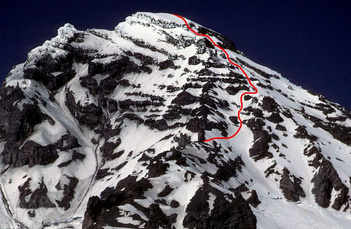
Just a little higher, at around 11,200 feet, the ridge steepens dramatically and you will be forced east off the crest again. Angle up and right across three chutes to the headwall above the Success Glacier. These chutes and the headwall are pounded by falling stones and ice, so stay on your toes. The chutes are also prone to avalanches in certain conditions. In a whiteout, route finding would be very difficult here.
Continue upwards until it is possible to ascend right up steep chutes onto the Kautz Cleaver at about 12,600 feet. Once on the Kautz Cleaver, continue up to Point Success. There are several short but steep class 3 or class 4 rock bands that you will need to climb. As you climb the steep slopes to the final rock band below Point Success, you will start to appreciate the great height and exposure. It's really wonderful.
The final short rock band below Point Success is rather difficult (low class 5). We bypassed this final class 5 rock band by traversing left across the upper Tahoma headwall (steep snow/ice in spots, very exposed, lots of debris falling from the ice-encrusted south-facing cliffs above).
Here is a photo from Cascade Climbers, taken from about 11,000 feet looking up the Tahoma headwall (left) and the crest of Success Cleaver (just right of center). The foreshortening is very exaggerated. The climbing route actually traverses right into the snow chute on the far right-hand side of the photo to gain the right skyline to the summit. At the very top of the photo is the ice-encrusted summit rock band of the Tahoma headwall (which we traversed under to gain the summit).
http://cascadeclimbers.com/plab/showfull.php?photo=15291
Compare the above photo with this one: https://www.summitpost.org/images/original/467550.jpg
Here is another report about the summit rock band from http://mountrainierconditions.blogspot.com/2013/06/success-clevear-2013.html
"...we got under the summit rock band. It was hard to find a weak spot in the final rock band and initially we even tried to go west onto the Tahoma headwall. Returning back to the east side of Success Cleaver, we climbed straight up and got to the upper snowfield via a 45 foot 60-degree snow gully with about 15 feet of 5.4 rock at the end of it."
Which is better, going straight up through the class 5 rock band or traversing left across the Tahoma headwall? My impresson is that the traverse across the top of the 8,000 foot-high Tahoma headwall is marginally better than climbing steep, loose, unprotected class 5 volcanic rock band without a belay at the top of the 8,000 foot-high Success headwall.
This photo by BSPclimber is particularly useful for scouting the upper headwall of Success Cleaver. Note the final rockband below Point Success:


Descent
In order to avoid glacier travel you will need to descend Success Cleaver. This is a serious undertaking and should not be taken lightly. There is considerable exposure on this route and a fall would likely be very bad. The traverses and steep scree slopes would be exhausting and stressful. The periodical "The Mountaineer" (Volume VII, 1914) states, "A descent via Success Cleaver holds vastly greater hazards than an ascent."
If I were going to descend Success Cleaver, I would be most worried about descending the traverses from 11,000 feet to 9,400 feet. I would also not want to descend after a long summit day, I would want to bivy somewhere and hit it when I was rested. But that's just me.
Most parties use an ascent of Success Cleaver to traverse the mountain. Descent of the trade route (Disappointment Cleaver) is common. Beware, route-finding from the summit would be very difficult in a whiteout. Fortunately, Disappointment Cleaver is heavily used and well flagged, so you will likely find the trail down once you start the descent.
Essential Gear
Alpine climbing gear: boots, crampons, ice axe, helmet, bivouac equipment.
Administrative Remarks
I constructed this page on Success Cleaver because no one else has done so. I am by no means a Rainier expert. So if you're a PNW climber and would like to take over this page, or have suggestions for improvement, please contact me.