
-
 8734 Hits
-
 76.66% Score
-
 7 Votes
|
|
Route |
|---|---|
|
|
48.35370°N / 113.37°W |
|
|
Mountaineering |
|
|
Spring, Summer, Fall, Winter |
|
|
Most of a day |
|
|
Overview of the Summit Mountain, Continental Divide Route:
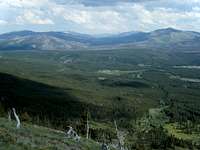
 Summit and Little Dog Mountains, cougar14 photo
Please see the Summit Mountain main page for Overview and Other Information.
Summit Mountain has only a mention in J. Gordon Edwards A Climber’s Guide To Glacier National Park on page 315. Edwards writes about an incredible ridge walk from the Two Medicine Valley to Firebrand Pass. He mentions a goat trail extending past Firebrand Pass and ending at Summit Mountain. He writes that the descent from there is easy and the trail leads out to Marias Pass.
The route featured on this page is not the Firebrand Pass route as described by Edwards.
Firebrand Pass lies along the Continental Divide to the northeast of Summit Mountain. There is a labyrinth of trails branching off of Firebrand Pass below Calf Robe Mountain that lead towards Summit Mountain. Surely one of them will lead to near Summit Mountain.
This route begins at Marias Pass on U. S. Highway 2 where it crosses the Continental Divide, enters Glacier National Park at the Autumn Creek Trailhead (Marias Pass Access Point) as it traces and crosses the Continental Divide on the human trail and then rejoins the Continental Divide at the saddle between Little Dog Mountain and Summit Mountain.
There certainly are other ways to approach Summit Mountain but the Continental Divide Route affords excellent views and two peaks for a little extra effort.
Approaching Summit Mountain, Continental Divide Route:
 Summit Mountain from Calf Robe Mountain
 Summit Mountain on the right from Marias Pass, jimegan photo.
 Summit Mountain from Firebrand Pass, distressbark photo
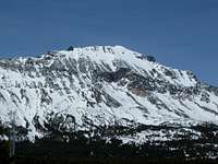 Summit Mountain in the off season, cougar14 image.
Route Statistics from Trailhead to Summit:
Total Elevation Gain: 3,557 feet
Approximate One-way Distance: 5 Miles
For a route map follow the Route Map Link.
Depart from the Autumn Creek Trailhead (Marias Pass Access Point) and travel .75 miles up the trail to the junction with the Autumn Creek Trail. (This is confusing since all of the trails are named Autumn Creek.) But once you reach this junction take the right trail and continue along for about 1 more mile.
Locating the correct location to forge through the woods is not a big deal as mid-course adjustments can be made after crossing the strip of timber between the trail and treeline.
When looking at the Marias Pass quad map there are three stream drainages flowing from near the saddle between Little Dog and Summit Mountain. The second stream bed is used to ascend and the third stream bed was used during the descent as there is a nice streambed with less vegetation and water halfway down the route from a snowfield.
The correct drainage is not difficult to identify while walking along the trail.
Leave the trail at this point and prepare to gain some elevation.
Summit Mountain, Continental Divide Route:
 Route to saddle outlined
 Summit from Little Dog
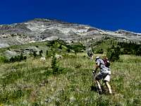
After leaving the human trail work along through the brush and trees for approximately ½ mile while gaining about 200 feet in elevation. Soon the trees will disappear and the long grassy slope will afford easier access through the lower elevations surrounding Summit.
 Above Timberline Above Timberline |
 The Grassy Ramp The Grassy Ramp |
 Transition from Slope to Scree to Solid Transition from Slope to Scree to Solid |
 View of Summit Mountain from the route View of Summit Mountain from the route |
 End of Grass Ramp End of Grass Ramp |
 Scree Slog Begins Scree Slog Begins |
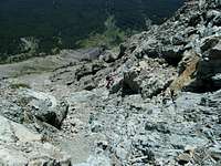
There is a yellow band of rocks that must be passed through and the best routes through this band are where the vegetation extends almost to or beyond this band.
Above the band is the worst climbing on the route as the scree is fine and therefore the footing is difficult. After a few hundred feet the scree becomes more consolidated and is interspersed with larger rocks and the beginnings of fingers of the cliffs that extend to the saddle.
Above these fingers of low lying solid rock enjoyable climbing can be found as the route travels through a selection of Class 3 and 4 rock depending upon the route chosen.
 Transition Area Transition Area |
 Finally Solid Rock Finally Solid Rock |
 Upper Cliffs Upper Cliffs |
Above the solid rock lies the saddle where at last views to the west and north over the Ole Creek drainage reveal Glacier’s fabulous Nyack region as well as presents an interesting perspective on the Two Medicine area as well.
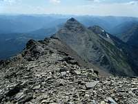
From the saddle the route climb to the climber’s right along the Continental Divide to Summit Mountain. The route to Summit Mountain is more difficult to climb than Little Dog due to extended scree slopes along the Ole Creek side of the ridge.
Initially there is a goat trail leading towards the summit. It became spotty and then non-existent as we gained elevation. The route follows the ridgeline for a short while but generally is on the left side of the ridge. There are many places along the ridge to walk in the solid rock that in interspersed with loose scree. There is a pillar on the ridge that seems to mark the transition point to the Ole Creek side of the ridge. From there the footing became more difficult as the amount of scree increased dramatically below the great cliffs above the route.
Continue underneath these cliffs until reaching a scree filled gully that will lead to the summit ridge. It is obvious when it is possible to once again climb to the ridge as there is a break in the cliffs.
After attaining the summit ridge follow the goat trail to the enjoyable 20 foot high Class 2/3 cliff that lies just below the summit.
 View from the Saddle View from the Saddle |
 Lower Cliffs Lower Cliffs |
 Dark rocks below cliffs Dark rocks below cliffs |
 Looking back on the scree slope Looking back on the scree slope |
 Summit ridge Summit ridge |
Return Options:
Retrace the route from the summit back to the saddle.There is a goat trail along the summit ridge heading toward the Little Dog/Summit saddle. We were hopeful to find an easier route down. Assuming that goats know where they are going we followed it along the top of the ridge. The trail is mostly on the Marias Pass side of the ridge. We traveled along it for a few hundred yards but eventually the trail ended at some Class 4 cliffs that we were not comfortable down-climbing. More than likely we missed a left turn to an alternate goat trail that would have taken us below the cliffs. We ended up crossing back to the ascension route and returned to the saddle.
 Marias Pass from Summit Mountain Marias Pass from Summit Mountain |
 Headed Down Headed Down |
 View to the east View to the east |
 View up from Halfway down View up from Halfway down |
 Don't Go There! Don't Go There! |
 In the Creek Drainage In the Creek Drainage |
At the saddle retrace your route through the main cliffs. There is a nice goat trail descending through the cliffs. It is not difficult to find as it begins near a stunted pine tree located in the saddle. Unfortunately goats have no need to return to the trailhead and you must leave this trail to continue the descent.
Carefully work down the slope and stay to the left (north) of your ascent route to locate the third drainage which is easier to descend due to less vegetation on the slopes. As the valley opens up it is easy to spot the proper drainage.
Eventually this drainage will reach the yellow band. There is a nice waterfall and stream which affords cool water if desired. Follow the creek as it plunges through the scree filled canyon and eventually gives way to a rocky stream bed which aids in a quick descent back to the human trail. The stream bed has a few twists and turns but the Autumn Creek Trail does cross the stream.
After reaching the trail turn to the right and head back to the junction and at that location take the left fork which will lead once again past Three Bears Lake and then to the trailhead.
Essential Gear:
 Is this your shoe?
Trekking poles will aide in your ascent and descent while working through Little Dog’s scree.
Consider bringing scree gaiters and extra water as well. There is adequate water along the trail portions of the routes. Bring a water filter if you are afraid of “Beaver Fever” (a.k.a. Giardia).
Carry bear deterrent spray. If you do not have any bear spray before getting to Glacier National Park purchase Counter Assault or UDAP at a local sporting goods store. Both of these bear sprays are Montana Made products and are effective in deterring bears when used correctly.
As with all hiking and climbing in Glacier National Park use caution and practice good manners with the wildlife. You are in Grizzly country. Carry your bear deterrent spray, don’t hike alone and make some noise. For more information please go to the Park's web site for Bear Information. The U.S. Forest Service also has helpful information on Grizzly Bear Management.
For free downloadable quad maps of Glacier National Park please see 7.5 Minute Topo Maps for Glacier National Park.
Guidebooks and Climb Registration:
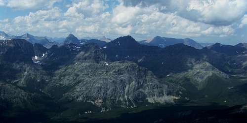 View over Ole Creek from the summit.
GUIDEBOOK: A Climber’s Guide to Glacier National Park; J. Gordon Edwards
You do not have to register for day climbs in Glacier National Park but it is recommended. Registration for climbing Summit Mountain can be accomplished at the Walton Ranger Station.
Back country travel regulations can be found at Backcountry Travel. There is also information from the Park Service on Mountain Climbing in Glacier.