Stats
Snoqualmie Mountain
Elevation: 6278 feet
Distance: 6 miles
Elevation Gain: 3100
YDS Class: 1-2 (borderline) (similiar to Mailbox Peak in difficultly but less elevation gain)Trip Report
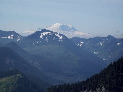
Snoqualmie Mountain is well known for having one of the best views of any of the peaks in the I-90 corridor. And on Saturday July 19, 2008 this peak more than lived up to its reputation. You would have never thought it would of though by the look of the morning fog. But this day was a special day and Snoqualmie Mountain definitely left an impression on me.
I went to this peak with partners from another site NWhikers; Jason, Fran, Todd, and Tony. We met at a park and ride and and carpooled to the trailhead. Another person joined us but he decided to go to Snow Lake instead. The drive up didn't give us much hope for views on the summit. In fact it is pretty cloudy. But the Cascades do strange things and literally as we pulled up to Snoqualmie Mountain the cloud lifted on that peak and the sun began to shine.
We took the obviously route up. Supposedly this is just a dirt path but to me it looked like a pretty established path. That being said the route up was rocky and steep with almost the entire trail being 1000+ elevation gain. About 1000 feet of elevation gain into the climb we ran into a section where the trail splits of and another a sdie trail leads to the summit of Guye Peak. There is actually a sign here showing you which way to go. Obviously even in the thick vegetation of Snoqualmie Mountain it is very hard to get lost here unless you purposes left the route.
A couple hundred yard up you come to an amazing waterfall. In winter this is the crux of the climb. But this was summer and this clearly was not the crux of the climb. In fact it made for a great resting area. The waterfall here was flowing pretty well because of the fact that the snow in the gullies above have not melted out yet. I suspect they won't melt until late August.
We proceeded on up the steep and rocky path. Once above the treeline views really began to open up of Rainier and of the other mountains in the Snoqualmie Region. Every ten feet of elevation gain increased these terrific views even more. The trail condition itself was still fairly steep but rock became almost a sand like dirt. Going up outside of kicking dust this was no problem. Coming down this became a problem and slowed us up a bit. Soon we stand at the base of the summit block.
Once we started to climb to the summit I noticed looking down that there were two paths going down. This section commes up right when you starting your final ascent of Snoqualmie Mountain summit. Note it and note that you came from the left so that you don't end up taking the wrong path down. If you took the path we did looking down this path will be on your left.
![Snoqualmie]()
![Snoqualmie]()
The path then splits into two within 30 feet of the false summit. You can continue to the false summit where you take a path that leads right next to the cliff, or you can take the very well established path roughly 200 yards to the true summit. My group checked out the false summit for a little bit then went over to the true summit 200 yards to the north. There is a third summit that looks like arete that I balieve comes within six feet of the true summits height. I don't know from experience but I would guess that getting over to this summit is at least YDS Class 4. Since we had no beta or gear we did not head over to that arete. We instead shot some great picture and goofed of on the summit over an hour and a half.
![Snoqualmie]()
Coming down started off a little interesting. Two of us got a little vertigo on the cliff side trail and were going down the first little bit on our butt. Then another person started having some knee problems. These reason are why you hike in a group. We encouraged him to stop and help him get his confidence back. Though the way dwon we were slow. We stopped off at the beautiful waterfall and then headed on back down the mountain. On this path though it is a good idea to take it slow due to all of the elevation gain and steepness. We made back down with no other major problems.
I would recommend this trip to anyone who is looking for a warmup for larger mountains in the Cascades. The views are enticing and are well woth the effort. But I wouldn't make the highlight peak of a trip, especially in the Cascades where around every corner another amazing peak with great challanges and great views can be had. Still higly worthwhile.
I want to thank my group as well. Hopefully we will go on many more adventures.


Comments
Post a Comment