
-
 4620 Hits
-
 74.01% Score
-
 4 Votes
|
|
Route |
|---|---|
|
|
46.35087°N / 13.61352°E |
|
|
Hiking |
|
|
Spring, Summer, Fall |
|
|
Half a day |
|
|
Medium hard walk up |
|
|
Rating the Route (By Hiking Standards)
 On the summit ridge
 Čelo fortifications
0. General: From 460 m to 1637 m, exposition SW. At first an easy hike up through the woods, the last 200 meters a steep, partially exposed ascent over a grassy and rocky terrain. Gear: Good hiking shoes and poles. Take enough water. You might think that the ascent is very hot in summer, but actually the forrest protects you just until the last 200 meters below the top. By the Swiss (SAC) Hiking Scale the rating would be T3.
1. Effort: cca 1180 m, 2 h 45 min.
2. Power: 2 - Easy, some pulling up on steep sections.
3. Psyche: 3 - Medium. Some exposed passages when ascending steep grassy and rocky slopes.
4. Orientation: 1 - No problems, good marked.
Overview
Svinjak is a very panoramic summit east of the big Bovec basin. It is actually the last summit in the long SW ridge of Bavški Gamsovec. From Bovec it looks as a nice, sharp pyramid, a true landmark, but the ascent by the SW ridge is not hard. The gain is a wonderful panorama on the mountains bove Soča and Koritnica rivers.Getting There
The route starts on the main road in the village Kal - Koritnica. You reach there in a few minutes from Bovec. You drive NE from the town, on the crossroads turn right (towards Soča, Vršič pass), at the entry to the village there is a big parking place. There's also inscription: "Svinjak, 2 h 30 min".The Deceiving SW Ridge - Route Description
 Kluže
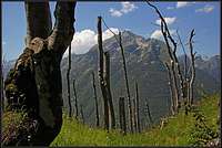
KlužeThen the path continues by the main ridge. It ascends over a few steeper parts, then again going comfortably by the ridge. On some 1200 meters the path reaches a big area of devastated woods. A strong wind cut all the tops of trees, so only logs rising towards the sky remained. Above, the path again continues by the ridge or slightly right of it. On a few places views over the NW abysses open down in Koritnica and on the mountains above it. So we reach the shoulder in the main ridge, from where the summit is already seen.
 |  |  |
At first the path still continues through more and more light woods, then grassy slopes prevail, finally turning into rocks. The slopes are steep and the narrow path requires some care. On one or two places we use hands to overcome easy rocky, then the ridge bump is reached and from it the summit is seen only a few minutes away. The summit is marked by a small replica of "Aljažev stolp" - the tower as it is on Triglav.
 Summit ridge Summit ridge |  Soča valley Soča valley |  Bovec plane Bovec plane |  The summit The summit |
We return by the same route. After descending to the point where the path first gains the main ridge, we may continue by a tiny path by the ridge. It brings us in some 15 minutes directly to the Čelo fortress, or better - military posts from the World War I, dominating the plane of Bovec, Koritnica and Soča valley.
 On Svinjak