
|
|
Route |
|---|---|
|
|
44.35400°N / 112.8217°W |
|
|
scramble |
|
|
Most of a day |
|
|
Class 2 |
|
|
 Southwest ridge
Approach
From Idaho Falls, these directions were provided by 'Biglost' in his Scott Canyon Approach directions:
From Idaho Falls, Idaho Drive north on I-15 to "Sage Junction" at exit #143, drive West through the hamlets of Terreton and Mud Lake. Just west of Mud Lake the you will encounter a junction, stay on 28 (to the right) and head towards Salmon, Idaho. From the junction drive 42.6 miles to the Nicholia Road, turn right onto this road and drive towards the Nicholia Mine for +- 3 miles, turn right and follow the road southeast for 4.5 miles and turn left up Scott Canyon to where the road is blocked at a gate. Lots of room to park here.
From Boise, the direction we came from, take I-84 to Bliss Idaho and take US 26 through Shoshone where it becomes US 26 / US 93 and heads to Carey.
From Carey, head for Arco and take US 20 / US 26 a few miles south to where
SR 22 / SR 33 heads for Howe. At Howe, go east on SR 33 a few miles and
take SR 22 to a junction with SR 28. Head north, passing through a wide spot in the road called Lone Pine and soon you'll come to the county line sign for Lemhi County. In 5.5 mile from the county line, watch for the turnoff for the Nicholia Ranch. Follow Biglost's directions as listed above to find your way to the gate he mentions in Scott Canyon.

Route Description
At the gate, you'll see just beyond it, a BLM marker indicating that the trail beyond is 006. This heads northeasterly from the gate in Scott Canyon, on an old ATV track for .9 mile where it meets a fork. Take the right part as the left drops into another canyon. The track continues to increase in elevation and soon passes a spring where a cattle trough is located. From here the track climbs steeply up a hill and heads for point 8975 as shown on this topozone map.We had another route that we were planning to follow until we saw the lower slopes of the mountain itself. It was here that Bob Bolton felt that there was another way to go and it turned out to be a great choice. I give full credit to Bob for choosing this ridge. In his words:
"I decided to try the ridge between the western cirque and Webber's SW ridge. I guess this could be called Scott's SW ridge. The only trick seemed to be getting around the big castle-like gendarme half way up, but that turned out to be no problem. I highly recommend this route as there are no difficult cliff bands, and the loose junk isn't seemingly as steep as on the other routes. The summit ridge is reached about midway between Scott and Webber." As Bob scoped out the best route, I had to agree that this made much more sense than going up the cirques or the ridge that came down from Webber Peak. Both of these other routes had cliff bands to bypass. So, back to finding the route, continue reading.
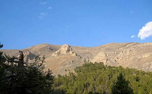
From here,look east towards the ridge that has a couple large gendarmes that are obvious landmarks and head for this ridge, first dropping a bit into a forest and then climbing up through the forest which puts you onto this ridge you were looking at. Make your way up the ridge, staying to the left (west) as you steadily gain elevation, bypassing first the smaller of the gendarmes, still on the left, and then, the bigger one. Stay close to the rock as the best footing is found here since the talus / scree everywhere else is loose and requires a lot of energy to ascend. After getting past the last gendarme (on the left), the slope opens up and pick your way up to the ridgeline at an elevation of a bit over 11,200 which leads you to both Scott and Webber Peaks.

The route (in red) as it goes up to the ridge and then hooks left to access Scott Peak. (photo by Bob Bolton)
The elevation at the trailhead is 7750 feet and the elevation of Scott Peak is 11,300+ However, with the loss of some elevation on the way in of a couple hundred feet and the necessity to regain that elevation on the way out, you can figure on about 4000 feet of elevation round trip. Should you add in the side trip to Webber Peak's two high points, you can add some more elevation gain and loss to the equation. Round trip in miles is 10 miles and 12 miles if you go to Webber. I don't remember the time it took but then everyone has a different speed anyway.
Essential Gear
Scree gaiters are a nice addition. Take plenty of water as a hot day will work up a major thirst on this peak. An early start will be the best way to do this one.