On my to do list
I approached
Jim (
Wasatchnut007) with the idea of doing both
Swasey and
Notch peaks on the same trip. We had read reports and noted that the mileage noted was around 2 miles each way and less than 2000 feet for Swasey for we figured
we could hit that one in the morning and still have enough time to go and get Notch, which distance wise isn't all that far from Swasey in the House Range, one of those great western Utah desert areas.
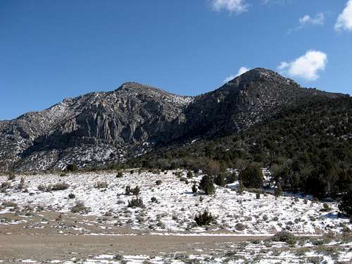
![Swasey Peak]() from the spot where we parked
from the spot where we parked
Jim and I scheduled our trip for May 1st and we'd both ride down in my truck to do battle with those two peaks. I had assembled a lot of information on both peaks and yet, in case we took longer than expected, I had
Drum Mountain, another Utah Peak as a backup for Notch. One of the reasons I really wanted Swasey Peak was that it had over 4500 feet of prominence and that alone made it come in at #11 on
Utah top 100 prominence list. One of my goals since moving to Utah was to get as many of the Utah prominence peaks as I could so it was natural for me to have it high on my to do list.
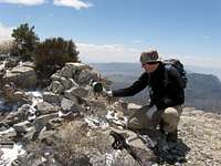
![Heading up]() Jim heads up to do battle with the brush
Jim heads up to do battle with the brushSNOW on May first?
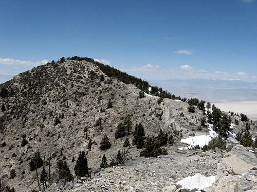
![Swasey Peak]() Swasey Peak as seen from the south ridge
Swasey Peak as seen from the south ridge
Jim and I planned to leave from my home at around 6 a.m., perhaps a bit late for two peaks considering the drive just to get there but Jim is experiencing that wonderful aspect of fatherhood where he is up often all hours of the night with a small infant who would rather sleep during the day and not during the night. Amazingly enough, after a long night, Jim showed up but both of us were taken back a bit by the snow cover that had blanketed the area. My truck was totally covered so much scraping and heating was required to get us on the road. The temperature was a balmy 21 degrees. Hmmmm.
![Route we went]() Our route up
Our route up
The drive down to Delta seemed to go quickly as Jim and I covered lots of
interesting topics that we both had interest in including the singing stars of the 50's and 60's, Buddy Holly and Creedance. Surprisingly, Jim knew the songs of those guys as well as I did. I knew I liked this guy. Throw in the Eagles and you have a perfect trio of singing sensations. As we proceeded west from Delta, all aspects of civilization dropped away. There wasn't much out here in the western Utah desert. Somewhere around the 30 mile mark from Delta (or more), we saw the dirt road turnoff ("we're out in the desert on a horse with no name..")that headed toward the mountain. The "
U-Dig Fossil" sign was a dead give away since that enterprise was located near the base of the mountain. (see link, it even has a map)
![Traversing from the false summit]() Traversing between the two saddles
Traversing between the two saddles
We could see that there was snow on the mountain and as we drove up the road we began to encounter fresh snow everywhere but nothing that would interfere with getting to the place we wanted to park at the 8000 foot level.
Into the fray
![Swasey Peak]() Bristlecone forest on north side of Swasey
Bristlecone forest on north side of Swasey
The temperature at 8000 feet was in the teens and the wind was blowing briskly so that just putting on boots had my fingers going numb in no time at all. I wisely put on all my layers before we headed across the road and up the brush covered slope. I knew I'd be taking layers off after we got moving but initially, it was just too cold not to put the extra warmth on. At first the brush wasn't too bad but as we got higher the brush would close off easy access and we'd either have to backtrack and look for an easier passage or just bulldoze our way through it. Often times we were down on hands and knees as we would crawl to an open area but although it slowed us down, I didn't find the brush as bad as some of the stuff we have to contend with in the Pacific Northwest (devils club and slide alder). Fortunately there wasn't any cactus in the stuff we crawled through and I was thankful for that. We gained elevation slowly but steadily and before long the angle of the terrain began to steepen and allowed us to move out of the brush and scrub trees onto sections of talus or broken rock. I had waypointed a route via my GPS and the route worked pretty well. We ended up making a decision as to whether we should go left up a rocky passage or to the right as my GPS indicated and we stayed with the GPS direction.
![Summit cairn and mailbox]() Summit cairn and mailbox
Summit cairn and mailbox![Swasey Peak Benchmark (UT)]() Benchmark
Benchmark
Soon Jim was on the border of the ridgeline that would lead us up to the ridge and from there we made our way up to the ridge itself where we got a nice look over to Swasey. We had to work our way around a bowl with a false summit, a saddle, another prominence and another saddle before we could get on Swasey itself. We noted the bristlecone forest that clings to the northside and were looking forward to being able to see it up close and personal. Making our way up the easy terrain was actually pleasurable and it wasn't all that long before we could see that the mountain was topping out. A small cairn marked the highest spot and not far from the cairn was a mailbox. The mailbox was in excellent condition and opening it revealed a small glass jar that contained a register and some other odds and ends.
The register was one that dated back to 1992 and it seemed that each year a few parties made it up to the summit and signed in, including the folks who put the mailbox up. I noted many familiar names and realized how small the world of desert peakbagging is. Always fun to see those names and know that they were up here as well. The last entry was in October 2007 so it had been a good seven months since the last visitors to this isolated summit had been here.
![Summit register]() Any mail in there?
Any mail in there?![1992 register]() 1992 Register
1992 Register The summit visit
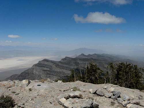
![Looking northward]() Great views
Great views
Jim and I tried to make a cell connection but our digital cells were worthless so we weren't able to call our spouses to let them know of our progress. We spent time reading the entries in the register and taking photos of the views that were very nice to the north, west and south. We noted the Benchmark as well and the rock message someone had left on the summit area. The views to the east were blocked by the bristlecone forest that came almost right up to the summit but no matter, we had those views to the east when we returned to the false summit on the way back to our vehicle. After a bite to eat and chatting about what we were seeing, it was all too soon to leave Swasey's summit. We knew thanks to the time that it had taken us to get up that there wouldn't be a second peak today. That was o.k. as we really wanted to savor the experience we had enjoyed on Swasey. The wind had died down and we weren't cold at all on the summit and from the time we hit the summit to the time we returned to our vehicle, there was no need to put any of the extra layers back on. The day had just kept getting better and better. We took a good look down the Sinbad canyon route and even though it was very direct, it wasn't for us and we would return the way we came. I could actually see my truck parked down there and it was sure enticing.
Back into the fray
![Heading back]() On the south ridge
On the south ridge
We made our adios to the summit and headed back down. One little snow slope on the way back up to the false summit ridge was interesting as it seemed to contain the majority of the snow we had to go through on that side of the ridge. We found that all the snow we had come up through earlier in the day had melted away and once we hit the brush, Jim became a Mack Truck and just blasted his way through everything. I just followed. We made it back to the truck in 90 minutes and despite taking a different route down from the one we had taken up, it went well. I did sacrifice a glove to the mountain as the brush must have snagged it from where I had it stowed.
At the truck it was time for a high five and the journey home. Would I return to Swasey someday? Probably not but I certainly will always have a fond spot for this lonely mountain in my memory. Much thanks to Jim for being the perfect partner. It was a great day.
Totals: 4 miles overall with a smidgen under 2000 feet of elevation gain.
Also a special thanks to
MountainGazelle for her pics of her route that she shared with me from her visit via the southwest ridge. They were appreciated and the information contained on the SP page by
Scott Patterson was a great help. Notch Peak is now moved up another notch on my to do list.
I like to refer to all the ranges in the western Utah desert as "the Outback" as you are a long way from just about everything after you leave Delta. The area has quite a history and Mike Kelsey has written an interesting book on some of the area called
"Jack Watson and....."


Comments
Post a Comment